TopoQuest Logo
Do you find TopoQuest useful?
Help keep TopoQuest running and adding new maps/features by donating!
Bitcoin:  19c7KJd3qBynnjoSw5npx9KScwjBe4ifkT
Litecoin:  LXs6TkuXGGXo1vDsWCkWVdjQX94eUKd6ui
Home View Maps Find Maps Find Places Resources & Links


Leonard, Oklahoma Topographic Map

USGS Map Title: Leonard, OK
USGS Map MRC: 35095H7
DRG (GeoTIFF) Download: o35095h7.tif


Neighboring USGS Topographic Map Quads:


  Jenks, OK  
36095A8
 

  Broken Arrow, OK  
36095A7
 

  Oneta, OK  
36095A6
 

  Bixby, OK  
35095H8
 

  Leonard, OK  
35095H7
 

  Coweta, OK  
35095H6
 

  Spanish Peak, OK  
35095G8
 

  Concharty Mountain, OK  
35095G7
 

  Haskell, OK  
35095G6


Map MRC Location:

N36°
W96°
N36°
W95°
H8 H7 H6 H5 H4 H3 H2 H1
G8 G7 G6 G5 G4 G3 G2 G1
F8 F7 F6 F5 F4 F3 F2 F1
E8 E7 E6 E5 E4 E3 E2 E1
D8 D7 D6 D5 D4 D3 D2 D1
C8 C7 C6 C5 C4 C3 C2 C1
B8 B7 B6 B5 B4 B3 B2 B1
A8 A7 A6 A5 A4 A3 A2 A1
N35°
W96°
N35°
W95°

Leonard, OK USGS 1:24K Topographic Map Preview:
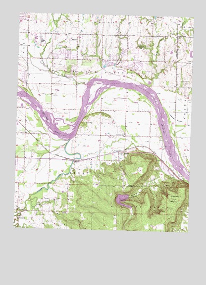
Leonard, OK USGS Topographic Map
Click on map above to begin viewing in our Map Viewer.

This topographic map contains these locations and features:
Feature Name Type Latitude Longitude GNIS ID View Map
Apueka CemeteryCemeteryN35.9822°W95.7614°2724115View Map
Aspen Park Baptist ChurchChurchN35.9737°W95.8155°1782578View Map
Bible Baptist ChurchChurchN35.9143°W95.8689°1782517View Map
Bixhoma DamDamN35.8951°W95.7953°1750996View Map
Bixhoma LakeReservoirN35.8931°W95.7979°1750997View Map
Broken Arrow Fire Department Station 3BuildingN35.9763°W95.7977°2657512View Map
Broken Arrow WaterworksLocaleN35.9809°W95.7867°1101991View Map
Childers Middle SchoolSchoolN35.9875°W95.7854°1803851View Map
Conjada MountainsSummitN35.8948°W95.7605°1091612View Map
Grace Free Will Baptist ChurchChurchN35.9690°W95.8153°1782606View Map
Hailkey CreekStreamN35.9595°W95.8283°1763763View Map
Indian Springs Baptist ChurchChurchN35.9762°W95.7975°1782608View Map
Indian Springs Elementary SchoolSchoolN35.9658°W95.8091°1803861View Map
Indian Springs PlazaLocaleN35.9765°W95.7967°1778220View Map
KAKC-AM (Tulsa)TowerN35.9945°W95.8578°1102778View Map
LeonardPopulated PlaceN35.9204°W95.7994°1094583View Map
Leonard Christian Fellowship ChurchChurchN35.9157°W95.8058°1798510View Map
Leonard Elementary SchoolSchoolN35.9308°W95.7976°1094584View Map
Sanger CemeteryCemeteryN35.8955°W95.8742°2705506View Map
Shepherd of the Hills ChurchChurchN35.9798°W95.8514°1782616View Map
Simmons CemeteryCemeteryN35.9626°W95.7530°1098054View Map
Snake CreekStreamN35.8759°W95.8750°1098146View Map
Snake Creek CemeteryCemeteryN35.8842°W95.8547°2705507View Map
Spring Creek Elementary SchoolSchoolN35.9862°W95.7873°1803864View Map
Township of BixbyCivilN35.9012°W95.8433°1824520View Map
Township of Willow SpringsCivilN35.9654°W95.8153°1824519View Map
Trinity Lutheran ChurchChurchN35.9962°W95.7978°1782621View Map
Vernon SchoolSchoolN35.8809°W95.8717°1099247View Map
White ChurchChurchN35.9845°W95.8342°1099695View Map
White Church CemeteryCemeteryN35.9858°W95.8333°2705510View Map

Note: Coordinates in the location and feature list above are referenced to NAD83 datum.


Copyright (C) 2008-2024 Ryan Niemi / Sunset Dynamics ... All Rights Reserved