TopoQuest Logo
Do you find TopoQuest useful?
Help keep TopoQuest running and adding new maps/features by donating!
Bitcoin:  19c7KJd3qBynnjoSw5npx9KScwjBe4ifkT
Litecoin:  LXs6TkuXGGXo1vDsWCkWVdjQX94eUKd6ui
Home View Maps Find Maps Find Places Resources & Links


Avondale, Tennessee Topographic Map

USGS Map Title: Avondale, TN
USGS Map MRC: 36083C4
DRG (GeoTIFF) Download: o36083c4.tif


Neighboring USGS Topographic Map Quads:


  Tazewell, TN  
36083D5
 

  Howard Quarter, TN  
36083D4
 

  Swan Island, TN  
36083D3
 

  Dutch Valley, TN  
36083C5
 

  Avondale, TN  
36083C4
 

  Bean Station, TN  
36083C3
 

  Joppa, TN  
36083B5
 

  Talbott, TN  
36083B4
 

  Morristown, TN  
36083B3


Map MRC Location:

N37°
W84°
N37°
W83°
H8 H7 H6 H5 H4 H3 H2 H1
G8 G7 G6 G5 G4 G3 G2 G1
F8 F7 F6 F5 F4 F3 F2 F1
E8 E7 E6 E5 E4 E3 E2 E1
D8 D7 D6 D5 D4 D3 D2 D1
C8 C7 C6 C5 C4 C3 C2 C1
B8 B7 B6 B5 B4 B3 B2 B1
A8 A7 A6 A5 A4 A3 A2 A1
N36°
W84°
N36°
W83°

Avondale, TN USGS 1:24K Topographic Map Preview:
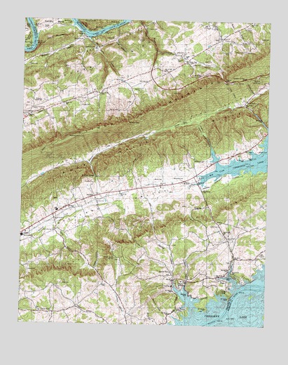
Avondale, TN USGS Topographic Map
Click on map above to begin viewing in our Map Viewer.

This topographic map contains these locations and features:
Feature Name Type Latitude Longitude GNIS ID View Map
Adkins CemeteryCemeteryN36.3454°W83.4238°1275483View Map
Adkins CemeteryCemeteryN36.3506°W83.3791°1275484View Map
AvondalePopulated PlaceN36.3026°W83.4627°1314610View Map
Avondale CemeteryCemeteryN36.3034°W83.4624°1316572View Map
Avondale ChurchChurchN36.3081°W83.4635°1304903View Map
Avondale Lookout TowerTowerN36.3268°W83.4755°1647764View Map
Avondale School (historical)SchoolN36.3079°W83.4610°1316573View Map
Avondale SpringsPopulated PlaceN36.3106°W83.4624°1276019View Map
Batman CemeteryCemeteryN36.3470°W83.4402°1316575View Map
Beech GrovePopulated PlaceN36.3670°W83.4696°1314651View Map
Beech Grove ChurchChurchN36.3429°W83.4718°1305065View Map
Beech Grove School (historical)SchoolN36.3662°W83.4707°1316576View Map
Big Q EstatesPopulated PlaceN36.2668°W83.4196°1310513View Map
Big SlipBarN36.3618°W83.4971°1644566View Map
Black Sulfur SpringSpringN36.3112°W83.4630°1644567View Map
BoggsPopulated PlaceN36.2684°W83.3943°1310516View Map
BowenPopulated PlaceN36.3073°W83.4285°1310517View Map
Bowen CemeteryCemeteryN36.3095°W83.4327°1316578View Map
Bray CemeteryCemeteryN36.3565°W83.4085°1316579View Map
Broken ValleyValleyN36.3592°W83.4760°1278454View Map
Central PointLocaleN36.2548°W83.4835°1280178View Map
Central Point Baptist ChurchChurchN36.2554°W83.4896°1644572View Map
Central Point CemeteryCemeteryN36.2562°W83.4893°1317664View Map
Central Point School (historical)SchoolN36.2543°W83.4888°1316583View Map
Christian HollowValleyN36.2645°W83.4160°1280526View Map
Clinch Mountain SchoolSchoolN36.3404°W83.3874°1280739View Map
Coffey CemeteryCemeteryN36.3684°W83.3796°1280866View Map
Coffey ChapelChurchN36.3629°W83.3868°1316588View Map
Collins CemeteryCemeteryN36.3673°W83.4535°1316589View Map
Commissioner District 2CivilN36.2610°W83.4493°2463922View Map
Condry BendBendN36.3737°W83.4852°1281077View Map
Condry CemeteryCemeteryN36.3401°W83.4705°1281078View Map
Condry CemeteryCemeteryN36.3717°W83.4902°1281079View Map
Copper Ridge PointCapeN36.3629°W83.4977°1644775View Map
Dalton CemeteryCemeteryN36.3559°W83.4974°1281987View Map
DotsonPopulated PlaceN36.3356°W83.4971°1314967View Map
Dotson Campground ChurchChurchN36.3390°W83.4949°1306391View Map
Dotson CemeteryCemeteryN36.3390°W83.4968°1317666View Map
Dotson School (historical)SchoolN36.3354°W83.4988°1317667View Map
Farmer CemeteryCemeteryN36.3381°W83.4516°1284136View Map
Floyd CemeteryCemeteryN36.3329°W83.4188°1316598View Map
Free Stone SpringSpringN36.3112°W83.4621°1644576View Map
Gilmore DockLocaleN36.2698°W83.3907°1285430View Map
Gouge KnobSummitN36.3737°W83.4657°1285750View Map
Grace ChurchChurchN36.3084°W83.4168°1316604View Map
Grove CemeteryCemeteryN36.2662°W83.4557°1316603View Map
HeltonPopulated PlaceN36.2920°W83.3996°1315215View Map
Helton CemeteryCemeteryN36.2912°W83.3993°1287351View Map
Helton SchoolSchoolN36.2826°W83.3930°1287355View Map
Helton Springs CemeteryCemeteryN36.2890°W83.4830°1317669View Map
Helton Springs ChurchChurchN36.2893°W83.4824°1287356View Map
Hipsher CemeteryCemeteryN36.3715°W83.4374°1287902View Map
Holston CemeteryCemeteryN36.2776°W83.3796°1317670View Map
Holston ChurchChurchN36.2779°W83.3799°1288140View Map
Honey CreekStreamN36.2670°W83.3902°1288197View Map
Hopper BluffPopulated PlaceN36.2643°W83.3957°1310530View Map
IdolPopulated PlaceN36.3668°W83.4016°1315281View Map
Idol CemeteryCemeteryN36.3676°W83.4007°1317671View Map
Iron Water SpringSpringN36.3110°W83.4627°1644582View Map
Kettle HollowValleyN36.2728°W83.4617°1290116View Map
Kidwell CemeteryCemeteryN36.2720°W83.4960°1290142View Map
Kincaid CemeteryCemeteryN36.3592°W83.4221°1316611View Map
Lake Forest EstatesPopulated PlaceN36.2562°W83.4180°1310532View Map
Lake Shore ChurchChurchN36.2795°W83.3782°1306661View Map
Lamb CemeteryCemeteryN36.3623°W83.3955°1290543View Map
Lathin CemeteryCemeteryN36.3573°W83.4105°1290673View Map
Limestone School (historical)SchoolN36.2876°W83.4780°1316617View Map
Lithia SpringSpringN36.3118°W83.4630°1644585View Map
Little Broken ValleyValleyN36.3748°W83.4735°1310718View Map
McCarty RidgeRidgeN36.2581°W83.4296°1293132View Map
McConnell CemeteryCemeteryN36.3104°W83.4230°1316620View Map
McCullough BendBendN36.3687°W83.4993°1293227View Map
McGinnis CemeteryCemeteryN36.3637°W83.4646°1293323View Map
McGinnis Harrell CemeteryCemeteryN36.3417°W83.4896°1293324View Map
Mount Pleasant ChurchChurchN36.3679°W83.4005°1306786View Map
Narrow ValleyLocaleN36.2718°W83.4232°1295236View Map
Narrow ValleyValleyN36.2636°W83.4187°1295237View Map
Narrow Valley Baptist ChurchChurchN36.2718°W83.4235°1644594View Map
Narrow Valley CemeteryCemeteryN36.2712°W83.4232°1317682View Map
Narrow Valley School (historical)SchoolN36.2709°W83.4230°1316625View Map
New Prospect CemeteryCemeteryN36.2865°W83.3949°1317686View Map
New Prospect ChurchChurchN36.2862°W83.3946°1295621View Map
Noe CreekStreamN36.2556°W83.3938°1311689View Map
Notchy CreekStreamN36.3670°W83.4668°1295998View Map
Notchy GapGapN36.3331°W83.4463°1296000View Map
Nuckles BranchStreamN36.3445°W83.3824°1296009View Map
Nuckles SpringSpringN36.3520°W83.3876°1296010View Map
Oak Hill ChurchChurchN36.3726°W83.3880°1306849View Map
Owl HollowValleyN36.3721°W83.4527°1296602View Map
Poor Valley RidgeRidgeN36.3262°W83.4280°1303525View Map
Prospect School (historical)SchoolN36.2856°W83.3952°1316630View Map
Red Sulfur SpringSpringN36.3120°W83.4632°1644604View Map
Rhea CemeteryCemeteryN36.3587°W83.4082°1316632View Map
Richland CemeteryCemeteryN36.2981°W83.4724°1299353View Map
Richland ChurchChurchN36.3004°W83.4618°1299355View Map
Riddle CemeteryCemeteryN36.3676°W83.4691°1299384View Map
Rock HavenPopulated PlaceN36.3415°W83.3871°1299762View Map
Rock Haven ChurchChurchN36.3459°W83.3818°1299763View Map
Rocky BranchStreamN36.2906°W83.4849°1299867View Map
Rucker CemeteryCemeteryN36.3662°W83.3896°1300226View Map
Russel Spout SpringSpringN36.2772°W83.4521°1300299View Map
Shields CemeteryCemeteryN36.3209°W83.3966°1316639View Map
Shields CreekStreamN36.3154°W83.3993°1270061View Map
Skinfoot RidgeRidgeN36.2806°W83.4177°1310555View Map
Slave CemeteryCemeteryN36.3617°W83.4221°1316640View Map
Southern DockLocaleN36.2629°W83.4141°1303737View Map
Sulphur Springs HollowValleyN36.3154°W83.3995°1310557View Map
Thorn HillPopulated PlaceN36.3584°W83.4174°1314397View Map
Thorn Hill ChurchChurchN36.3501°W83.4374°1272563View Map
Thorn Hill GapGapN36.3512°W83.3980°1276549View Map
Thorn Hill Post OfficePost OfficeN36.3598°W83.4144°1650552View Map
Thorn Hill SchoolSchoolN36.3520°W83.4305°1272564View Map
Thorn Hill Volunteer Fire DepartmentBuildingN36.3671°W83.4011°2654463View Map
Turley Bridge (historical)BridgeN36.2534°W83.3966°1316642View Map
Turley Ferry (historical)CrossingN36.2534°W83.3966°1310561View Map
Turley Island (historical)IslandN36.2659°W83.3805°1310562View Map
Turley Mills (historical)Populated PlaceN36.2634°W83.4180°1310563View Map
West CemeteryCemeteryN36.2667°W83.4780°1316646View Map
White CemeteryCemeteryN36.3623°W83.3888°1274353View Map
White Sulfur SpringSpringN36.3109°W83.4620°1644614View Map
Whitehead CemeteryCemeteryN36.3176°W83.4124°1274416View Map
Williams CemeteryCemeteryN36.3220°W83.3793°1274671View Map
Wolfe DamDamN36.3109°W83.4900°1302499View Map
Wolfe LakeReservoirN36.3112°W83.4894°1302498View Map

Note: Coordinates in the location and feature list above are referenced to NAD83 datum.


Copyright (C) 2008-2024 Ryan Niemi / Sunset Dynamics ... All Rights Reserved