TopoQuest Logo
Do you find TopoQuest useful?
Help keep TopoQuest running and adding new maps/features by donating!
Bitcoin:  19c7KJd3qBynnjoSw5npx9KScwjBe4ifkT
Litecoin:  LXs6TkuXGGXo1vDsWCkWVdjQX94eUKd6ui
Home View Maps Find Maps Find Places Resources & Links


Bean Station, Tennessee Topographic Map

USGS Map Title: Bean Station, TN
USGS Map MRC: 36083C3
DRG (GeoTIFF) Download: o36083c3.tif


Neighboring USGS Topographic Map Quads:


  Howard Quarter, TN  
36083D4
 

  Swan Island, TN  
36083D3
 

  Lee Valley, TN  
36083D2
 

  Avondale, TN  
36083C4
 

  Bean Station, TN  
36083C3
 

  Russellville, TN  
36083C2
 

  Talbott, TN  
36083B4
 

  Morristown, TN  
36083B3
 

  Springvale, TN  
36083B2


Map MRC Location:

N37°
W84°
N37°
W83°
H8 H7 H6 H5 H4 H3 H2 H1
G8 G7 G6 G5 G4 G3 G2 G1
F8 F7 F6 F5 F4 F3 F2 F1
E8 E7 E6 E5 E4 E3 E2 E1
D8 D7 D6 D5 D4 D3 D2 D1
C8 C7 C6 C5 C4 C3 C2 C1
B8 B7 B6 B5 B4 B3 B2 B1
A8 A7 A6 A5 A4 A3 A2 A1
N36°
W84°
N36°
W83°

Bean Station, TN USGS 1:24K Topographic Map Preview:
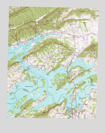
Bean Station, TN USGS Topographic Map
Click on map above to begin viewing in our Map Viewer.

This topographic map contains these locations and features:
Feature Name Type Latitude Longitude GNIS ID View Map
Adriel ChurchChurchN36.3120°W83.2891°1304772View Map
Adril Church (historical)ChurchN36.2812°W83.2943°1316571View Map
Annex CreekStreamN36.3587°W83.3366°1275764View Map
Annex SpringSpringN36.3587°W83.3463°1275765View Map
Barnards Grove ChurchChurchN36.3476°W83.2957°1304962View Map
Bean StationPopulated PlaceN36.3437°W83.2841°1276544View Map
Bean Station CemeteryCemeteryN36.3420°W83.2799°1317659View Map
Bean Station CemeteryCemeteryN36.3284°W83.3696°1276545View Map
Bean Station ChurchChurchN36.3306°W83.3677°1305008View Map
Bean Station Division (historical)CensusN36.3343°W83.3252°1648712View Map
Bean Station Elementary SchoolSchoolN36.3340°W83.3521°1648228View Map
Bean Station Police DepartmentBuildingN36.3443°W83.2839°2766026View Map
Bean Station Post OfficePost OfficeN36.3451°W83.2935°1650522View Map
Bean Station Volunteer Fire DepartmentBuildingN36.3426°W83.2834°2654329View Map
BeansPopulated PlaceN36.3314°W83.3681°1307403View Map
Beech RidgeRidgeN36.3015°W83.2716°1276854View Map
Big Hill ChurchChurchN36.3734°W83.2527°1277312View Map
Big RidgeRidgeN36.3326°W83.3196°1277366View Map
Boatman MountainRidgeN36.2554°W83.3202°1305329View Map
Boyd KnobSummitN36.3287°W83.3038°1278116View Map
Boyd Knob HollowValleyN36.3084°W83.2980°1278117View Map
Briar ForkStreamN36.3398°W83.3332°1278311View Map
Briar Fork Church (historical)ChurchN36.3495°W83.3385°1316580View Map
Briar HollowValleyN36.3593°W83.3360°1647352View Map
Buck HollowValleyN36.3333°W83.3613°1278821View Map
Buck Hollow CemeteryCemeteryN36.3345°W83.3591°1317661View Map
Caldwell CemeteryCemeteryN36.3456°W83.2641°1279312View Map
Cave SpringSpringN36.2684°W83.3093°1311605View Map
Cave Spring ValleyValleyN36.2726°W83.3118°1311606View Map
Central ChurchChurchN36.3426°W83.2796°1305822View Map
Cherokee ParkPopulated PlaceN36.2731°W83.2546°1311610View Map
Chestnut GroveWoodsN36.3184°W83.3188°1280381View Map
Chestnut Grove CemeteryCemeteryN36.3187°W83.3188°1317665View Map
Chestnut Grove SchoolChurchN36.3184°W83.3185°1316584View Map
City of Bean StationCivilN36.3490°W83.3074°2403829View Map
Cobb CemeteryCemeteryN36.3190°W83.3643°1280822View Map
Collins CemeteryCemeteryN36.3742°W83.3618°1281000View Map
Collins RidgeRidgeN36.2926°W83.2857°1281014View Map
Commissioner District 5CivilN36.3070°W83.3245°2464445View Map
Commissioner District 6CivilN36.2595°W83.3279°2464534View Map
Commissioner District 7CivilN36.2594°W83.2608°2464610View Map
Corbin EstatesPopulated PlaceN36.2543°W83.2657°1311617View Map
Cornette DockLocaleN36.2709°W83.2824°1281321View Map
Coulters ShoalsBarN36.2784°W83.3124°1644574View Map
CrosbyPopulated PlaceN36.2931°W83.2863°1647354View Map
Crosby School (historical)SchoolN36.2868°W83.2938°1316590View Map
D A Green BridgeBridgeN36.2640°W83.2843°1306251View Map
Dalton CemeteryCemeteryN36.3429°W83.3296°1281986View Map
Dalton KnobSummitN36.2559°W83.3213°1281993View Map
Davis RidgeRidgeN36.3618°W83.2718°1282204View Map
Dodson CemeteryCemeteryN36.2990°W83.2868°1282567View Map
East RidgePopulated PlaceN36.2523°W83.2513°1311629View Map
Ford CemeteryCemeteryN36.2904°W83.3071°1284564View Map
Gaby HillsPopulated PlaceN36.2504°W83.2988°1311639View Map
Gap BranchStreamN36.3234°W83.3685°1310525View Map
Garrett CemeteryCemeteryN36.3415°W83.3082°1285192View Map
German CreekStreamN36.2965°W83.3282°1285315View Map
German Creek Cabin AreaLocaleN36.2920°W83.3516°1285316View Map
German Creek DockLocaleN36.3043°W83.3477°1285317View Map
German ShoalsBarN36.2965°W83.3280°1644577View Map
Grainger County ParkParkN36.3431°W83.3307°1316602View Map
Hamblen County ParkParkN36.2620°W83.2771°1286621View Map
Hamblen DockLocaleN36.2662°W83.2732°1286622View Map
Harrell CemeteryCemeteryN36.3076°W83.3463°1286931View Map
Harrell ParkParkN36.3034°W83.3313°1286933View Map
Harris CemeteryCemeteryN36.3056°W83.3307°1286970View Map
Harris ShoalsBarN36.2659°W83.2921°1644578View Map
Heath ChapelChurchN36.2851°W83.3616°1287293View Map
Heath Chapel CemeteryCemeteryN36.2849°W83.3617°1317668View Map
Heath SpringSpringN36.2868°W83.3618°1310527View Map
Holston (historical)Populated PlaceN36.2687°W83.2846°1310529View Map
Holston ChapelChurchN36.2734°W83.2541°1288138View Map
Holston Church (historical)ChurchN36.2920°W83.3407°1316607View Map
Holt School (historical)SchoolN36.2506°W83.3685°1319980View Map
Indian HIllsPopulated PlaceN36.2781°W83.3218°1311654View Map
Isenberg CemeteryCemeteryN36.3559°W83.2579°1289073View Map
James ChapelChurchN36.3159°W83.2516°1289272View Map
Johnson RidgeRidgeN36.2890°W83.2704°1289651View Map
Kirkham School (historical)SchoolN36.3184°W83.2941°1316612View Map
LakemoorePopulated PlaceN36.2529°W83.2827°1290505View Map
Lakeview SchoolSchoolN36.3093°W83.2946°1290529View Map
Lakewood EstatesPopulated PlaceN36.2570°W83.2704°1311670View Map
Light House ChurchChurchN36.3351°W83.3568°1291267View Map
Little Poor ValleyValleyN36.3579°W83.3360°1291623View Map
Little Poor Valley RidgeRidgeN36.3565°W83.3202°1291626View Map
Livingston CemeteryCemeteryN36.2787°W83.2791°1291740View Map
Lizard Ridge School (historical)SchoolN36.3190°W83.3193°1316618View Map
Long Ferry (historical)CrossingN36.2790°W83.2657°1310537View Map
Macedonia ChurchChurchN36.2695°W83.3305°1292420View Map
Macedonia School (historical)SchoolN36.2698°W83.3299°1319989View Map
Manns CreekStreamN36.2681°W83.2774°1645039View Map
Marguerita School (historical)SchoolN36.2526°W83.2607°1319992View Map
MargueritePopulated PlaceN36.2559°W83.2579°1315466View Map
Marshalls Ferry (historical)CrossingN36.2965°W83.3263°1644588View Map
Marshalls Ford (historical)CrossingN36.2715°W83.2788°1644589View Map
Marshalls ShoalsBarN36.2890°W83.2571°1644590View Map
Marshalls ShoalsBarN36.2659°W83.2782°1644591View Map
Mary ChapelChurchN36.3015°W83.3574°1292858View Map
Mary ChapelPopulated PlaceN36.3020°W83.3577°1310540View Map
Marys Chapel CemeteryCemeteryN36.3012°W83.3568°1317678View Map
McGinnis CemeteryCemeteryN36.3159°W83.3646°1293322View Map
Meadow BranchStreamN36.3443°W83.3021°1293487View Map
Meadow BranchPopulated PlaceN36.3570°W83.2813°1647358View Map
Meadow Branch CemeteryCemeteryN36.3573°W83.2821°1317679View Map
Meadow Branch ChurchChurchN36.3568°W83.2821°1306739View Map
Meeks CemeteryCemeteryN36.3209°W83.2788°1293539View Map
Mill Spring Branch (historical)StreamN36.2829°W83.3560°1310545View Map
Miller BranchStreamN36.3584°W83.3366°1310546View Map
Miller HollowValleyN36.3579°W83.3350°1293951View Map
Moore ChapelChurchN36.3493°W83.2896°1294282View Map
Moores Chapel CemeteryCemeteryN36.3490°W83.2896°1317680View Map
Mooresburg ValleyValleyN36.3170°W83.2779°1294322View Map
Morristown Municipal Power HouseBuildingN36.2612°W83.2857°1320000View Map
Moseley RidgeRidgeN36.3306°W83.2571°1294480View Map
Mountain View ChurchChurchN36.3581°W83.3357°1294952View Map
Mountain View MeadowsPopulated PlaceN36.2645°W83.2627°1311685View Map
Mullins School (historical)SchoolN36.3618°W83.2932°1316624View Map
Murray CemeteryCemeteryN36.3070°W83.3566°1295137View Map
Murray CemeteryCemeteryN36.3168°W83.3204°1295138View Map
New Adriel CemeteryCemeteryN36.3126°W83.2896°1317683View Map
Newman HollowValleyN36.3025°W83.3241°1295694View Map
Nicholson CemeteryCemeteryN36.3145°W83.2554°1295735View Map
Noeton (historical)Populated PlaceN36.2995°W83.3332°1310547View Map
Noeton ChurchChurchN36.3168°W83.3210°1295798View Map
Overbay CemeteryCemeteryN36.3201°W83.3107°1296538View Map
Payne Island (historical)IslandN36.2826°W83.3152°1310551View Map
Ray CreekStreamN36.3159°W83.3582°1303532View Map
RidgewoodPopulated PlaceN36.2529°W83.2621°1311704View Map
RiverviewPopulated PlaceN36.2868°W83.3680°1315815View Map
Riverview Baptist ChurchChurchN36.2845°W83.3646°1644605View Map
Rock of Ages School (historical)SchoolN36.2679°W83.3507°1320019View Map
Rocky SpringSpringN36.3418°W83.2921°1299931View Map
Rocky Summit (historical)Populated PlaceN36.2890°W83.3063°1310553View Map
Rocky Summit CemeteryCemeteryN36.2984°W83.2804°1317690View Map
Rocky Summit ChurchChurchN36.2987°W83.2799°1306966View Map
Samsel CemeteryCemeteryN36.3115°W83.2924°1300648View Map
Sheltons Ford (historical)CrossingN36.2843°W83.3332°1644607View Map
Sheltons ShoalsBarN36.2834°W83.3341°1644608View Map
Spout SpringSpringN36.2545°W83.2918°1271035View Map
Spring CreekStreamN36.2698°W83.2741°1271085View Map
Stony Point KnobSummitN36.3706°W83.2768°1271526View Map
Stubblefield CreekStreamN36.2506°W83.2688°1271615View Map
Sugar HollowValleyN36.3185°W83.3219°1647362View Map
Sycamore Island (historical)IslandN36.2779°W83.3146°1310558View Map
Tate SpringsPopulated PlaceN36.3401°W83.3457°1304010View Map
TimbercrestPopulated PlaceN36.2709°W83.3271°1311717View Map
Turkey CreekStreamN36.2612°W83.2882°1304193View Map
Valley View ChurchChurchN36.3170°W83.2596°1304290View Map
Wildcat BranchStreamN36.3090°W83.3268°1310565View Map
Wildcat HollowValleyN36.3035°W83.3286°1274546View Map
William P Harrell BridgeBridgeN36.3059°W83.3466°1274622View Map
Wyatt VillagePopulated PlaceN36.3223°W83.2821°1304691View Map

Note: Coordinates in the location and feature list above are referenced to NAD83 datum.


Copyright (C) 2008-2025 Ryan Niemi / Sunset Dynamics ... All Rights Reserved