TopoQuest Logo
Do you find TopoQuest useful?
Help keep TopoQuest running and adding new maps/features by donating!
Bitcoin:  19c7KJd3qBynnjoSw5npx9KScwjBe4ifkT
Litecoin:  LXs6TkuXGGXo1vDsWCkWVdjQX94eUKd6ui
Home View Maps Find Maps Find Places Resources & Links


Hays SE, Montana Topographic Map

USGS Map Title: Hays SE, MT
USGS Map MRC: 47108G5
DRG (GeoTIFF) Download: o47108g5.tif


Neighboring USGS Topographic Map Quads:


  Hays, MT  
47108H6
 

  Zortman, MT  
47108H5
 

  Bear Mountain, MT  
47108H4
 

  D Y Junction, MT  
47108G6
 

  Hays SE, MT  
47108G5
 

  Robinson School, MT  
47108G4
 

  Bell Ridge West, MT  
47108F6
 

  Bell Ridge East, MT  
47108F5
 

  Sagebrush Reservoir, MT  
47108F4


Map MRC Location:

N48°
W109°
N48°
W108°
H8 H7 H6 H5 H4 H3 H2 H1
G8 G7 G6 G5 G4 G3 G2 G1
F8 F7 F6 F5 F4 F3 F2 F1
E8 E7 E6 E5 E4 E3 E2 E1
D8 D7 D6 D5 D4 D3 D2 D1
C8 C7 C6 C5 C4 C3 C2 C1
B8 B7 B6 B5 B4 B3 B2 B1
A8 A7 A6 A5 A4 A3 A2 A1
N47°
W109°
N47°
W108°

Hays SE, MT USGS 1:24K Topographic Map Preview:
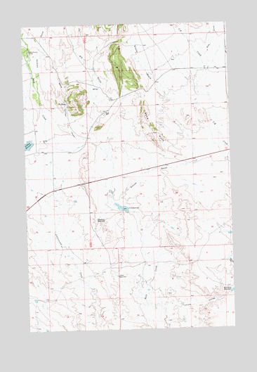
Hays SE, MT USGS Topographic Map
Click on map above to begin viewing in our Map Viewer.

This topographic map contains these locations and features:
Feature Name Type Latitude Longitude GNIS ID View Map
24N24E12CDDA01 SpringSpringN47.8430°W108.5996°825089View Map
24N24E25CB__01 WellWellN47.8039°W108.6063°824989View Map
24N24E25CBC_01 WellWellN47.8039°W108.6057°824988View Map
Chimney GulchValleyN47.8500°W108.6171°769838View Map
Dry GulchValleyN47.8064°W108.5726°770833View Map
Grouse GulchValleyN47.8047°W108.5676°772014View Map
Grouse Gulch School (historical)SchoolN47.8339°W108.5332°1721964View Map
J D ReservoirReservoirN47.7999°W108.5670°772750View Map
Kieth CouleeValleyN47.7647°W108.5007°773028View Map
Lazy J-D Number 1 DamDamN47.8000°W108.5640°796447View Map
Little Rockies CampLocaleN47.8644°W108.6215°773480View Map
Little Rocky Mountains Historical MarkerParkN47.8036°W108.6202°1721856View Map
McChesney ReservoirReservoirN47.7651°W108.5015°773966View Map
McChesney Reservoir DamDamN47.7650°W108.5024°798015View Map
Pearl ReservoirReservoirN47.7720°W108.5707°775124View Map
Ruby CreekStreamN47.8150°W108.5004°778780View Map
Sand HillsRidgeN47.8300°W108.5476°776196View Map
The PlungeLakeN47.8430°W108.5993°777529View Map
Warm Springs CreekStreamN47.8269°W108.5863°792833View Map
Waydown ReservoirReservoirN47.7953°W108.5826°778157View Map
Whitmore Spring CreekStreamN47.8189°W108.5035°1721835View Map

Note: Coordinates in the location and feature list above are referenced to NAD83 datum.


Copyright (C) 2008-2025 Ryan Niemi / Sunset Dynamics ... All Rights Reserved