TopoQuest Logo
Do you find TopoQuest useful?
Help keep TopoQuest running and adding new maps/features by donating!
Bitcoin:  19c7KJd3qBynnjoSw5npx9KScwjBe4ifkT
Litecoin:  LXs6TkuXGGXo1vDsWCkWVdjQX94eUKd6ui
Home View Maps Find Maps Find Places Resources & Links


Haywood, Oklahoma Topographic Map

USGS Map Title: Haywood, OK
USGS Map MRC: 34095H8
DRG (GeoTIFF) Download: o34095h8.tif


Neighboring USGS Topographic Map Quads:


  Wetumka SE, OK  
35096A1
 

  Scipio, OK  
35095A8
 

  Lake McAlester, OK  
35095A7
 

  Stuart, OK  
34096H1
 

  Haywood, OK  
34095H8
 

  McAlester, OK  
34095H7
 

  Ashland, OK  
34096G1
 

  McAlester SW, OK  
34095G8
 

  Savanna, OK  
34095G7


Map MRC Location:

N35°
W96°
N35°
W95°
H8 H7 H6 H5 H4 H3 H2 H1
G8 G7 G6 G5 G4 G3 G2 G1
F8 F7 F6 F5 F4 F3 F2 F1
E8 E7 E6 E5 E4 E3 E2 E1
D8 D7 D6 D5 D4 D3 D2 D1
C8 C7 C6 C5 C4 C3 C2 C1
B8 B7 B6 B5 B4 B3 B2 B1
A8 A7 A6 A5 A4 A3 A2 A1
N34°
W96°
N34°
W95°

Haywood, OK USGS 1:24K Topographic Map Preview:
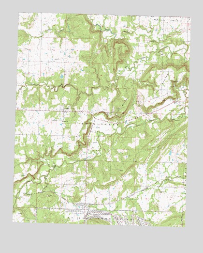
Haywood, OK USGS Topographic Map
Click on map above to begin viewing in our Map Viewer.

This topographic map contains these locations and features:
Feature Name Type Latitude Longitude GNIS ID View Map
ArpelarPopulated PlaceN34.9420°W95.9656°1089709View Map
Arpelar CemeteryCemeteryN34.9368°W95.9694°1089710View Map
Arpelar Census Designated PlaceCensusN34.9356°W95.9589°2629904View Map
Arpelar ChurchChurchN34.9359°W95.9661°1089711View Map
Blue CemeteryCemeteryN34.9444°W95.8859°1090271View Map
Blue ChurchChurchN34.9473°W95.8819°1090272View Map
Blue Volunteer Fire DepartmentBuildingN34.9478°W95.8822°2657429View Map
Christian Hill CemeteryCemeteryN34.8960°W95.8944°1091345View Map
Coon CreekStreamN34.9565°W95.8756°1091637View Map
Grubb MountainSummitN34.9426°W95.9228°1093430View Map
HaywoodPopulated PlaceN34.8873°W95.9483°1093625View Map
Haywood - Arpelar Volunteer Fire Department Station 1BuildingN34.8880°W95.9478°2657327View Map
Haywood - Arpelar Volunteer Fire Department Station 2BuildingN34.9410°W95.9653°2657329View Map
Haywood Elementary SchoolSchoolN34.8851°W95.9471°1790675View Map
Hickory Grove CemeteryCemeteryN34.8762°W95.9839°1093710View Map
Little Wildhorse CreekStreamN34.9806°W95.8989°1094866View Map
Northwest Pittsburg DivisionCivilN34.9842°W95.9829°1937808View Map
Oknoname 121009 DamDamN34.9168°W95.8803°1755551View Map
Oknoname 121009 ReservoirReservoirN34.9168°W95.8803°1755552View Map
Oknoname 121010 DamDamN34.9618°W95.9503°1755553View Map
Oknoname 121010 ReservoirReservoirN34.9618°W95.9503°1755554View Map
Pyle MountainSummitN34.9695°W95.8889°1096976View Map
Tannehill Volunteer Fire Department Main StationBuildingN34.9998°W95.8843°2657296View Map
Tannehill Volunteer Fire Department Substation 5BuildingN34.9897°W95.8947°2657311View Map
Township of BucklucksyCivilN34.9390°W95.8794°1824645View Map
Zion Missionary Baptist CemeteryCemeteryN34.9786°W95.8972°2712536View Map
Zion Missionary Baptist ChurchChurchN34.9790°W95.8958°1100077View Map

Note: Coordinates in the location and feature list above are referenced to NAD83 datum.


Copyright (C) 2008-2025 Ryan Niemi / Sunset Dynamics ... All Rights Reserved