TopoQuest Logo
Do you find TopoQuest useful?
Help keep TopoQuest running and adding new maps/features by donating!
Bitcoin:  19c7KJd3qBynnjoSw5npx9KScwjBe4ifkT
Litecoin:  LXs6TkuXGGXo1vDsWCkWVdjQX94eUKd6ui
Home View Maps Find Maps Find Places Resources & Links


Lake McAlester, Oklahoma Topographic Map

USGS Map Title: Lake McAlester, OK
USGS Map MRC: 35095A7
DRG (GeoTIFF) Download: o35095a7.tif


Neighboring USGS Topographic Map Quads:


  Hanna, OK  
35095B8
 

  Indianola, OK  
35095B7
 

  Canadian, OK  
35095B6
 

  Scipio, OK  
35095A8
 

  Lake McAlester, OK  
35095A7
 

  Crowder, OK  
35095A6
 

  Haywood, OK  
34095H8
 

  McAlester, OK  
34095H7
 

  Krebs, OK  
34095H6


Map MRC Location:

N36°
W96°
N36°
W95°
H8 H7 H6 H5 H4 H3 H2 H1
G8 G7 G6 G5 G4 G3 G2 G1
F8 F7 F6 F5 F4 F3 F2 F1
E8 E7 E6 E5 E4 E3 E2 E1
D8 D7 D6 D5 D4 D3 D2 D1
C8 C7 C6 C5 C4 C3 C2 C1
B8 B7 B6 B5 B4 B3 B2 B1
A8 A7 A6 A5 A4 A3 A2 A1
N35°
W96°
N35°
W95°

Lake McAlester, OK USGS 1:24K Topographic Map Preview:
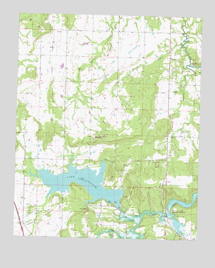
Lake McAlester, OK USGS Topographic Map
Click on map above to begin viewing in our Map Viewer.

This topographic map contains these locations and features:
Feature Name Type Latitude Longitude GNIS ID View Map
Bald MountainSummitN35.1048°W95.8114°1089812View Map
Bull CreekStreamN35.0123°W95.7886°1090665View Map
Camp CraigLocaleN35.0193°W95.8228°1090841View Map
Camp HudgensLocaleN35.0159°W95.8253°1090863View Map
Caston Mountain Creek Site 4 DamDamN35.0334°W95.7886°1752305View Map
Caston Mountain Creek Site 4 ReservoirReservoirN35.0322°W95.7891°1752306View Map
Lake McAlesterReservoirN35.0306°W95.8295°1095205View Map
Lake Mcalester DamDamN35.0184°W95.8036°1751144View Map
Medicine CreekStreamN35.1090°W95.7633°1095288View Map
MekkoPopulated PlaceN35.0001°W95.7539°1100625View Map
Mekko ChurchChurchN35.0004°W95.7625°1095300View Map
Mills Flying M Ranch Airport (historical)AirportN35.0568°W95.8214°1102543View Map
North Central Pittsburg DivisionCivilN35.1152°W95.7557°1937786View Map
Oknoname 121011 DamDamN35.0951°W95.8436°1755555View Map
Oknoname 121011 ReservoirReservoirN35.0959°W95.8451°1755556View Map
Oknoname 121020 DamDamN35.0984°W95.8736°1751788View Map
Oknoname 121020 ReservoirReservoirN35.0984°W95.8736°1751789View Map
Shady Grove CemeteryCemeteryN35.0600°W95.7632°1097935View Map
Shady Grove ChurchChurchN35.0576°W95.7694°1097941View Map
Shady Grove Volunteer Fire DepartmentBuildingN35.0337°W95.7738°2657322View Map
Tannehill PrairieFlatN35.0040°W95.8719°1098747View Map
Tannehill Volunteer Fire Department Substation 1BuildingN35.0293°W95.8024°2657508View Map
Tannehill Volunteer Fire Department Substation 2BuildingN35.0030°W95.8642°2657507View Map
Wildhorse CreekStreamN35.0976°W95.7572°1099791View Map

Note: Coordinates in the location and feature list above are referenced to NAD83 datum.


Copyright (C) 2008-2025 Ryan Niemi / Sunset Dynamics ... All Rights Reserved