TopoQuest Logo
Do you find TopoQuest useful?
Help keep TopoQuest running and adding new maps/features by donating!
Bitcoin:  19c7KJd3qBynnjoSw5npx9KScwjBe4ifkT
Litecoin:  LXs6TkuXGGXo1vDsWCkWVdjQX94eUKd6ui
Home View Maps Find Maps Find Places Resources & Links


Hebbronville, Texas Topographic Map

USGS Map Title: Hebbronville, TX
USGS Map MRC: 27098C6
DRG (GeoTIFF) Download: o27098c6.tif


Neighboring USGS Topographic Map Quads:


  Bruni, TX  
27098D7
 

  Hebbronville NW, TX  
27098D6
 

  Realitos, TX  
27098D5
 

  Bruni SE, TX  
27098C7
 

  Hebbronville, TX  
27098C6
 

  Hebbronville SE, TX  
27098C5
 

  Armstrong Ranch, TX  
27098B7
 

  McCampbell Ranch, TX  
27098B6
 

  Baluarte Ranch, TX  
27098B5


Map MRC Location:

N28°
W99°
N28°
W98°
H8 H7 H6 H5 H4 H3 H2 H1
G8 G7 G6 G5 G4 G3 G2 G1
F8 F7 F6 F5 F4 F3 F2 F1
E8 E7 E6 E5 E4 E3 E2 E1
D8 D7 D6 D5 D4 D3 D2 D1
C8 C7 C6 C5 C4 C3 C2 C1
B8 B7 B6 B5 B4 B3 B2 B1
A8 A7 A6 A5 A4 A3 A2 A1
N27°
W99°
N27°
W98°

Hebbronville, TX USGS 1:24K Topographic Map Preview:
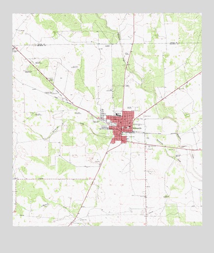
Hebbronville, TX USGS Topographic Map
Click on map above to begin viewing in our Map Viewer.

This topographic map contains these locations and features:
Feature Name Type Latitude Longitude GNIS ID View Map
Camino de Fierro Windmill Number 1LocaleN27.3281°W98.7242°1331933View Map
Camino de Fierro Windmill Number 2LocaleN27.3414°W98.7420°1331934View Map
Catholic ChurchChurchN27.3084°W98.6736°2022826View Map
Catoroe WindmillLocaleN27.3359°W98.7231°1332339View Map
Dos Casas Windmill Number OneLocaleN27.3167°W98.7089°1334507View Map
Dos Casas Windmill Number TwoLocaleN27.3159°W98.7353°1334508View Map
Dusty Downs RacetrackLocaleN27.3123°W98.6967°1384363View Map
El Monte WindmillLocaleN27.3561°W98.6889°1335217View Map
First Baptist ChurchChurchN27.3136°W98.6792°2022825View Map
Gravel WindmillLocaleN27.3517°W98.6756°1336867View Map
Gruy StadiumParkN27.3150°W98.6817°2027826View Map
HebbronvillePopulated PlaceN27.3067°W98.6784°1337545View Map
Hebbronville Assembly of God ChurchChurchN27.2998°W98.6809°2022824View Map
Hebbronville Census Designated PlaceCensusN27.3240°W98.6861°2408366View Map
Hebbronville Elementary SchoolSchoolN27.3150°W98.6795°2007149View Map
Hebbronville High SchoolSchoolN27.3181°W98.6792°2007150View Map
Hebbronville Junior High SchoolSchoolN27.3153°W98.6828°2007151View Map
Jim Hogg County AirportAirportN27.3516°W98.7409°1386801View Map
Jim Hogg County CourthouseBuildingN27.3087°W98.6781°2030592View Map
Jim Hogg County Fire Department Station 2BuildingN27.3068°W98.6770°2551180View Map
Jim Hogg County JailBuildingN27.3063°W98.6763°2738775View Map
Jim Hogg County Public LibraryBuildingN27.3081°W98.6786°2014882View Map
Jim Hogg County Sheriff's OfficeBuildingN27.3063°W98.6763°2750386View Map
KCFL-FM (Hebbronville)TowerN27.3175°W98.6670°1387988View Map
Las Flores Windmill Number OneLocaleN27.3439°W98.7070°1339662View Map
Las Flores Windmill Number TwoLocaleN27.3464°W98.7350°1339663View Map
Las LomitasPopulated PlaceN27.3417°W98.6642°1852727View Map
Las Lomitas A ColoniaPopulated PlaceN27.3553°W98.6684°2011493View Map
Las Lomitas B ColoniaPopulated PlaceN27.3342°W98.6722°2011494View Map
Las Lomitas C ColoniaPopulated PlaceN27.3523°W98.6684°2011495View Map
Las Lomitas Census Designated PlaceCensusN27.3378°W98.6629°2408580View Map
Loma Vista WindmillLocaleN27.2909°W98.6431°1340359View Map
New Hebbronville CemeteryCemeteryN27.2973°W98.6617°1342453View Map
Old Hebbronville CemeteryCemeteryN27.3098°W98.6653°1343161View Map
Pee Wee WindmillLocaleN27.3200°W98.6747°1343799View Map
Plato WindmillLocaleN27.2675°W98.6484°1344174View Map
Quality Care Ambulance ServiceBuildingN27.3129°W98.6872°2656140View Map
Saint James Episcopal ChurchChurchN27.3106°W98.6781°2022827View Map
South Fork ColoniaPopulated PlaceN27.2703°W98.7022°2011496View Map
South Fork EstatesPopulated PlaceN27.2695°W98.7061°1852769View Map
South Fork Estates Census Designated PlaceCensusN27.2697°W98.7240°2408764View Map
United States Border Patrol CheckpointBuildingN27.2966°W98.6629°2750827View Map
United States Border Patrol CheckpointBuildingN27.2829°W98.6935°2750828View Map
United States Border Patrol StationBuildingN27.3132°W98.6683°2750804View Map
Yeguas WindmillLocaleN27.3323°W98.6753°1350665View Map
Yeguas WindmillLocaleN27.3325°W98.6756°1350666View Map

Note: Coordinates in the location and feature list above are referenced to NAD83 datum.


Copyright (C) 2008-2025 Ryan Niemi / Sunset Dynamics ... All Rights Reserved