TopoQuest Logo
Do you find TopoQuest useful?
Help keep TopoQuest running and adding new maps/features by donating!
Bitcoin:  19c7KJd3qBynnjoSw5npx9KScwjBe4ifkT
Litecoin:  LXs6TkuXGGXo1vDsWCkWVdjQX94eUKd6ui
Home View Maps Find Maps Find Places Resources & Links


Hewitt Lake, Montana Topographic Map

USGS Map Title: Hewitt Lake, MT
USGS Map MRC: 48107E5
DRG (GeoTIFF) Download: o48107e5.tif


Neighboring USGS Topographic Map Quads:


  Austin Lake, MT  
48107F6
 

  Tattnall, MT  
48107F5
 

  Forks, MT  
48107F4
 

  Hewitt Lake SW, MT  
48107E6
 

  Hewitt Lake, MT  
48107E5
 

  Cole, MT  
48107E4
 

  Lake Bowdoin, MT  
48107D6
 

  Bowdoin, MT  
48107D5
 

  Robinson Ranch, MT  
48107D4


Map MRC Location:

N49°
W108°
N49°
W107°
H8 H7 H6 H5 H4 H3 H2 H1
G8 G7 G6 G5 G4 G3 G2 G1
F8 F7 F6 F5 F4 F3 F2 F1
E8 E7 E6 E5 E4 E3 E2 E1
D8 D7 D6 D5 D4 D3 D2 D1
C8 C7 C6 C5 C4 C3 C2 C1
B8 B7 B6 B5 B4 B3 B2 B1
A8 A7 A6 A5 A4 A3 A2 A1
N48°
W108°
N48°
W107°

Hewitt Lake, MT USGS 1:24K Topographic Map Preview:
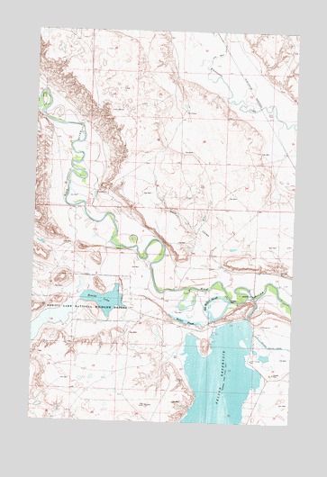
Hewitt Lake, MT USGS Topographic Map
Click on map above to begin viewing in our Map Viewer.

This topographic map contains these locations and features:
Feature Name Type Latitude Longitude GNIS ID View Map
Alkali CouleeValleyN48.5522°W107.5387°768170View Map
Big McNeil SloughReservoirN48.5335°W107.5364°768805View Map
Cree CrossingPopulated PlaceN48.5406°W107.5193°770291View Map
Cree Crossing School (historical)SchoolN48.5200°W107.5195°770292View Map
Denoma School (historical)SchoolN48.5822°W107.5109°1721883View Map
Hewitt DamDamN48.5383°W107.5840°795709View Map
Hewitt LakeReservoirN48.5387°W107.5908°772363View Map
Hewitt Lake National Wildlife RefugeParkN48.5349°W107.6104°772364View Map
Hymer CouleeValleyN48.6133°W107.5004°800196View Map
Joe Bell CouleeValleyN48.6153°W107.5426°802126View Map
McNeil SloughLakeN48.5326°W107.5522°774047View Map
Milk River Ford BridgeBridgeN48.5406°W107.5193°1721777View Map
Nelson CanalCanalN48.5367°W107.5193°774570View Map
Nelson Dikes A,B,C, and DDamN48.5283°W107.5173°795617View Map
Nelson Reservoir CampgroundLocaleN48.5153°W107.5056°1721921View Map
Nelson South CanalCanalN48.5244°W107.5115°774585View Map
Nichols (historical)LocaleN48.6019°W107.5193°1722034View Map
Oxarart DamDamN48.5392°W107.5304°775014View Map
Phillips County Waterfowl Production AreaParkN48.5442°W107.5870°2765573View Map
Shotgun CreekStreamN48.5961°W107.5012°1721844View Map

Note: Coordinates in the location and feature list above are referenced to NAD83 datum.


Copyright (C) 2008-2025 Ryan Niemi / Sunset Dynamics ... All Rights Reserved