TopoQuest Logo
Do you find TopoQuest useful?
Help keep TopoQuest running and adding new maps/features by donating!
Bitcoin:  19c7KJd3qBynnjoSw5npx9KScwjBe4ifkT
Litecoin:  LXs6TkuXGGXo1vDsWCkWVdjQX94eUKd6ui
Home View Maps Find Maps Find Places Resources & Links


Hickman, Ohio Topographic Map

USGS Map Title: Hickman, OH
USGS Map MRC: 40082B3
DRG (GeoTIFF) Download: o40082b3.tif


Neighboring USGS Topographic Map Quads:


  Hunt, OH  
40082C4
 

  Martinsburg, OH  
40082C3
 

  Walhonding, OH  
40082C2
 

  Utica, OH  
40082B4
 

  Hickman, OH  
40082B3
 

  Perryton, OH  
40082B2
 

  Newark, OH  
40082A4
 

  Hanover, OH  
40082A3
 

  Toboso, OH  
40082A2


Map MRC Location:

N41°
W83°
N41°
W82°
H8 H7 H6 H5 H4 H3 H2 H1
G8 G7 G6 G5 G4 G3 G2 G1
F8 F7 F6 F5 F4 F3 F2 F1
E8 E7 E6 E5 E4 E3 E2 E1
D8 D7 D6 D5 D4 D3 D2 D1
C8 C7 C6 C5 C4 C3 C2 C1
B8 B7 B6 B5 B4 B3 B2 B1
A8 A7 A6 A5 A4 A3 A2 A1
N40°
W83°
N40°
W82°

Hickman, OH USGS 1:24K Topographic Map Preview:
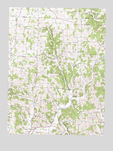
Hickman, OH USGS Topographic Map
Click on map above to begin viewing in our Map Viewer.

This topographic map contains these locations and features:
Feature Name Type Latitude Longitude GNIS ID View Map
Barnes CemeteryCemeteryN40.1285°W82.3478°1954708View Map
Boy Scout Memorial BridgeBridgeN40.1695°W82.2971°1052180View Map
Burrell ChapelChurchN40.1542°W82.2907°1070702View Map
Camp OhioLocaleN40.2295°W82.3260°1038731View Map
Camp WakatomikaLocaleN40.2334°W82.2624°1038760View Map
Concord School (historical)SchoolN40.2209°W82.3368°1052184View Map
East Branch Rocky ForkStreamN40.2392°W82.3618°1039972View Map
Eden ChurchChurchN40.2009°W82.3560°1064598View Map
Eden Church CemeteryCemeteryN40.2017°W82.3574°1954712View Map
Falling Rock CampLocaleN40.1806°W82.3032°1040378View Map
Falls Church School (historical)SchoolN40.2290°W82.2993°1052178View Map
Forest Glen Church (historical)ChurchN40.1881°W82.2640°1052176View Map
Freedom School (historical)SchoolN40.2259°W82.2665°1052175View Map
Henpeck CornersLocaleN40.2345°W82.2782°1064824View Map
HickmanPopulated PlaceN40.1498°W82.3096°1064830View Map
Hickman Post Office (historical)Post OfficeN40.1501°W82.3096°2026075View Map
Lake OttoReservoirN40.2019°W82.2511°1070884View Map
Lake Otto DamDamN40.2017°W82.2515°1078435View Map
Langley School (historical)SchoolN40.1523°W82.2957°1052181View Map
Long RunStreamN40.1656°W82.2929°1042754View Map
Long Run (historical)Populated PlaceN40.2065°W82.2854°1071084View Map
Long Run ChurchChurchN40.2067°W82.2846°1042763View Map
Longrun Post Office (historical)Post OfficeN40.2070°W82.2860°2026305View Map
Lost RunStreamN40.1373°W82.3449°1065877View Map
Mary Ann Elementary SchoolSchoolN40.1267°W82.3368°1081624View Map
Mary Ann Township Volunteer Fire DepartmentBuildingN40.1304°W82.3435°2549885View Map
Miles Chapel (historical)ChurchN40.1823°W82.3249°1052179View Map
Miles Chapel CemeteryCemeteryN40.1834°W82.3249°1043308View Map
Painter RunStreamN40.1576°W82.2971°1066132View Map
Pleasant Hill School (historical)SchoolN40.1601°W82.3438°1052185View Map
Pleasant ValleyValleyN40.1598°W82.3421°1044589View Map
Pleasant View ChurchChurchN40.1278°W82.3460°1070903View Map
PurityPopulated PlaceN40.2003°W82.3385°1044801View Map
Purity Post Office (historical)Post OfficeN40.2001°W82.3388°2026267View Map
Rain RockPopulated PlaceN40.1928°W82.2896°1066161View Map
ReformPopulated PlaceN40.1367°W82.2501°1057951View Map
Reform Post Office (historical)Post OfficeN40.1362°W82.2513°2026301View Map
Rocky ForkPopulated PlaceN40.1628°W82.2913°1057964View Map
Rocky Fork CemeteryCemeteryN40.1512°W82.3085°1954801View Map
Rocky Fork Post Office (historical)Post OfficeN40.1626°W82.2915°2026270View Map
Smith ChapelChurchN40.1256°W82.2515°1065336View Map
Smith Chapel CemeteryCemeteryN40.1259°W82.2518°1071337View Map
Smokyrow RunStreamN40.1367°W82.3449°1046391View Map
Souslin CemeteryCemeteryN40.1909°W82.2994°1046437View Map
Township of EdenCivilN40.2053°W82.3240°1086455View Map
Township of Mary AnnCivilN40.1357°W82.3278°1086471View Map
Trapp School (historical)SchoolN40.2248°W82.3652°1052183View Map
Walsh Christmas Tree FarmLocaleN40.2006°W82.3725°2647909View Map
Wild Cherry School (historical)SchoolN40.1362°W82.3193°1052182View Map
Wilkins Post Office (historical)Post OfficeN40.1292°W82.3443°2026307View Map
Wilkins RunPopulated PlaceN40.1298°W82.3440°1061780View Map
Wilkins RunStreamN40.1298°W82.3379°1048306View Map
Willey School (historical)SchoolN40.1542°W82.2540°1052177View Map

Note: Coordinates in the location and feature list above are referenced to NAD83 datum.


Copyright (C) 2008-2025 Ryan Niemi / Sunset Dynamics ... All Rights Reserved