TopoQuest Logo
Do you find TopoQuest useful?
Help keep TopoQuest running and adding new maps/features by donating!
Bitcoin:  19c7KJd3qBynnjoSw5npx9KScwjBe4ifkT
Litecoin:  LXs6TkuXGGXo1vDsWCkWVdjQX94eUKd6ui
Home View Maps Find Maps Find Places Resources & Links


Babbitt, Minnesota Topographic Map

USGS Map Title: Babbitt, MN
USGS Map MRC: 47091F8
DRG (GeoTIFF) Download: o47091f8.tif


Neighboring USGS Topographic Map Quads:


  Eagles Nest, MN  
47092G1
 

  Bear Island, MN  
47091G8
 

  Kangas Bay, MN  
47091G7
 

  Isaac Lake, MN  
47092F1
 

  Babbitt, MN  
47091F8
 

  Babbitt NE, MN  
47091F7
 

  Allen, MN  
47092E1
 

  Babbitt SW, MN  
47091E8
 

  Babbitt SE, MN  
47091E7


Map MRC Location:

N48°
W92°
N48°
W91°
H8 H7 H6 H5 H4 H3 H2 H1
G8 G7 G6 G5 G4 G3 G2 G1
F8 F7 F6 F5 F4 F3 F2 F1
E8 E7 E6 E5 E4 E3 E2 E1
D8 D7 D6 D5 D4 D3 D2 D1
C8 C7 C6 C5 C4 C3 C2 C1
B8 B7 B6 B5 B4 B3 B2 B1
A8 A7 A6 A5 A4 A3 A2 A1
N47°
W92°
N47°
W91°

Babbitt, MN USGS 1:24K Topographic Map Preview:
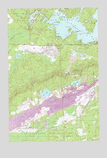
Babbitt, MN USGS Topographic Map
Click on map above to begin viewing in our Map Viewer.

This topographic map contains these locations and features:
Feature Name Type Latitude Longitude GNIS ID View Map
Aikio IslandIslandN47.7363°W91.9288°660634View Map
Argo LakeLakeN47.6802°W91.9068°660669View Map
BabbittPopulated PlaceN47.7085°W91.9446°660701View Map
Babbitt Ambulance ServiceBuildingN47.7137°W91.9441°2721227View Map
Babbitt Assembly of God ChurchChurchN47.7097°W91.9519°2126434View Map
Babbitt Baptist ChurchChurchN47.7125°W91.9397°2126437View Map
Babbitt City HallBuildingN47.7086°W91.9444°2126423View Map
Babbitt High SchoolSchoolN47.7081°W91.9508°2126429View Map
Babbitt Police DepartmentBuildingN47.7077°W91.9395°2126426View Map
Babbitt Post OfficePost OfficeN47.7133°W91.9486°2126427View Map
Babbitt Public LibraryBuildingN47.7078°W91.9417°2126425View Map
Babbitt Volunteer Fire DepartmentBuildingN47.7137°W91.9439°2126424View Map
Beaver PondLakeN47.7149°W91.9417°660762View Map
Birch Lake and CampgroundsLocaleN47.7153°W91.9092°2126422View Map
Birch RiverStreamN47.7382°W91.9438°660814View Map
Birch River NarrowsChannelN47.7444°W91.9557°662026View Map
Blueberry IslandIslandN47.7277°W91.9054°660839View Map
Blueberry Island ReefBarN47.7257°W91.9010°660842View Map
Butterfly LakeLakeN47.7023°W91.9412°660924View Map
Camp RivardLocaleN47.7427°W91.9382°660947View Map
City of BabbittCivilN47.6446°W91.9457°2394047View Map
Deer IslandIslandN47.7291°W91.9138°661108View Map
Dollar Hide BayBayN47.7352°W91.8774°661124View Map
Duluth Clinic-BabbittHospitalN47.7147°W91.9486°2126428View Map
Eagle Nest PointCapeN47.7410°W91.9196°661158View Map
Evangelical Lutheran ChurchChurchN47.7106°W91.9478°2126439View Map
Finn BayBayN47.7249°W91.9310°661270View Map
First Test Pit on the Mesabi Historical MarkerParkN47.7153°W91.9889°2126624View Map
Good Shepherd Lutheran ChurchChurchN47.7122°W91.9550°2126435View Map
Hay LakeLakeN47.7096°W91.9739°661446View Map
Iron LakeLakeN47.6705°W91.9492°661553View Map
Kramer BayBayN47.7319°W91.9377°661664View Map
Kramer PointCapeN47.7341°W91.9360°661665View Map
Marsyla ReefBarN47.7321°W91.9143°661870View Map
Minnow LakeLakeN47.7208°W91.9326°661928View Map
Moose PointCapeN47.7257°W91.8868°661957View Map
Mud LakeLakeN47.7055°W91.9857°661994View Map
Saint Pius Catholic ChurchChurchN47.7092°W91.9506°2126436View Map
Snowshoe BayBayN47.7419°W91.9013°662487View Map
West BayBayN47.7402°W91.8827°662764View Map
Whisper LakeLakeN47.7498°W91.9238°662786View Map
Woodland Presbyterian ChurchChurchN47.7119°W91.9478°2126438View Map
Yelp CreekStreamN47.6283°W91.9771°660519View Map

Note: Coordinates in the location and feature list above are referenced to NAD83 datum.


Copyright (C) 2008-2025 Ryan Niemi / Sunset Dynamics ... All Rights Reserved