TopoQuest Logo
Do you find TopoQuest useful?
Help keep TopoQuest running and adding new maps/features by donating!
Bitcoin:  19c7KJd3qBynnjoSw5npx9KScwjBe4ifkT
Litecoin:  LXs6TkuXGGXo1vDsWCkWVdjQX94eUKd6ui
Home View Maps Find Maps Find Places Resources & Links


Hillside, Arizona Topographic Map

USGS Map Title: Hillside, AZ
USGS Map MRC: 34112D8
DRG (GeoTIFF) Download: o34112d8.tif


Neighboring USGS Topographic Map Quads:


  Big Shipp Mountain, AZ  
34113E1
 

  Muleshoe Ranch, AZ  
34112E8
 

  Martin Mountain, AZ  
34112E7
 

  Malpais Mesa NE, AZ  
34113D1
 

  Hillside, AZ  
34112D8
 

  Bismarck Mesa, AZ  
34112D7
 

  Malpais Mesa, AZ  
34113C1
 

  Date, AZ  
34112C8
 

  Weaver Peak, AZ  
34112C7


Map MRC Location:

N35°
W113°
N35°
W112°
H8 H7 H6 H5 H4 H3 H2 H1
G8 G7 G6 G5 G4 G3 G2 G1
F8 F7 F6 F5 F4 F3 F2 F1
E8 E7 E6 E5 E4 E3 E2 E1
D8 D7 D6 D5 D4 D3 D2 D1
C8 C7 C6 C5 C4 C3 C2 C1
B8 B7 B6 B5 B4 B3 B2 B1
A8 A7 A6 A5 A4 A3 A2 A1
N34°
W113°
N34°
W112°

Hillside, AZ USGS 1:24K Topographic Map Preview:
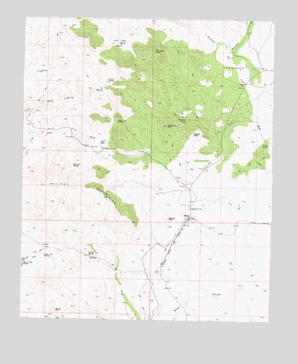
Hillside, AZ USGS Topographic Map
Click on map above to begin viewing in our Map Viewer.

This topographic map contains these locations and features:
Feature Name Type Latitude Longitude GNIS ID View Map
Ally WashStreamN34.4670°W112.8877°609View Map
Bismark MountainSummitN34.4831°W112.9421°21181View Map
Bland CreekStreamN34.4725°W112.8882°1672View Map
Carter FlatFlatN34.4053°W112.9882°2492View Map
Carter Flat SpringSpringN34.4014°W112.9885°2493View Map
Chartz SpringSpringN34.4484°W112.8780°2772View Map
Eastwood CreekStreamN34.4895°W112.9032°28805View Map
HillsidePopulated PlaceN34.4184°W112.9171°24459View Map
Hillside Elementary SchoolSchoolN34.4214°W112.9157°2543523View Map
Hillside PeakSummitN34.4172°W112.9269°5823View Map
Hillside Railroad StationBuildingN34.4172°W112.9169°21287View Map
Hoover Dam SpringSpringN34.3978°W112.9994°5929View Map
Kingsbury MountainSummitN34.4559°W112.9282°6707View Map
Kingsbury SpringSpringN34.4581°W112.9191°6708View Map
Laurel SpringSpringN34.4736°W112.9577°6908View Map
Lawler SpringSpringN34.4017°W112.9669°6924View Map
McCloud MountainsSummitN34.4292°W112.9624°7812View Map
McCloud SpringSpringN34.4388°W112.9752°7813View Map
Mine TankReservoirN34.4482°W112.9618°8093View Map
Quail SpringSpringN34.4570°W112.9507°9843View Map
Sadies PeakSummitN34.4522°W112.9152°10656View Map
Sweetwater WellWellN34.4775°W112.9924°12057View Map
Thompson PeakSummitN34.4872°W112.9352°12399View Map
Thompson ValleyValleyN34.4792°W112.9132°12406View Map
Thompson Valley SchoolSchoolN34.4217°W112.9155°12407View Map
Wild Hog BasinBasinN34.4897°W112.9532°13762View Map
YavaPopulated PlaceN34.4720°W112.8905°24697View Map

Note: Coordinates in the location and feature list above are referenced to NAD83 datum.


Copyright (C) 2008-2025 Ryan Niemi / Sunset Dynamics ... All Rights Reserved