TopoQuest Logo
Do you find TopoQuest useful?
Help keep TopoQuest running and adding new maps/features by donating!
Bitcoin:  19c7KJd3qBynnjoSw5npx9KScwjBe4ifkT
Litecoin:  LXs6TkuXGGXo1vDsWCkWVdjQX94eUKd6ui
Home View Maps Find Maps Find Places Resources & Links


Hobgood, North Carolina Topographic Map

USGS Map Title: Hobgood, NC
USGS Map MRC: 36077A4
DRG (GeoTIFF) Download: o36077a4.tif


Neighboring USGS Topographic Map Quads:


  Dawson Crossroads, NC  
36077B5
 

  Scotland Neck, NC  
36077B4
 

  Norfleet, NC  
36077B3
 

  Draughn, NC  
36077A5
 

  Hobgood, NC  
36077A4
 

  Palmyra, NC  
36077A3
 

  Tarboro, NC  
35077H5
 

  Speed, NC  
35077H4
 

  Oak City, NC  
35077H3


Map MRC Location:

N37°
W78°
N37°
W77°
H8 H7 H6 H5 H4 H3 H2 H1
G8 G7 G6 G5 G4 G3 G2 G1
F8 F7 F6 F5 F4 F3 F2 F1
E8 E7 E6 E5 E4 E3 E2 E1
D8 D7 D6 D5 D4 D3 D2 D1
C8 C7 C6 C5 C4 C3 C2 C1
B8 B7 B6 B5 B4 B3 B2 B1
A8 A7 A6 A5 A4 A3 A2 A1
N36°
W78°
N36°
W77°

Hobgood, NC USGS 1:24K Topographic Map Preview:
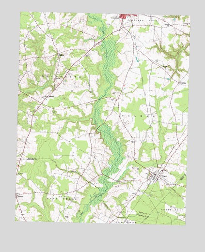
Hobgood, NC USGS Topographic Map
Click on map above to begin viewing in our Map Viewer.

This topographic map contains these locations and features:
Feature Name Type Latitude Longitude GNIS ID View Map
Bell CemeteryCemeteryN36.0329°W77.4111°980933View Map
Bland CemeteryCemeteryN36.0267°W77.4140°981585View Map
Braswells CrossroadsPopulated PlaceN36.0849°W77.3819°1006139View Map
CharlestonPopulated PlaceN36.1202°W77.3755°1019605View Map
Cherry ChurchChurchN36.0174°W77.4011°983073View Map
Cobb CemeteryCemeteryN36.1101°W77.4930°983314View Map
East Pork FarmsLocaleN36.1019°W77.3953°2650342View Map
Edwards ForkPopulated PlaceN36.1190°W77.3889°1006194View Map
End Street ChurchChurchN36.0935°W77.3922°984783View Map
Grace ChurchChurchN36.0160°W77.4989°985895View Map
Gray CemeteryCemeteryN36.0785°W77.4614°985985View Map
Hardy CemeteryCemeteryN36.0649°W77.4730°986397View Map
Harrison CemeteryCemeteryN36.0204°W77.4975°986459View Map
HobgoodPopulated PlaceN36.0299°W77.3977°1020786View Map
Hobgood Post OfficePost OfficeN36.0309°W77.3993°2773824View Map
Hobgood Volunteer Fire DepartmentBuildingN36.0299°W77.3973°2638488View Map
Hogun CemeteryCemeteryN36.0404°W77.4164°986912View Map
Hyde CemeteryCemeteryN36.0074°W77.4536°987310View Map
Indian BranchStreamN36.0146°W77.4414°987334View Map
James CemeteryCemeteryN36.0318°W77.3930°987512View Map
James CemeteryCemeteryN36.0485°W77.4143°987513View Map
Joyner CemeteryCemeteryN36.0260°W77.4214°987794View Map
Joyner CemeteryCemeteryN36.0999°W77.4511°987795View Map
Kehukee ChurchChurchN36.1060°W77.4144°987889View Map
LawrencePopulated PlaceN36.0143°W77.4989°988221View Map
Leggett House CemeteryCemeteryN36.0776°W77.4305°988335View Map
Long ChurchChurchN36.0185°W77.4111°988940View Map
Manning CemeteryCemeteryN36.0035°W77.4600°989280View Map
Manning CemeteryCemeteryN36.0790°W77.4464°989281View Map
Marsh SwampStreamN36.0154°W77.4411°989373View Map
Meetinghouse ChurchChurchN36.0285°W77.4986°989707View Map
Mizell CemeteryCemeteryN36.0740°W77.4291°990109View Map
Mullins CrossroadsPopulated PlaceN36.1004°W77.4714°1006307View Map
Nahalah ChurchChurchN36.0660°W77.4869°990838View Map
Pleasant Hill ChurchChurchN36.0854°W77.4730°992539View Map
RoseneathPopulated PlaceN36.0749°W77.4783°1006355View Map
Shield SchoolSchoolN36.0327°W77.3925°994676View Map
Staton CemeteryCemeteryN36.0968°W77.3975°995443View Map
Town of HobgoodCivilN36.0267°W77.3940°2405844View Map
Township of RoseneathCivilN36.0786°W77.4785°1026757View Map
Whitehead CemeteryCemeteryN36.0327°W77.4466°997223View Map
Whitehead CemeteryCemeteryN36.0885°W77.4641°997224View Map

Note: Coordinates in the location and feature list above are referenced to NAD83 datum.


Copyright (C) 2008-2025 Ryan Niemi / Sunset Dynamics ... All Rights Reserved