TopoQuest Logo
Do you find TopoQuest useful?
Help keep TopoQuest running and adding new maps/features by donating!
Bitcoin:  19c7KJd3qBynnjoSw5npx9KScwjBe4ifkT
Litecoin:  LXs6TkuXGGXo1vDsWCkWVdjQX94eUKd6ui
Home View Maps Find Maps Find Places Resources & Links


Holdenville, Oklahoma Topographic Map

USGS Map Title: Holdenville, OK
USGS Map MRC: 35096A4
DRG (GeoTIFF) Download: o35096a4.tif


Neighboring USGS Topographic Map Quads:


  Wewoka West, OK  
35096B5
 

  Wewoka East, OK  
35096B4
 

  Yeager, OK  
35096B3
 

  Tate Mountain, OK  
35096A5
 

  Holdenville, OK  
35096A4
 

  Lake Holdenville, OK  
35096A3
 

  Sasakwa, OK  
34096H5
 

  Allen, OK  
34096H4
 

  Calvin West, OK  
34096H3


Map MRC Location:

N36°
W97°
N36°
W96°
H8 H7 H6 H5 H4 H3 H2 H1
G8 G7 G6 G5 G4 G3 G2 G1
F8 F7 F6 F5 F4 F3 F2 F1
E8 E7 E6 E5 E4 E3 E2 E1
D8 D7 D6 D5 D4 D3 D2 D1
C8 C7 C6 C5 C4 C3 C2 C1
B8 B7 B6 B5 B4 B3 B2 B1
A8 A7 A6 A5 A4 A3 A2 A1
N35°
W97°
N35°
W96°

Holdenville, OK USGS 1:24K Topographic Map Preview:
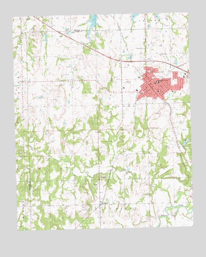
Holdenville, OK USGS Topographic Map
Click on map above to begin viewing in our Map Viewer.

This topographic map contains these locations and features:
Feature Name Type Latitude Longitude GNIS ID View Map
Big Wewoka Creek Site 30 DamDamN35.1151°W96.4770°1750936View Map
Big Wewoka Creek Site 30 ReservoirReservoirN35.1151°W96.4770°1750937View Map
Big Wewoka Creek Site 37 DamDamN35.1151°W96.3903°1750944View Map
Big Wewoka Creek Site 37 ReservoirReservoirN35.1151°W96.3903°1750945View Map
Bird CreekStreamN35.0118°W96.3889°1090154View Map
Buchner Memorial CemeteryCemeteryN35.1009°W96.3967°1090599View Map
Cedar River CemeteryCemeteryN35.0433°W96.4069°2711567View Map
Cedar River ChurchChurchN35.0445°W96.4081°1091131View Map
City of HoldenvilleCivilN35.0836°W96.4005°2410774View Map
Davis Correctional FacilityBuildingN35.0889°W96.4439°2766636View Map
Ed Perry 1 DamDamN35.0301°W96.4136°1754162View Map
Ed Perry 1 ReservoirReservoirN35.0301°W96.4136°1754163View Map
Ed Perry 2 DamDamN35.0184°W96.4120°1754164View Map
Ed Perry 2 ReservoirReservoirN35.0184°W96.4120°1754165View Map
Episcopal ChurchChurchN35.0834°W96.3992°1798349View Map
Ethel Reed Elementary SchoolSchoolN35.0785°W96.4094°1096438View Map
First Baptist ChurchChurchN35.0840°W96.3997°1798350View Map
First Christian ChurchChurchN35.0843°W96.3983°1798351View Map
First Church of GodChurchN35.0781°W96.3972°1798352View Map
HoldenvillePopulated PlaceN35.0804°W96.3992°1093837View Map
Holdenville CemeteryCemeteryN35.0901°W96.3991°2571591View Map
Holdenville Fire DepartmentBuildingN35.0842°W96.4023°2656970View Map
Holdenville General HospitalHospitalN35.0890°W96.3787°2695687View Map
Holdenville General Hospital HeliportAirportN35.0890°W96.3786°1102504View Map
Holdenville High SchoolSchoolN35.0846°W96.3976°1793712View Map
Holdenville Junior High SchoolSchoolN35.0793°W96.3978°1793713View Map
Holdenville Municipal AirportAirportN35.0865°W96.4144°1102503View Map
Holdenville Police DepartmentBuildingN35.0839°W96.4022°2757616View Map
Holdenville Waterworks DamDamN35.0484°W96.3803°1751544View Map
Holdenville Waterworks LakeReservoirN35.0493°W96.3794°1751545View Map
Hughes County Emergency Medical Services Station 1 HeadquartersBuildingN35.0815°W96.4010°2695891View Map
Hughes County JailBuildingN35.0841°W96.4001°2757833View Map
Hughes County Sheriff's OfficeBuildingN35.0841°W96.3999°2757438View Map
Jacobs CemeteryCemeteryN35.0844°W96.4575°2711586View Map
KRAF-AM (Holdenville)TowerN35.0568°W96.3806°1102762View Map
KUHD-FM (Holdenville)TowerN35.0568°W96.3806°1102804View Map
Leonard-Werner LakeReservoirN35.0034°W96.3936°1754399View Map
Leonard-Werner Lake Number 2 DamDamN35.0034°W96.3936°1754398View Map
Lynn Peters DamDamN35.0218°W96.3953°1754158View Map
Lynn Peters ReservoirReservoirN35.0211°W96.3957°1754159View Map
Middle Creek CemeteryCemeteryN35.0878°W96.4589°2747462View Map
Middle Creek ChurchChurchN35.0876°W96.4578°1095352View Map
Midway ChurchChurchN35.0873°W96.4939°1095378View Map
Oakwood CemeteryCemeteryN35.1234°W96.4925°1096168View Map
Oknoname 063023 DamDamN35.0767°W96.4803°1752965View Map
Oknoname 063023 ReservoirReservoirN35.0767°W96.4803°1752966View Map
Penn West Baptist ChurchChurchN35.0798°W96.4047°1798353View Map
Potato HillSummitN35.0298°W96.4375°1096869View Map
Shawnego CemeteryCemeteryN35.0692°W96.4350°2711588View Map
SpauldingPopulated PlaceN35.0140°W96.4400°1098340View Map
Spaulding Volunteer Fire DepartmentBuildingN35.0111°W96.4410°2657261View Map
Stroup ParkParkN35.0873°W96.3953°1098589View Map
Thomas Middle SchoolSchoolN35.0790°W96.3878°1098852View Map
Town of SpauldingCivilN35.0132°W96.4406°2413313View Map
United Pentecostal ChurchChurchN35.0804°W96.3995°1798354View Map

Note: Coordinates in the location and feature list above are referenced to NAD83 datum.


Copyright (C) 2008-2025 Ryan Niemi / Sunset Dynamics ... All Rights Reserved