TopoQuest Logo
Do you find TopoQuest useful?
Help keep TopoQuest running and adding new maps/features by donating!
Bitcoin:  19c7KJd3qBynnjoSw5npx9KScwjBe4ifkT
Litecoin:  LXs6TkuXGGXo1vDsWCkWVdjQX94eUKd6ui
Home View Maps Find Maps Find Places Resources & Links


Allen, Oklahoma Topographic Map

USGS Map Title: Allen, OK
USGS Map MRC: 34096H4
DRG (GeoTIFF) Download: o34096h4.tif


Neighboring USGS Topographic Map Quads:


  Tate Mountain, OK  
35096A5
 

  Holdenville, OK  
35096A4
 

  Lake Holdenville, OK  
35096A3
 

  Sasakwa, OK  
34096H5
 

  Allen, OK  
34096H4
 

  Calvin West, OK  
34096H3
 

  Francis, OK  
34096G5
 

  Steedman, OK  
34096G4
 

  Gerty, OK  
34096G3


Map MRC Location:

N35°
W97°
N35°
W96°
H8 H7 H6 H5 H4 H3 H2 H1
G8 G7 G6 G5 G4 G3 G2 G1
F8 F7 F6 F5 F4 F3 F2 F1
E8 E7 E6 E5 E4 E3 E2 E1
D8 D7 D6 D5 D4 D3 D2 D1
C8 C7 C6 C5 C4 C3 C2 C1
B8 B7 B6 B5 B4 B3 B2 B1
A8 A7 A6 A5 A4 A3 A2 A1
N34°
W97°
N34°
W96°

Allen, OK USGS 1:24K Topographic Map Preview:
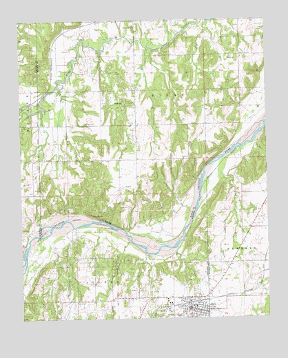
Allen, OK USGS Topographic Map
Click on map above to begin viewing in our Map Viewer.

This topographic map contains these locations and features:
Feature Name Type Latitude Longitude GNIS ID View Map
AllenPopulated PlaceN34.8790°W96.4125°1089584View Map
Allen CemeteryCemeteryN34.8778°W96.4164°2711548View Map
Allen Elementary SchoolSchoolN34.8799°W96.4127°1803811View Map
Allen High SchoolSchoolN34.8798°W96.4122°1803801View Map
Allen Oil FieldOilfieldN34.8962°W96.4367°1089588View Map
Allen Police DepartmentBuildingN34.8801°W96.4145°2757798View Map
Allen Volunteer Fire DepartmentBuildingN34.8798°W96.4146°2656843View Map
Arbeca CreekStreamN34.9404°W96.4014°1089680View Map
Baker BranchStreamN34.9195°W96.3920°1089791View Map
Boy Scout Camp DamDamN34.9168°W96.4570°1754160View Map
Boy Scout Camp ReservoirReservoirN34.9168°W96.4570°1754161View Map
Camp SasakwaLocaleN34.9184°W96.4589°1090876View Map
Greenleaf CemeteryCemeteryN34.9573°W96.4678°1093387View Map
Holdenville Oil FieldOilfieldN34.9743°W96.4717°1093838View Map
Leonard Wemer DamDamN34.9984°W96.3986°1754166View Map
Leonard Wemer ReservoirReservoirN34.9984°W96.3986°1754167View Map
Little River HillSummitN34.9970°W96.4411°1094807View Map
McCall SchoolSchoolN34.8820°W96.4722°1095208View Map
Oknoname 063002 DamDamN34.8834°W96.3903°1752923View Map
Oknoname 063002 ReservoirReservoirN34.8834°W96.3903°1752924View Map
Oknoname 063037 DamDamN34.9384°W96.3753°1750934View Map
Osage HillSummitN34.9656°W96.4481°1096316View Map
R W Borders DamDamN34.8784°W96.3820°1754134View Map
R W Borders ReservoirReservoirN34.8784°W96.3820°1754135View Map
Tiger CemeteryCemeteryN34.9567°W96.4714°2711590View Map
Town of AllenCivilN34.8774°W96.4130°2412349View Map
Township of BilbyCivilN34.9945°W96.3808°1824953View Map
Wemer-Leonard Company Lake Number 1ReservoirN34.9956°W96.3918°1754395View Map
Wemer-Leonard Company Lake Number 1 DamDamN34.9968°W96.3920°1754394View Map

Note: Coordinates in the location and feature list above are referenced to NAD83 datum.


Copyright (C) 2008-2024 Ryan Niemi / Sunset Dynamics ... All Rights Reserved