TopoQuest Logo
Do you find TopoQuest useful?
Help keep TopoQuest running and adding new maps/features by donating!
Bitcoin:  19c7KJd3qBynnjoSw5npx9KScwjBe4ifkT
Litecoin:  LXs6TkuXGGXo1vDsWCkWVdjQX94eUKd6ui
Home View Maps Find Maps Find Places Resources & Links


Holliday, Texas Topographic Map

USGS Map Title: Holliday, TX
USGS Map MRC: 33098G6
DRG (GeoTIFF) Download: o33098g6.tif


Neighboring USGS Topographic Map Quads:


  Fowlkes, TX  
33098H7
 

  Iowa Park, TX  
33098H6
 

  Wichita Falls West, TX  
33098H5
 

  Mankins, TX  
33098G7
 

  Holliday, TX  
33098G6
 

  Lake Wichita, TX  
33098G5
 

  Lake Kickapoo, TX  
33098F7
 

  Dads Corner, TX  
33098F6
 

  Archer City NE, TX  
33098F5


Map MRC Location:

N34°
W99°
N34°
W98°
H8 H7 H6 H5 H4 H3 H2 H1
G8 G7 G6 G5 G4 G3 G2 G1
F8 F7 F6 F5 F4 F3 F2 F1
E8 E7 E6 E5 E4 E3 E2 E1
D8 D7 D6 D5 D4 D3 D2 D1
C8 C7 C6 C5 C4 C3 C2 C1
B8 B7 B6 B5 B4 B3 B2 B1
A8 A7 A6 A5 A4 A3 A2 A1
N33°
W99°
N33°
W98°

Holliday, TX USGS 1:24K Topographic Map Preview:
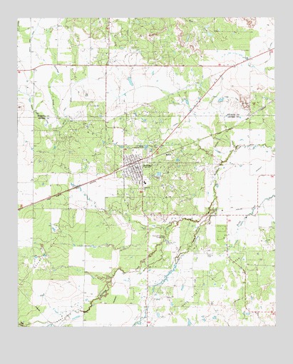
Holliday, TX USGS Topographic Map
Click on map above to begin viewing in our Map Viewer.

This topographic map contains these locations and features:
Feature Name Type Latitude Longitude GNIS ID View Map
Bull CreekStreamN33.7501°W98.7476°1353238View Map
CA LateralCanalN33.8304°W98.6759°1353484View Map
Cactus Hill AirportAirportN33.8701°W98.6455°2675791View Map
City of HollidayCivilN33.8141°W98.6899°2410776View Map
Daume Oil FieldOilfieldN33.7784°W98.7356°1355662View Map
Gose Oil FieldOilfieldN33.7534°W98.7267°1358204View Map
HartexPopulated PlaceN33.8207°W98.6773°1379901View Map
HollidayPopulated PlaceN33.8162°W98.6951°1359420View Map
Holliday City OfficeBuildingN33.8160°W98.6960°2753148View Map
Holliday Elementary SchoolSchoolN33.8084°W98.6903°2002993View Map
Holliday High SchoolSchoolN33.8084°W98.6903°2002994View Map
Holliday Middle SchoolSchoolN33.8084°W98.6903°2002995View Map
Holliday Oil FieldOilfieldN33.8198°W98.6889°1359423View Map
Holliday Police DepartmentBuildingN33.8160°W98.6961°2750382View Map
Holliday Post OfficePost OfficeN33.8138°W98.6932°2731562View Map
Holliday Volunteer Fire DepartmentBuildingN33.8116°W98.6933°2552079View Map
Hull-Silk Oil FieldOilfieldN33.7718°W98.6481°1374174View Map
Lake Kickapoo Volunteer Fire DepartmentBuildingN33.8639°W98.7062°2551165View Map
Lucky G AirportAirportN33.8530°W98.6465°1386824View Map
Netherly LakeReservoirN33.8679°W98.7126°1864853View Map
Netherly Lake DamDamN33.8668°W98.7120°1864852View Map
Panther CreekStreamN33.7973°W98.6567°1364782View Map
Stonewall Jackson CampgroundLocaleN33.7868°W98.6789°1369246View Map
SZ LateralCanalN33.8690°W98.6964°1367077View Map
Wichita West Volunteer Fire DepartmentBuildingN33.8626°W98.6265°2552065View Map

Note: Coordinates in the location and feature list above are referenced to NAD83 datum.


Copyright (C) 2008-2025 Ryan Niemi / Sunset Dynamics ... All Rights Reserved