TopoQuest Logo
Do you find TopoQuest useful?
Help keep TopoQuest running and adding new maps/features by donating!
Bitcoin:  19c7KJd3qBynnjoSw5npx9KScwjBe4ifkT
Litecoin:  LXs6TkuXGGXo1vDsWCkWVdjQX94eUKd6ui
Home View Maps Find Maps Find Places Resources & Links


Iowa Park, Texas Topographic Map

USGS Map Title: Iowa Park, TX
USGS Map MRC: 33098H6
DRG (GeoTIFF) Download: o33098h6.tif


Neighboring USGS Topographic Map Quads:


  Sunshine Hill, TX  
34098A7
 

  Clara, TX  
34098A6
 

  Burkburnett, TX  
34098A5
 

  Fowlkes, TX  
33098H7
 

  Iowa Park, TX  
33098H6
 

  Wichita Falls West, TX  
33098H5
 

  Mankins, TX  
33098G7
 

  Holliday, TX  
33098G6
 

  Lake Wichita, TX  
33098G5


Map MRC Location:

N34°
W99°
N34°
W98°
H8 H7 H6 H5 H4 H3 H2 H1
G8 G7 G6 G5 G4 G3 G2 G1
F8 F7 F6 F5 F4 F3 F2 F1
E8 E7 E6 E5 E4 E3 E2 E1
D8 D7 D6 D5 D4 D3 D2 D1
C8 C7 C6 C5 C4 C3 C2 C1
B8 B7 B6 B5 B4 B3 B2 B1
A8 A7 A6 A5 A4 A3 A2 A1
N33°
W99°
N33°
W98°

Iowa Park, TX USGS 1:24K Topographic Map Preview:
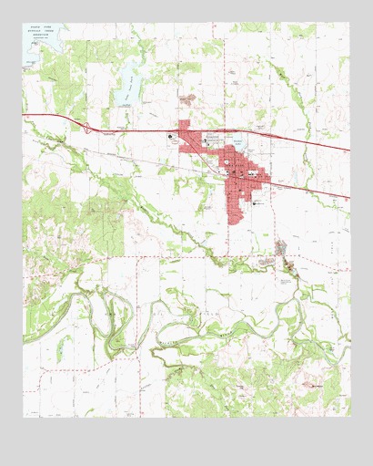
Iowa Park, TX USGS Topographic Map
Click on map above to begin viewing in our Map Viewer.

This topographic map contains these locations and features:
Feature Name Type Latitude Longitude GNIS ID View Map
Antelope CreekStreamN33.8976°W98.6962°1351145View Map
Antelope ParkParkN33.9565°W98.6576°2028898View Map
Bare ButteSummitN33.8851°W98.6403°1351505View Map
Boerne Public LibraryBuildingN33.9245°W98.7331°2015089View Map
Bradford Elementary SchoolSchoolN33.9462°W98.6634°2009485View Map
Bradford SchoolSchoolN33.9429°W98.6614°1352810View Map
Buffalo CreekStreamN33.9129°W98.6470°1353191View Map
Burnett ParkParkN33.8982°W98.7076°1353347View Map
Camp Chaparral Baptist Assembly ChurchChurchN33.8995°W98.6445°2024285View Map
Christ the King Catholic ChurchChurchN33.9590°W98.6756°2025040View Map
Church of Christ of Iowa ParkChurchN33.9523°W98.6656°2025049View Map
Church of GodChurchN33.9515°W98.6628°2025055View Map
City of Iowa ParkCivilN33.9623°W98.6819°2410112View Map
Cornerstone Pentecostal Church of GodChurchN33.9532°W98.6845°2024963View Map
Deep CreekStreamN33.9126°W98.7190°1355812View Map
East Fork Antelope CreekStreamN33.8915°W98.6889°1356609View Map
First Assembly of God Iowa Park ChurchChurchN33.9498°W98.6692°2024277View Map
First Baptist Church of Iowa ParkChurchN33.9520°W98.6692°2025071View Map
First Presbyterian Church of Iowa ParkChurchN33.9498°W98.6692°2024972View Map
First United Methodist Church of Iowa ParkChurchN33.9532°W98.6667°2025019View Map
Gordon LakeReservoirN33.9624°W98.6679°1358186View Map
Highland CemeteryCemeteryN33.9670°W98.6595°1359205View Map
Iowa ParkPopulated PlaceN33.9515°W98.6687°1360020View Map
Iowa Park Church of GodChurchN33.9515°W98.6617°2025059View Map
Iowa Park City HallBuildingN33.9514°W98.6675°2753721View Map
Iowa Park DivisionCivilN33.9812°W98.7195°1938857View Map
Iowa Park Police DepartmentBuildingN33.9511°W98.6672°2750409View Map
Iowa Park Post OfficePost OfficeN33.9512°W98.6662°2731902View Map
Iowa Park Volunteer Fire DepartmentBuildingN33.9511°W98.6669°2551933View Map
Kidwell Elementary SchoolSchoolN33.9612°W98.6803°2009456View Map
Kidwell SchoolSchoolN33.9632°W98.6806°1360631View Map
Lake Gordon DamDamN33.9618°W98.6670°1856246View Map
Lake Iowa ParkReservoirN33.9798°W98.7095°1360021View Map
Lake Iowa Park DamDamN33.9718°W98.7103°1856244View Map
Lutheran Church Good ShepherdChurchN33.9570°W98.6756°2025014View Map
N F LateralCanalN33.8845°W98.7398°1375090View Map
North Fork Buffalo CreekStreamN33.9618°W98.7348°1364046View Map
P M LateralCanalN33.9243°W98.6451°1364670View Map
Pacific Avenue Missionary Baptist ChurchChurchN33.9634°W98.6734°2025025View Map
South Fork Buffalo CreekStreamN33.9618°W98.7351°1368677View Map
Stevens CreekStreamN33.9448°W98.7070°1369181View Map
Temple HillSummitN33.8848°W98.6659°1369699View Map
United Pentecostal ChurchChurchN33.9570°W98.6756°2024969View Map
W F George Middle SchoolSchoolN33.9515°W98.6645°2009414View Map
Wichita CountyCivilN33.9880°W98.7036°1384028View Map
Wichita County Constable's Office Precinct 3BuildingN33.9843°W98.7248°2750786View Map

Note: Coordinates in the location and feature list above are referenced to NAD83 datum.


Copyright (C) 2008-2025 Ryan Niemi / Sunset Dynamics ... All Rights Reserved