TopoQuest Logo
Do you find TopoQuest useful?
Help keep TopoQuest running and adding new maps/features by donating!
Bitcoin:  19c7KJd3qBynnjoSw5npx9KScwjBe4ifkT
Litecoin:  LXs6TkuXGGXo1vDsWCkWVdjQX94eUKd6ui
Home View Maps Find Maps Find Places Resources & Links


Badger, South Dakota Topographic Map

USGS Map Title: Badger, SD
USGS Map MRC: 44097D2
DRG (GeoTIFF) Download: o44097d2.tif


Neighboring USGS Topographic Map Quads:


  Gertson Slough, SD  
44097E3
 

  Lake Norden, SD  
44097E2
 

  Lake Poinsett, SD  
44097E1
 

  Lake Preston NE, SD  
44097D3
 

  Badger, SD  
44097D2
 

  Arlington NE, SD  
44097D1
 

  Lake Preston East, SD  
44097C3
 

  Arlington, SD  
44097C2
 

  Lake Sinai, SD  
44097C1


Map MRC Location:

N45°
W98°
N45°
W97°
H8 H7 H6 H5 H4 H3 H2 H1
G8 G7 G6 G5 G4 G3 G2 G1
F8 F7 F6 F5 F4 F3 F2 F1
E8 E7 E6 E5 E4 E3 E2 E1
D8 D7 D6 D5 D4 D3 D2 D1
C8 C7 C6 C5 C4 C3 C2 C1
B8 B7 B6 B5 B4 B3 B2 B1
A8 A7 A6 A5 A4 A3 A2 A1
N44°
W98°
N44°
W97°

Badger, SD USGS 1:24K Topographic Map Preview:
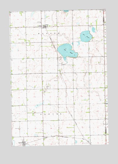
Badger, SD USGS Topographic Map
Click on map above to begin viewing in our Map Viewer.

This topographic map contains these locations and features:
Feature Name Type Latitude Longitude GNIS ID View Map
Andersen Farms AirportAirportN44.4683°W97.2230°2444003View Map
Arlington Municipal AirportAirportN44.3954°W97.1263°1260215View Map
BadgerPopulated PlaceN44.4852°W97.2048°1253738View Map
Badger CemeteryCemeteryN44.4848°W97.2140°1253739View Map
Badger Post OfficePost OfficeN44.4850°W97.2049°2709671View Map
Badger Volunteer Fire DepartmentBuildingN44.4854°W97.2047°2580670View Map
HetlandPopulated PlaceN44.3780°W97.2351°1265247View Map
Hetland CemeteryCemeteryN44.3915°W97.2404°1255527View Map
Lake BadgerLakeN44.4618°W97.1767°1253740View Map
Lake ThistedLakeN44.4752°W97.1520°1258527View Map
Lake Thisted CemeteryCemeteryN44.4842°W97.1473°1256034View Map
Lutheran Church (historical)ChurchN44.4861°W97.1476°1263819View Map
Nielsen CemeteryCemeteryN44.4347°W97.1894°1256701View Map
Pleasant Valley (historical)LocaleN44.4852°W97.1473°1263769View Map
School Number 13 (historical)SchoolN44.4869°W97.1476°1263802View Map
School Number 15 (historical)SchoolN44.4569°W97.2084°1263801View Map
School Number 18 (historical)SchoolN44.4850°W97.2303°1263800View Map
School Number 33 (historical)SchoolN44.3986°W97.1703°1263841View Map
School Number 44 (historical)SchoolN44.3975°W97.2090°1263842View Map
School Number 45 (historical)SchoolN44.4272°W97.2209°1263839View Map
Town of BadgerCivilN44.4855°W97.2079°1267275View Map
Town of HetlandCivilN44.3772°W97.2347°1267421View Map
Township of BadgerCivilN44.4949°W97.2225°1268539View Map
Township of DenverCivilN44.3859°W97.2039°1268543View Map
United CemeteryCemeteryN44.4995°W97.1292°1258708View Map

Note: Coordinates in the location and feature list above are referenced to NAD83 datum.


Copyright (C) 2008-2024 Ryan Niemi / Sunset Dynamics ... All Rights Reserved