TopoQuest Logo
Do you find TopoQuest useful?
Help keep TopoQuest running and adding new maps/features by donating!
Bitcoin:  19c7KJd3qBynnjoSw5npx9KScwjBe4ifkT
Litecoin:  LXs6TkuXGGXo1vDsWCkWVdjQX94eUKd6ui
Home View Maps Find Maps Find Places Resources & Links


Hollywood, Arkansas Topographic Map

USGS Map Title: Hollywood, AR
USGS Map MRC: 34093A2
DRG (GeoTIFF) Download: o34093a2.tif


Neighboring USGS Topographic Map Quads:


  Chalybeate Mountain East, AR  
34093B3
 

  De Gray, AR  
34093B2
 

  Caddo Valley, AR  
34093B1
 

  Okolona North, AR  
34093A3
 

  Hollywood, AR  
34093A2
 

  Arkadelphia, AR  
34093A1
 

  Okolona South, AR  
33093H3
 

  Gurdon, AR  
33093H2
 

  Curtis, AR  
33093H1


Map MRC Location:

N35°
W94°
N35°
W93°
H8 H7 H6 H5 H4 H3 H2 H1
G8 G7 G6 G5 G4 G3 G2 G1
F8 F7 F6 F5 F4 F3 F2 F1
E8 E7 E6 E5 E4 E3 E2 E1
D8 D7 D6 D5 D4 D3 D2 D1
C8 C7 C6 C5 C4 C3 C2 C1
B8 B7 B6 B5 B4 B3 B2 B1
A8 A7 A6 A5 A4 A3 A2 A1
N34°
W94°
N34°
W93°

Hollywood, AR USGS 1:24K Topographic Map Preview:
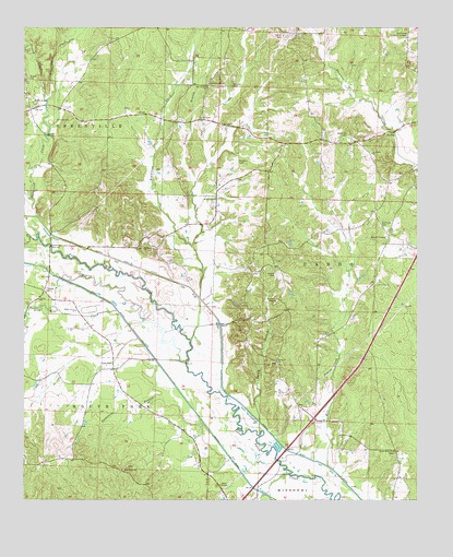
Hollywood, AR USGS Topographic Map
Click on map above to begin viewing in our Map Viewer.

This topographic map contains these locations and features:
Feature Name Type Latitude Longitude GNIS ID View Map
Arnold CemeteryCemeteryN34.0598°W93.1704°45930View Map
Blue Hole CreekStreamN34.0501°W93.2210°46751View Map
Bozeman CemeteryCemeteryN34.0968°W93.1471°46882View Map
Bradshaw CreekStreamN34.0532°W93.1946°46904View Map
Carter CemeteryCemeteryN34.1229°W93.1679°47492View Map
Clark CountyCivilN34.0510°W93.1764°66845View Map
Clayborn ChapelChurchN34.0526°W93.1702°47816View Map
Flat CreekStreamN34.0673°W93.1974°49102View Map
HollywoodPopulated PlaceN34.1040°W93.2468°77209View Map
Hollywood Baptist ChurchChurchN34.1065°W93.2493°64976View Map
Hollywood CreekStreamN34.0745°W93.2457°50255View Map
Hollywood Fire StationBuildingN34.1032°W93.2360°2116591View Map
Hollywood United Methodist ChurchChurchN34.1040°W93.2474°64975View Map
Lee CemeteryCemeteryN34.1009°W93.1943°51041View Map
Mill CreekStreamN34.0090°W93.1535°51989View Map
Mitchell CemeteryCemeteryN34.1098°W93.1841°52108View Map
Moores CreekStreamN34.0368°W93.1988°52176View Map
Mount Bethel Baptist ChurchChurchN34.0918°W93.1396°77702View Map
Mount Zion United Methodist ChurchChurchN34.0665°W93.2130°77755View Map
New Antioch ChurchChurchN34.1095°W93.1924°52616View Map
Patterson BranchStreamN34.0204°W93.1935°53219View Map
Piney Ridge ChurchChurchN34.0079°W93.2188°53492View Map
Rest Haven Memorial GardensCemeteryN34.1245°W93.1260°53989View Map
Richland CemeteryCemeteryN34.0729°W93.1371°54019View Map
Richmond Hill ChurchChurchN34.1101°W93.1918°54023View Map
Rodgers CemeteryCemeteryN34.0895°W93.1824°54155View Map
Sandy BranchStreamN34.0207°W93.1755°54573View Map
Shady Grove Baptist ChurchChurchN34.0501°W93.2338°78326View Map
Shady Grove ChurchChurchN34.0132°W93.1327°54705View Map
Shiloh Baptist ChurchChurchN34.0368°W93.1702°78347View Map
Sloan CemeteryCemeteryN34.0362°W93.2221°54910View Map
South Boat DitchCanalN34.0440°W93.2149°55011View Map
South CentralLocaleN34.0701°W93.1343°55015View Map
South Fork Terre Noire CreekStreamN34.0070°W93.1660°55030View Map
Stroud CemeteryCemeteryN34.1006°W93.2360°55278View Map
Stroud CreekStreamN34.1051°W93.2430°55279View Map
Township of CaddoCivilN34.0510°W93.1764°66430View Map
Township of Greenville (historical)CivilN34.1168°W93.2418°65018View Map
Trinity United Methodist ChurchChurchN34.0532°W93.2457°78579View Map
Victor TempleChurchN34.0040°W93.1877°55906View Map
Walnut BranchStreamN34.0829°W93.1968°55994View Map
Wilson CemeteryCemeteryN34.0793°W93.1896°56432View Map
Wingfield CreekStreamN34.0987°W93.2424°56460View Map

Note: Coordinates in the location and feature list above are referenced to NAD83 datum.


Copyright (C) 2008-2025 Ryan Niemi / Sunset Dynamics ... All Rights Reserved