TopoQuest Logo
Do you find TopoQuest useful?
Help keep TopoQuest running and adding new maps/features by donating!
Bitcoin:  19c7KJd3qBynnjoSw5npx9KScwjBe4ifkT
Litecoin:  LXs6TkuXGGXo1vDsWCkWVdjQX94eUKd6ui
Home View Maps Find Maps Find Places Resources & Links


Gurdon, Arkansas Topographic Map

USGS Map Title: Gurdon, AR
USGS Map MRC: 33093H2
DRG (GeoTIFF) Download: o33093h2.tif


Neighboring USGS Topographic Map Quads:


  Okolona North, AR  
34093A3
 

  Hollywood, AR  
34093A2
 

  Arkadelphia, AR  
34093A1
 

  Okolona South, AR  
33093H3
 

  Gurdon, AR  
33093H2
 

  Curtis, AR  
33093H1
 

  Prescott East, AR  
33093G3
 

  Whelen Springs, AR  
33093G2
 

  Reader, AR  
33093G1


Map MRC Location:

N34°
W94°
N34°
W93°
H8 H7 H6 H5 H4 H3 H2 H1
G8 G7 G6 G5 G4 G3 G2 G1
F8 F7 F6 F5 F4 F3 F2 F1
E8 E7 E6 E5 E4 E3 E2 E1
D8 D7 D6 D5 D4 D3 D2 D1
C8 C7 C6 C5 C4 C3 C2 C1
B8 B7 B6 B5 B4 B3 B2 B1
A8 A7 A6 A5 A4 A3 A2 A1
N33°
W94°
N33°
W93°

Gurdon, AR USGS 1:24K Topographic Map Preview:
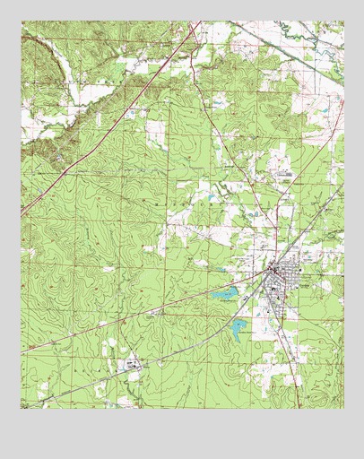
Gurdon, AR USGS Topographic Map
Click on map above to begin viewing in our Map Viewer.

This topographic map contains these locations and features:
Feature Name Type Latitude Longitude GNIS ID View Map
Beech Street Baptist ChurchChurchN33.9137°W93.1485°70012View Map
BeirnePopulated PlaceN33.8887°W93.2041°76289View Map
Beirne Baptist ChurchChurchN33.8909°W93.2043°65013View Map
Beirne Post OfficePost OfficeN33.8878°W93.2048°84288View Map
Beirne Rural Volunteer Fire DepartmentBuildingN33.8877°W93.2047°2116125View Map
Black BranchStreamN33.9476°W93.1766°46656View Map
Brown CemeteryCemeteryN33.9276°W93.1571°46991View Map
Cabe Middle SchoolSchoolN33.9081°W93.1911°2039317View Map
Caney CreekStreamN33.9912°W93.1266°47421View Map
Center Grove United Methodist ChurchChurchN33.9798°W93.2441°76566View Map
Center PointLocaleN33.9715°W93.1788°47639View Map
Center Point Baptist ChurchChurchN33.9712°W93.1804°65016View Map
City of GurdonCivilN33.9151°W93.1558°2403775View Map
Coffee CreekStreamN33.9290°W93.1513°47884View Map
Curtis Fire DepartmentBuildingN33.9983°W93.1296°2116334View Map
Eastern Star ChurchChurchN33.9398°W93.1327°48783View Map
First Baptist ChurchChurchN33.9204°W93.1491°70013View Map
First United Methodist ChurchChurchN33.9201°W93.1507°70014View Map
Greenville CemeteryCemeteryN33.9412°W93.1388°49667View Map
GurdonPopulated PlaceN33.9209°W93.1541°49742View Map
Gurdon Fire StationBuildingN33.9222°W93.1498°2116519View Map
Gurdon High SchoolSchoolN33.9093°W93.1883°65019View Map
Gurdon Lowe FieldAirportN33.9240°W93.1654°83712View Map
Gurdon Middle SchoolSchoolN33.9107°W93.1507°65020View Map
Gurdon Police DepartmentBuildingN33.9221°W93.1496°2118829View Map
Gurdon Pond OneReservoirN33.9123°W93.1708°80191View Map
Gurdon Pond One DamDamN33.9134°W93.1668°80190View Map
Gurdon Pond TwoReservoirN33.9051°W93.1652°80189View Map
Gurdon Pond Two DamDamN33.9051°W93.1652°80188View Map
Gurdon Primary SchoolSchoolN33.9198°W93.1423°65021View Map
Interchange 63CrossingN33.9973°W93.1841°58941View Map
Keyton (historical)Populated PlaceN33.9707°W93.2199°65023View Map
KGAP-FM (Gurdon)TowerN33.9451°W93.1788°85185View Map
Lick CreekStreamN33.9498°W93.1802°51137View Map
Mount Canaan Baptist ChurchChurchN33.9140°W93.1516°70015View Map
New Caney ChurchChurchN33.9395°W93.1568°52634View Map
New Home ChurchChurchN33.9784°W93.2366°52647View Map
New Ronok ChurchChurchN33.9426°W93.1466°52732View Map
North Boat DitchCanalN33.9937°W93.1338°52807View Map
Pruitt CreekStreamN33.9665°W93.2385°53832View Map
Rose Hedge CemeteryCemeteryN33.9243°W93.1413°54197View Map
Sandy BranchStreamN33.9432°W93.1674°54572View Map
Scrouge CreekStreamN33.9726°W93.2243°54654View Map
SmithtonPopulated PlaceN33.9418°W93.1268°56793View Map
Smithton (historical)Populated PlaceN33.9432°W93.1304°65028View Map
South Fork Baptist ChurchChurchN33.9926°W93.1952°78407View Map
Township of Missouri (historical)CivilN33.8918°W93.1335°66431View Map
Township of South Fork (historical)CivilN33.9987°W93.2496°65029View Map
White Oak CreekStreamN33.9001°W93.1252°56283View Map

Note: Coordinates in the location and feature list above are referenced to NAD83 datum.


Copyright (C) 2008-2024 Ryan Niemi / Sunset Dynamics ... All Rights Reserved