TopoQuest Logo
Do you find TopoQuest useful?
Help keep TopoQuest running and adding new maps/features by donating!
Bitcoin:  19c7KJd3qBynnjoSw5npx9KScwjBe4ifkT
Litecoin:  LXs6TkuXGGXo1vDsWCkWVdjQX94eUKd6ui
Home View Maps Find Maps Find Places Resources & Links


Homeland, Florida Topographic Map

USGS Map Title: Homeland, FL
USGS Map MRC: 27081G7
DRG (GeoTIFF) Download: o27081g7.tif


Neighboring USGS Topographic Map Quads:


  Mulberry, FL  
27081H8
 

  Bartow, FL  
27081H7
 

  Eloise, FL  
27081H6
 

  Bradley Junction, FL  
27081G8
 

  Homeland, FL  
27081G7
 

  Alturas, FL  
27081G6
 

  Baird, FL  
27081F8
 

  Bowling Green, FL  
27081F7
 

  Bereah, FL  
27081F6


Map MRC Location:

N28°
W82°
N28°
W81°
H8 H7 H6 H5 H4 H3 H2 H1
G8 G7 G6 G5 G4 G3 G2 G1
F8 F7 F6 F5 F4 F3 F2 F1
E8 E7 E6 E5 E4 E3 E2 E1
D8 D7 D6 D5 D4 D3 D2 D1
C8 C7 C6 C5 C4 C3 C2 C1
B8 B7 B6 B5 B4 B3 B2 B1
A8 A7 A6 A5 A4 A3 A2 A1
N27°
W82°
N27°
W81°

Homeland, FL USGS 1:24K Topographic Map Preview:
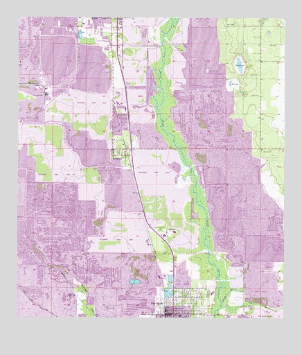
Homeland, FL USGS Topographic Map
Click on map above to begin viewing in our Map Viewer.

This topographic map contains these locations and features:
Feature Name Type Latitude Longitude GNIS ID View Map
Barber BranchStreamN27.8384°W81.8095°301434View Map
Bartow DivisionCivilN27.7916°W81.8586°1935690View Map
Bartow Public LibraryBuildingN27.8734°W81.8430°2447690View Map
Camp BranchStreamN27.8078°W81.7934°301431View Map
Carroll Railroad StationLocaleN27.8414°W81.8309°301429View Map
City of Fort MeadeCivilN27.7641°W81.8054°2403641View Map
Clear Springs MineMineN27.8656°W81.8137°301433View Map
Clear Springs Railroad StationLocaleN27.8622°W81.8145°301428View Map
Dalley Town Park Mobile Home ParkPopulated PlaceN27.7689°W81.8008°2448988View Map
Evergreen CemeteryCemeteryN27.7547°W81.7876°282302View Map
First Presbyterian ChurchChurchN27.7524°W81.7992°2481097View Map
Fort MeadePopulated PlaceN27.7523°W81.8017°282697View Map
Fort Meade City Public LibraryBuildingN27.7518°W81.8007°2448986View Map
Fort Meade Fire DepartmentBuildingN27.7628°W81.7846°2644647View Map
Fort Meade Middle Senior High SchoolSchoolN27.7596°W81.7828°299304View Map
Fort Meade Post OfficePost OfficeN27.7528°W81.8034°2448987View Map
Hancock CemeteryCemeteryN27.7545°W81.8287°283678View Map
Hendersons Mobile Home ParkPopulated PlaceN27.8699°W81.8299°2447696View Map
Historical Society of Fort MeadeBuildingN27.7507°W81.8054°2448985View Map
HomelandPopulated PlaceN27.8178°W81.8245°284212View Map
Homeland Census Designated PlaceCensusN27.8182°W81.8270°2583354View Map
Homeland Post OfficePost OfficeN27.8177°W81.8248°2768150View Map
John Singletary BridgeBridgeN27.7517°W81.7831°303579View Map
Mud LakeLakeN27.8481°W81.7738°287401View Map
Noralyn Mine LakeLakeN27.8414°W81.8609°308481View Map
Noralyn Railroad StationLocaleN27.8475°W81.8648°301430View Map
Oponys Town (historical)Populated PlaceN27.7836°W81.7998°294526View Map
Peace Creek CemeteryCemeteryN27.8536°W81.7862°288608View Map
Peace Valley MineMineN27.8003°W81.8056°301432View Map
PembrokePopulated PlaceN27.7864°W81.8051°295530View Map
Polk County Emergency Medical Services Station 2 Fort MeadeBuildingN27.7629°W81.7846°2661669View Map
Polk County Sheriff's Office Fort Meade SubstationBuildingN27.7532°W81.8023°2333546View Map
Riverside Elementary SchoolSchoolN27.7581°W81.7865°299303View Map
Rocky BranchStreamN27.7570°W81.7787°289875View Map
Sand LakeLakeN27.8558°W81.7710°290533View Map
Sink BranchStreamN27.7559°W81.7787°291169View Map
Tiger BayPopulated PlaceN27.7592°W81.8470°295673View Map
Varn Railroad Station (historical)LocaleN27.7617°W81.7629°301435View Map

Note: Coordinates in the location and feature list above are referenced to NAD83 datum.


Copyright (C) 2008-2024 Ryan Niemi / Sunset Dynamics ... All Rights Reserved