TopoQuest Logo
Do you find TopoQuest useful?
Help keep TopoQuest running and adding new maps/features by donating!
Bitcoin:  19c7KJd3qBynnjoSw5npx9KScwjBe4ifkT
Litecoin:  LXs6TkuXGGXo1vDsWCkWVdjQX94eUKd6ui
Home View Maps Find Maps Find Places Resources & Links


Alturas, Florida Topographic Map

USGS Map Title: Alturas, FL
USGS Map MRC: 27081G6
DRG (GeoTIFF) Download: o27081g6.tif


Neighboring USGS Topographic Map Quads:


  Bartow, FL  
27081H7
 

  Eloise, FL  
27081H6
 

  Lake Wales, FL  
27081H5
 

  Homeland, FL  
27081G7
 

  Alturas, FL  
27081G6
 

  Babson Park, FL  
27081G5
 

  Bowling Green, FL  
27081F7
 

  Bereah, FL  
27081F6
 

  Frostproof, FL  
27081F5


Map MRC Location:

N28°
W82°
N28°
W81°
H8 H7 H6 H5 H4 H3 H2 H1
G8 G7 G6 G5 G4 G3 G2 G1
F8 F7 F6 F5 F4 F3 F2 F1
E8 E7 E6 E5 E4 E3 E2 E1
D8 D7 D6 D5 D4 D3 D2 D1
C8 C7 C6 C5 C4 C3 C2 C1
B8 B7 B6 B5 B4 B3 B2 B1
A8 A7 A6 A5 A4 A3 A2 A1
N27°
W82°
N27°
W81°

Alturas, FL USGS 1:24K Topographic Map Preview:
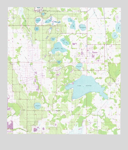
Alturas, FL USGS Topographic Map
Click on map above to begin viewing in our Map Viewer.

This topographic map contains these locations and features:
Feature Name Type Latitude Longitude GNIS ID View Map
AlturasPopulated PlaceN27.8717°W81.7151°277828View Map
Alturas Census Designated PlaceCensusN27.8417°W81.6952°2583323View Map
Alturas Elementary SchoolSchoolN27.8728°W81.7127°299287View Map
Alturas Post OfficePost OfficeN27.8722°W81.7149°2768190View Map
Crystal LakeLakeN27.8686°W81.7108°281118View Map
Gadau LakeLakeN27.8609°W81.6944°282867View Map
Gator LakeLakeN27.8415°W81.6865°282986View Map
Grassy LakeLakeN27.8214°W81.6932°283321View Map
Green Acres Mobile Home ParkPopulated PlaceN27.8345°W81.6416°2449593View Map
Jubilee Acres AirportAirportN27.7897°W81.6532°2770514View Map
Lake BuffumLakeN27.7970°W81.6632°279626View Map
Lake Buffum ChurchChurchN27.7736°W81.6951°279625View Map
Lake GordonLakeN27.8558°W81.6273°283224View Map
Lake HenryLakeN27.7783°W81.7164°283917View Map
Lake MillbiteLakeN27.8586°W81.7004°301426View Map
Lake PembrokeLakeN27.8559°W81.6672°288687View Map
Lake Wales Mobile Home ParkPopulated PlaceN27.8345°W81.6415°2449596View Map
Lake WalkerLakeN27.8540°W81.7175°292839View Map
Lizzie LakeLakeN27.8176°W81.6704°285894View Map
Long LakeLakeN27.8614°W81.7056°286015View Map
Perch LakeLakeN27.8626°W81.7164°295531View Map
Polecat LakeLakeN27.8441°W81.6995°289141View Map
Polk County Fire Department Station 2 AlturasBuildingN27.8712°W81.7154°2131413View Map
Round LakeLakeN27.8651°W81.7018°301427View Map
Southwest Lake GordonLakeN27.8478°W81.6314°2764898View Map
Surveyors LakeLakeN27.8350°W81.6936°291898View Map
Twin LakesLakeN27.8568°W81.6777°292608View Map
Villa Char Mar AirportAirportN27.7861°W81.6511°2717014View Map
WolfolkPopulated PlaceN27.8003°W81.6301°295715View Map

Note: Coordinates in the location and feature list above are referenced to NAD83 datum.


Copyright (C) 2008-2024 Ryan Niemi / Sunset Dynamics ... All Rights Reserved