TopoQuest Logo
Do you find TopoQuest useful?
Help keep TopoQuest running and adding new maps/features by donating!
Bitcoin:  19c7KJd3qBynnjoSw5npx9KScwjBe4ifkT
Litecoin:  LXs6TkuXGGXo1vDsWCkWVdjQX94eUKd6ui
Home View Maps Find Maps Find Places Resources & Links


Honeoye, New York Topographic Map

USGS Map Title: Honeoye, NY
USGS Map MRC: 42077G5
DRG (GeoTIFF) Download: o42077g5.tif


Neighboring USGS Topographic Map Quads:


  Rush, NY  
42077H6
 

  Honeoye Falls, NY  
42077H5
 

  Victor, NY  
42077H4
 

  Livonia, NY  
42077G6
 

  Honeoye, NY  
42077G5
 

  Bristol Center, NY  
42077G4
 

  Conesus, NY  
42077F6
 

  Springwater, NY  
42077F5
 

  Bristol Springs, NY  
42077F4


Map MRC Location:

N43°
W78°
N43°
W77°
H8 H7 H6 H5 H4 H3 H2 H1
G8 G7 G6 G5 G4 G3 G2 G1
F8 F7 F6 F5 F4 F3 F2 F1
E8 E7 E6 E5 E4 E3 E2 E1
D8 D7 D6 D5 D4 D3 D2 D1
C8 C7 C6 C5 C4 C3 C2 C1
B8 B7 B6 B5 B4 B3 B2 B1
A8 A7 A6 A5 A4 A3 A2 A1
N42°
W78°
N42°
W77°

Honeoye, NY USGS 1:24K Topographic Map Preview:
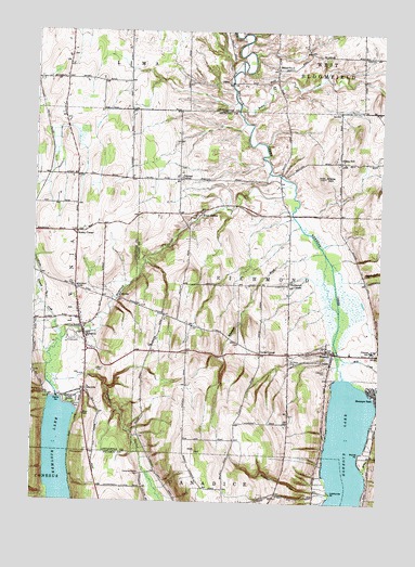
Honeoye, NY USGS Topographic Map
Click on map above to begin viewing in our Map Viewer.

This topographic map contains these locations and features:
Feature Name Type Latitude Longitude GNIS ID View Map
Abbey GulfValleyN42.8110°W77.5071°942116View Map
Affolter GullyValleyN42.7532°W77.5227°942197View Map
Allens HillPopulated PlaceN42.8409°W77.5150°942370View Map
Allens HillSummitN42.8367°W77.5205°942371View Map
Allens Hill CemeteryCemeteryN42.8413°W77.5175°2542288View Map
Allens Hill Free LibraryBuildingN42.8424°W77.5154°2617206View Map
Bebee CreekStreamN42.8556°W77.5514°943468View Map
Bosley CornerPopulated PlaceN42.8215°W77.6103°972249View Map
Bray GullyValleyN42.7591°W77.5051°944660View Map
Burns PointCapeN42.7634°W77.5067°945240View Map
California PointCapeN42.7528°W77.5169°945463View Map
Canadice Hollow CemeteryCemeteryN42.7573°W77.5855°945731View Map
Canadice OutletStreamN42.7806°W77.6181°945733View Map
Central SchoolSchoolN42.7906°W77.5028°946301View Map
Coye FieldAirportN42.7509°W77.5578°977941View Map
Curtis CornerPopulated PlaceN42.7895°W77.5428°972360View Map
Denison CornerPopulated PlaceN42.8359°W77.5728°948297View Map
Dennison Corners CemeteryCemeteryN42.8388°W77.5729°2542289View Map
Elderberry Mobile Home ParkPopulated PlaceN42.7876°W77.5302°2618219View Map
Frost HollowPopulated PlaceN42.8267°W77.5644°972520View Map
GlenvillePopulated PlaceN42.7801°W77.6058°972549View Map
HemlockPopulated PlaceN42.7942°W77.6064°952553View Map
Hemlock Baptist ChurchChurchN42.7919°W77.6058°2496928View Map
Hemlock CemeteryCemeteryN42.7963°W77.6033°2547853View Map
Hemlock Census Designated PlaceCensusN42.7938°W77.6074°2584265View Map
Hemlock Fire DepartmentBuildingN42.7965°W77.6090°2496926View Map
Hemlock High SchoolSchoolN42.7933°W77.6053°2496927View Map
Hemlock Lake ParkParkN42.7759°W77.6108°952564View Map
Hemlock OutletStreamN42.8353°W77.5325°952566View Map
Hemlock Post OfficePost OfficeN42.7962°W77.6072°2598815View Map
Hemlock United Methodist ChurchChurchN42.7958°W77.6078°2496925View Map
Hemlock Water Filtration PlantLocaleN42.7769°W77.6080°2598880View Map
HoneoyePopulated PlaceN42.7901°W77.5169°953132View Map
Honeoye Census Designated PlaceCensusN42.7901°W77.5148°2631231View Map
Honeoye LakeLakeN42.7543°W77.5116°970218View Map
Honeoye Lake County Wastewater Treatment PlantLocaleN42.7912°W77.5140°2617729View Map
Honeoye Mobile Home ParkPopulated PlaceN42.7541°W77.5205°2618237View Map
Honeoye ParkPopulated PlaceN42.7798°W77.5017°953136View Map
Honeoye Post OfficePost OfficeN42.7892°W77.5095°2617970View Map
Honeoye Public LibraryBuildingN42.7902°W77.5145°2617308View Map
IdahoPopulated PlaceN42.8617°W77.5556°972644View Map
Jacksonville (historical)Populated PlaceN42.8042°W77.6000°2547869View Map
Kinney CreekStreamN42.7928°W77.6144°954696View Map
Lakeview CemeteryCemeteryN42.7853°W77.5189°954981View Map
Lima Golf and Country ClubLocaleN42.8730°W77.6083°2598864View Map
Mill CreekStreamN42.7890°W77.5147°957231View Map
Old Fort Farm AirportAirportN42.8154°W77.5741°978060View Map
Purcell CemeteryCemeteryN42.7900°W77.5693°2542291View Map
Richmond CenterPopulated PlaceN42.8081°W77.5328°973003View Map
Richmond Center CemeteryCemeteryN42.8083°W77.5358°2542290View Map
Richmond Mills (historical)Populated PlaceN42.8264°W77.5728°2364509View Map
Richmond Volunteer Fire DepartmentBuildingN42.7894°W77.5172°2734912View Map
Saint Marys CemeteryCemeteryN42.7867°W77.5322°963897View Map
School Number 2 (historical)SchoolN42.8694°W77.6122°2108430View Map
School Number 3 (historical)SchoolN42.8367°W77.5733°2364510View Map
School Number 4 (historical)SchoolN42.8578°W77.5906°2108431View Map
School Number 4 (historical)SchoolN42.7533°W77.5558°2364529View Map
School Number 4 (historical)SchoolN42.8219°W77.5697°2364549View Map
School Number 5 (historical)SchoolN42.8653°W77.5381°975426View Map
School Number 5 (historical)SchoolN42.8294°W77.5358°2364550View Map
School Number 7 (historical)SchoolN42.8086°W77.5333°2364569View Map
Short CemeteryCemeteryN42.7848°W77.6017°965168View Map
Town of RichmondCivilN42.7912°W77.5246°978648View Map
Whetstone BrookStreamN42.8173°W77.5208°971028View Map
Wynn FarmsLocaleN42.8386°W77.6069°2548132View Map

Note: Coordinates in the location and feature list above are referenced to NAD83 datum.


Copyright (C) 2008-2025 Ryan Niemi / Sunset Dynamics ... All Rights Reserved