TopoQuest Logo
Do you find TopoQuest useful?
Help keep TopoQuest running and adding new maps/features by donating!
Bitcoin:  19c7KJd3qBynnjoSw5npx9KScwjBe4ifkT
Litecoin:  LXs6TkuXGGXo1vDsWCkWVdjQX94eUKd6ui
Home View Maps Find Maps Find Places Resources & Links


Honesdale, Pennsylvania Topographic Map

USGS Map Title: Honesdale, PA
USGS Map MRC: 41075E3
DRG (GeoTIFF) Download: o41075e3.tif


Neighboring USGS Topographic Map Quads:


  Forest City, PA  
41075F4
 

  Aldenville, PA  
41075F3
 

  Galilee, PA  
41075F2
 

  Waymart, PA  
41075E4
 

  Honesdale, PA  
41075E3
 

  White Mills, PA  
41075E2
 

  Lake Ariel, PA  
41075D4
 

  Lakeville, PA  
41075D3
 

  Hawley, PA  
41075D2


Map MRC Location:

N42°
W76°
N42°
W75°
H8 H7 H6 H5 H4 H3 H2 H1
G8 G7 G6 G5 G4 G3 G2 G1
F8 F7 F6 F5 F4 F3 F2 F1
E8 E7 E6 E5 E4 E3 E2 E1
D8 D7 D6 D5 D4 D3 D2 D1
C8 C7 C6 C5 C4 C3 C2 C1
B8 B7 B6 B5 B4 B3 B2 B1
A8 A7 A6 A5 A4 A3 A2 A1
N41°
W76°
N41°
W75°

Honesdale, PA USGS 1:24K Topographic Map Preview:
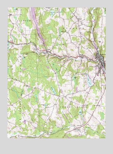
Honesdale, PA USGS Topographic Map
Click on map above to begin viewing in our Map Viewer.

This topographic map contains these locations and features:
Feature Name Type Latitude Longitude GNIS ID View Map
Bear SwampSwampN41.5675°W75.3138°1168948View Map
Beech GrovePopulated PlaceN41.6018°W75.3010°1203050View Map
BethanyPopulated PlaceN41.6131°W75.2843°1169335View Map
Borough of BethanyCivilN41.6143°W75.2872°1215684View Map
Borough of HonesdaleCivilN41.5773°W75.2524°1215686View Map
Borough of PromptonCivilN41.5891°W75.3275°1215687View Map
Burns PondLakeN41.6217°W75.3663°1170736View Map
Cadjaw DamDamN41.5618°W75.2746°1195659View Map
Cadjaw PondReservoirN41.5545°W75.2707°1170864View Map
Cadjaw Pond DamDamN41.5618°W75.2735°1208815View Map
Cavage Personal Use Airport (historical)AirportN41.5939°W75.3551°1194258View Map
Cherry RidgePopulated PlaceN41.5318°W75.2785°1171651View Map
Cherry Ridge AirportAirportN41.5157°W75.2536°1194247View Map
ClemoPopulated PlaceN41.5040°W75.3241°1171986View Map
Coggins CornerPopulated PlaceN41.6170°W75.3724°1203303View Map
Collins BrookStreamN41.5129°W75.2943°1172216View Map
Collins Pond DamDamN41.5184°W75.2980°1195632View Map
Crockenburg PondLakeN41.5317°W75.3262°1172706View Map
Darling CemeteryCemeteryN41.5387°W75.2931°1185023View Map
Dyberry CemeteryCemeteryN41.5840°W75.2581°1173674View Map
Dyberry CreekStreamN41.5781°W75.2541°1173676View Map
East Cherry Ridge SchoolSchoolN41.5306°W75.2568°1214731View Map
Elk Forest Resort Golf CourseLocaleN41.5873°W75.3635°1205613View Map
FermoyPopulated PlaceN41.5534°W75.3543°1197761View Map
Fermoy SchoolSchoolN41.5551°W75.3632°1174693View Map
ForteniaPopulated PlaceN41.5776°W75.2935°1175023View Map
General Edgar Jadwin DamDamN41.6119°W75.2649°1175512View Map
Glass Factory CemeteryCemeteryN41.6234°W75.3105°1175676View Map
Glass Pond Dam Number OneDamN41.6206°W75.3145°1195706View Map
Glass Pond Number OneReservoirN41.6197°W75.3179°1175677View Map
Glass Pond Number Two DamDamN41.6246°W75.3203°1195709View Map
Golf HillSummitN41.5848°W75.2713°1175789View Map
Gredlein PondLakeN41.5579°W75.2900°1176049View Map
Headley BrookStreamN41.5818°W75.3382°1176723View Map
Hoadley SchoolSchoolN41.5123°W75.2802°1177144View Map
HoadleysPopulated PlaceN41.5093°W75.2855°1177145View Map
HonesdalePopulated PlaceN41.5768°W75.2588°1192628View Map
Honesdale Emergency Medical ServicesBuildingN41.5411°W75.2531°2722137View Map
Honesdale Fire Department Hose Company 1BuildingN41.5699°W75.2540°2653547View Map
Honesdale Fire Department Protection Engine Company 3BuildingN41.5774°W75.2579°2652657View Map
Honesdale High SchoolSchoolN41.5606°W75.2593°1207424View Map
Honesdale Police DepartmentBuildingN41.5744°W75.2570°2780457View Map
Honesdale Post OfficePost OfficeN41.5727°W75.2562°2780036View Map
KeenPopulated PlaceN41.5929°W75.3738°1212923View Map
Keen CemeteryCemeteryN41.5928°W75.3686°1178287View Map
Keen Lake DamDamN41.5918°W75.3730°1195688View Map
Lake WanokaReservoirN41.5237°W75.2810°1190579View Map
Lincoln Elementary SchoolSchoolN41.5670°W75.2513°1207422View Map
Mican DamDamN41.5787°W75.3555°1208783View Map
Mican PondReservoirN41.5767°W75.3549°1180995View Map
Mile BrookStreamN41.5056°W75.3357°1181097View Map
Pennsylvania State Police Troop R Honesdale StationBuildingN41.5107°W75.2794°2777359View Map
Pond BrookStreamN41.5087°W75.3088°1184229View Map
PromptonPopulated PlaceN41.5829°W75.3252°1184438View Map
Prompton DamDamN41.5918°W75.3280°1195687View Map
Prompton Fire and Rescue Unit Station 94BuildingN41.5821°W75.3242°2653112View Map
Prompton LakeReservoirN41.6099°W75.3380°1193161View Map
Prompton Post OfficePost OfficeN41.5855°W75.3257°2768358View Map
Prompton State ParkParkN41.6084°W75.3330°1212924View Map
Reining DamDamN41.5418°W75.3146°1195651View Map
Reining PondReservoirN41.5431°W75.3145°1184884View Map
Richard DamDamN41.5437°W75.2813°1208782View Map
Saint Johns CemeteryCemeteryN41.5626°W75.2510°1186080View Map
Saint Mary Magdalen CemeteryCemeteryN41.5874°W75.2607°1186402View Map
Saint Patricks ChurchChurchN41.5498°W75.3493°1186538View Map
Schoonover CemeteryCemeteryN41.5927°W75.2646°1187121View Map
SeelyvillePopulated PlaceN41.5776°W75.2810°1187223View Map
Seelyville Fire Company Station 12BuildingN41.5771°W75.2805°2653104View Map
SteenePopulated PlaceN41.5901°W75.3505°1204727View Map
Stourbridge Elementary SchoolSchoolN41.5743°W75.2610°1207421View Map
Texas Number 4 Fire CompanyBuildingN41.5616°W75.2575°2653009View Map
Texas Rod Gun Club DamDamN41.5184°W75.2996°1195634View Map
Texas Rod Gun Club LakeReservoirN41.5213°W75.3009°1195633View Map
Township of Cherry RidgeCivilN41.5235°W75.2904°1217215View Map
Van Auken CreekStreamN41.5818°W75.3246°1190330View Map
Watts HillSummitN41.5923°W75.2566°1190703View Map
Wayne County Sheriff's OfficeBuildingN41.5749°W75.2534°2780541View Map
Wayne Highlands Middle SchoolSchoolN41.5595°W75.2580°1207423View Map
Wayne Memorial HospitalHospitalN41.5766°W75.2603°2718084View Map
WDNH-AM (Honesdale)TowerN41.5537°W75.2546°1200508View Map
West Branch Lackawaxen RiverStreamN41.5776°W75.2537°1190911View Map
Wilder SwampSwampN41.5441°W75.3557°1191425View Map
Woolen Mill DamDamN41.5765°W75.2802°1208803View Map

Note: Coordinates in the location and feature list above are referenced to NAD83 datum.


Copyright (C) 2008-2025 Ryan Niemi / Sunset Dynamics ... All Rights Reserved