TopoQuest Logo
Do you find TopoQuest useful?
Help keep TopoQuest running and adding new maps/features by donating!
Bitcoin:  19c7KJd3qBynnjoSw5npx9KScwjBe4ifkT
Litecoin:  LXs6TkuXGGXo1vDsWCkWVdjQX94eUKd6ui
Home View Maps Find Maps Find Places Resources & Links


Waymart, Pennsylvania Topographic Map

USGS Map Title: Waymart, PA
USGS Map MRC: 41075E4
DRG (GeoTIFF) Download: o41075e4.tif


Neighboring USGS Topographic Map Quads:


  Clifford, PA  
41075F5
 

  Forest City, PA  
41075F4
 

  Aldenville, PA  
41075F3
 

  Carbondale, PA  
41075E5
 

  Waymart, PA  
41075E4
 

  Honesdale, PA  
41075E3
 

  Olyphant, PA  
41075D5
 

  Lake Ariel, PA  
41075D4
 

  Lakeville, PA  
41075D3


Map MRC Location:

N42°
W76°
N42°
W75°
H8 H7 H6 H5 H4 H3 H2 H1
G8 G7 G6 G5 G4 G3 G2 G1
F8 F7 F6 F5 F4 F3 F2 F1
E8 E7 E6 E5 E4 E3 E2 E1
D8 D7 D6 D5 D4 D3 D2 D1
C8 C7 C6 C5 C4 C3 C2 C1
B8 B7 B6 B5 B4 B3 B2 B1
A8 A7 A6 A5 A4 A3 A2 A1
N41°
W76°
N41°
W75°

Waymart, PA USGS 1:24K Topographic Map Preview:
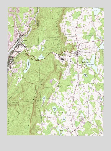
Waymart, PA USGS Topographic Map
Click on map above to begin viewing in our Map Viewer.

This topographic map contains these locations and features:
Feature Name Type Latitude Longitude GNIS ID View Map
Belmont BreakerBuildingN41.5862°W75.4874°1202351View Map
Belmont DamDamN41.5908°W75.4807°1195685View Map
Belmont ReservoirReservoirN41.5912°W75.4798°1202629View Map
Borough of WaymartCivilN41.5866°W75.4047°1215689View Map
Bronson PondReservoirN41.5260°W75.4381°1170316View Map
Bronson Pond DamDamN41.5228°W75.4382°1195641View Map
Brownell DamDamN41.5751°W75.4746°1195670View Map
Brownell ReservoirReservoirN41.5675°W75.4737°1170381View Map
Brunsons Pond DamDamN41.5228°W75.4380°1208809View Map
Camp LadoreLocaleN41.5726°W75.3985°1888466View Map
Camp-With-A-WindLocaleN41.5715°W75.4021°1171121View Map
Canaan SchoolSchoolN41.5704°W75.4099°1198534View Map
Carbondale Number Four DamDamN41.5751°W75.4580°1195669View Map
Carbondale Number Four ReservoirReservoirN41.5763°W75.4560°1195668View Map
Coal BrookStreamN41.5851°W75.4977°1172047View Map
Curtis PondReservoirN41.5356°W75.3778°1172856View Map
Deerfield PondReservoirN41.5890°W75.4531°1888468View Map
East Canaan CemeteryCemeteryN41.5178°W75.4014°1173786View Map
Elk Creek BreakerBuildingN41.5995°W75.4846°1202354View Map
Elk LakeReservoirN41.6228°W75.3852°1174114View Map
Flying Fox Airport (historical)AirportN41.5376°W75.4099°1194253View Map
Grattan Singer Hose Company Station 61BuildingN41.5947°W75.4813°2653415View Map
Hetzel PondReservoirN41.5198°W75.4009°1176927View Map
Hetzell Pond DamDamN41.5182°W75.3990°1208794View Map
High KnobSummitN41.5931°W75.4310°1177007View Map
Hoadley PondReservoirN41.5591°W75.3984°1177143View Map
Honey Mud PondReservoirN41.6135°W75.3792°1177346View Map
Jones and Voyles Mine (historical)MineN41.5684°W75.4946°1207255View Map
Keen LakeReservoirN41.5871°W75.3769°1178288View Map
Kellachows AirportAirportN41.5220°W75.3961°1888465View Map
Lake LadoreReservoirN41.5705°W75.3902°1195673View Map
Lake Ladore DamDamN41.5787°W75.3862°1195674View Map
Lake QuinnLakeN41.5045°W75.4312°1199941View Map
Lake Quinn DamDamN41.5081°W75.4260°1195629View Map
Little Keen PondReservoirN41.5958°W75.3793°1179574View Map
Little Keen Pond DamDamN41.5951°W75.3763°1195691View Map
Machell Mill DamDamN41.5070°W75.4224°1208802View Map
Marian Community Hospital (historical)HospitalN41.5716°W75.4962°2718030View Map
Moosic MountainsRangeN41.5631°W75.4452°1199913View Map
Morss Tannery (historical)BuildingN41.5931°W75.4846°1207254View Map
Number Four ReservoirReservoirN41.5745°W75.4593°1184937View Map
Old Canaan CemeteryCemeteryN41.5677°W75.4053°1182901View Map
Panther Bluff PondReservoirN41.5928°W75.4509°1183242View Map
Pennsylvania State Police TowerTowerN41.5367°W75.4663°1208374View Map
Racket Brook BreakerBuildingN41.5812°W75.4746°1202355View Map
Reservoir Number SevenReservoirN41.5846°W75.4539°1195678View Map
Reservoir Number Seven DamDamN41.5818°W75.4546°1195679View Map
Robinson PondReservoirN41.5345°W75.4524°1185229View Map
Russian MonasteryChurchN41.5154°W75.4024°1185661View Map
Saint Tikhons DamDamN41.5126°W75.3982°1208774View Map
Saint Tikhons SeminarySchoolN41.5148°W75.4010°1888464View Map
Salem FiretowerTowerN41.5504°W75.4566°1205103View Map
Salem HillSummitN41.5504°W75.4568°1186857View Map
SimpsonPopulated PlaceN41.5917°W75.4852°1187702View Map
Simpson Census Designated PlaceCensusN41.5946°W75.4814°2630039View Map
Simpson Colliery BreakerBuildingN41.6015°W75.4746°1202353View Map
South CanaanPopulated PlaceN41.5054°W75.4121°1199566View Map
South Canaan CemeteryCemeteryN41.5109°W75.4163°1188046View Map
South Canaan Post OfficePost OfficeN41.5048°W75.4122°2780038View Map
State Correctional Institution WaymartBuildingN41.5743°W75.4286°1174551View Map
State Correctional Institution Waymart Fire DepartmentBuildingN41.5756°W75.4319°2653582View Map
State Game Lands Number 300ParkN41.5084°W75.4413°1208375View Map
Telshaw PondReservoirN41.5163°W75.4258°1189344View Map
Township of CanaanCivilN41.5698°W75.3942°1217214View Map
Township of South CanaanCivilN41.5144°W75.3960°1217229View Map
United States Penitentiary CanaanBuildingN41.5636°W75.4193°2757208View Map
WaymartPopulated PlaceN41.5804°W75.4082°1190710View Map
Waymart Post OfficePost OfficeN41.5832°W75.4073°2724966View Map
Waymart Volunteer Ambulance ServiceBuildingN41.5786°W75.4078°2722142View Map
Waymart Volunteer Fire Company Station 75BuildingN41.5827°W75.4089°2653113View Map
WCDL-AM (Carbondale)TowerN41.5579°W75.4860°1200509View Map
Whites CrossingPopulated PlaceN41.5862°W75.4774°1212037View Map
Whites Crossing Fire Company Station 62BuildingN41.5866°W75.4763°2653072View Map
Wilson CreekStreamN41.5931°W75.4846°1191536View Map
WLSP-FM (Carbondale)TowerN41.5437°W75.4618°1200314View Map

Note: Coordinates in the location and feature list above are referenced to NAD83 datum.


Copyright (C) 2008-2024 Ryan Niemi / Sunset Dynamics ... All Rights Reserved