TopoQuest Logo
Do you find TopoQuest useful?
Help keep TopoQuest running and adding new maps/features by donating!
Bitcoin:  19c7KJd3qBynnjoSw5npx9KScwjBe4ifkT
Litecoin:  LXs6TkuXGGXo1vDsWCkWVdjQX94eUKd6ui
Home View Maps Find Maps Find Places Resources & Links


Hooker, Georgia Topographic Map

USGS Map Title: Hooker, GA
USGS Map MRC: 34085H4
DRG (GeoTIFF) Download: o34085h4.tif


Neighboring USGS Topographic Map Quads:


  Sequatchie, TN  
35085A5
 

  Wauhatchie, TN  
35085A4
 

  Chattanooga, TN  
35085A3
 

  New Home, GA  
34085H5
 

  Hooker, GA  
34085H4
 

  Fort Oglethorpe, GA  
34085H3
 

  Trenton, GA  
34085G5
 

  Durham, GA  
34085G4
 

  Kensington, GA  
34085G3


Map MRC Location:

N35°
W86°
N35°
W85°
H8 H7 H6 H5 H4 H3 H2 H1
G8 G7 G6 G5 G4 G3 G2 G1
F8 F7 F6 F5 F4 F3 F2 F1
E8 E7 E6 E5 E4 E3 E2 E1
D8 D7 D6 D5 D4 D3 D2 D1
C8 C7 C6 C5 C4 C3 C2 C1
B8 B7 B6 B5 B4 B3 B2 B1
A8 A7 A6 A5 A4 A3 A2 A1
N34°
W86°
N34°
W85°

Hooker, GA USGS 1:24K Topographic Map Preview:
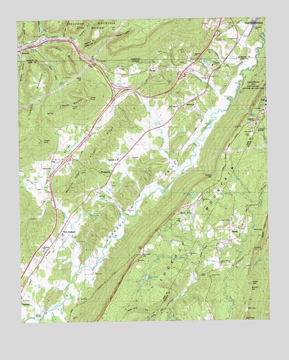
Hooker, GA USGS Topographic Map
Click on map above to begin viewing in our Map Viewer.

This topographic map contains these locations and features:
Feature Name Type Latitude Longitude GNIS ID View Map
Aetna HollowValleyN34.9929°W85.4863°1309988View Map
Aetna SpringSpringN34.9959°W85.4870°1309990View Map
Bates CemeteryCemeteryN34.8951°W85.4625°310855View Map
Bethlehem CemeteryCemeteryN34.9392°W85.4850°334373View Map
Bethlehem ChurchChurchN34.9392°W85.4841°311250View Map
Brock CemeteryCemeteryN34.8853°W85.4700°311819View Map
Brown LakeReservoirN34.9195°W85.4651°334377View Map
Burkhalter GapGapN34.9026°W85.4386°354912View Map
Calvary ChurchChurchN34.9773°W85.4338°351989View Map
Camp LookoutLocaleN34.8945°W85.4063°312237View Map
Clouse HollowValleyN34.9907°W85.4957°1280767View Map
Cole SpringSpringN34.9307°W85.4870°312819View Map
Covenant CollegeSchoolN34.9639°W85.3755°313047View Map
Deakins CemeteryCemeteryN34.9762°W85.4038°355469View Map
Dry Wash BranchStreamN34.9292°W85.4833°313688View Map
Dugan PointCapeN34.9498°W85.4886°313714View Map
Egypt HollowValleyN34.9887°W85.4923°313874View Map
Flintstone Air Force Station (historical)MilitaryN34.9531°W85.3822°2087614View Map
Friendship Baptist ChurchChurchN34.9056°W85.4880°355960View Map
Fuggett BranchStreamN34.8781°W85.4236°314444View Map
Geber BranchStreamN34.9240°W85.3788°355989View Map
Griffin ChurchChurchN34.9167°W85.4186°314904View Map
Hall GapGapN34.9617°W85.4861°315041View Map
Harbin SpringSpringN34.9880°W85.4926°1286794View Map
Haswell CemeteryCemeteryN34.9801°W85.4461°315225View Map
Hawk CliffCliffN34.8906°W85.3836°315239View Map
High PointCliffN34.8756°W85.3869°315390View Map
HinklesPopulated PlaceN34.9084°W85.3944°331993View Map
Hinkles ChurchChurchN34.9165°W85.3863°354082View Map
HookerPopulated PlaceN34.9790°W85.4338°332019View Map
Hoosier GulfValleyN34.9915°W85.4714°1288259View Map
Jack BranchStreamN34.8781°W85.4844°315978View Map
Jackson CemeteryCemeteryN34.9637°W85.3775°316004View Map
Jackson SpringSpringN34.9597°W85.3827°316022View Map
JamesburgPopulated PlaceN34.8920°W85.4119°354087View Map
Jones SpringSpringN34.9816°W85.4839°316257View Map
Keef SpringSpringN34.9928°W85.4845°1289941View Map
Kennedy CemeteryCemeteryN34.9765°W85.4772°316382View Map
Lake EdnaReservoirN34.9822°W85.4066°1283539View Map
Lawson MountainSummitN34.9670°W85.4900°356349View Map
Long SpringSpringN34.9880°W85.4953°1292009View Map
Lookout Mountain AirportAirportN34.9036°W85.4599°2442637View Map
Lookout Mountain ChurchChurchN34.8990°W85.3988°317400View Map
Lookout Mountain DivisionCivilN34.8776°W85.4061°1936262View Map
Lookout Mountain Junior High SchoolSchoolN34.9565°W85.3800°334386View Map
Magill CemeteryCemeteryN34.9974°W85.3917°1292499View Map
McCallie GapGapN34.8881°W85.3836°317849View Map
McClain BranchStreamN34.8912°W85.4755°317858View Map
McCollum BranchStreamN34.9206°W85.4489°317871View Map
McCollum RidgeRidgeN34.9326°W85.4725°334387View Map
Mill CreekStreamN34.9915°W85.4866°1269803View Map
Miller GapGapN34.8798°W85.3861°318261View Map
MorganvillePopulated PlaceN34.9365°W85.4536°332417View Map
Morganville United Methodist ChurchChurchN34.9354°W85.4547°347470View Map
Morrison BranchStreamN34.8829°W85.4789°318496View Map
Mount Olive CemeteryCemeteryN34.9023°W85.4152°354133View Map
Mount Olive ChurchChurchN34.9029°W85.4147°318778View Map
Mount Zion ChurchChurchN34.9765°W85.4330°334389View Map
Murphy HollowValleyN34.9870°W85.4989°319162View Map
Murphy Hollow CreekStreamN34.9879°W85.4994°356415View Map
New EnglandPopulated PlaceN34.9104°W85.4802°342351View Map
New England Baptist ChurchChurchN34.9092°W85.4791°334391View Map
Nickajack GapGapN34.9045°W85.3825°319597View Map
North Dade ChurchChurchN34.9631°W85.4197°319640View Map
North Dade SchoolSchoolN34.9420°W85.4502°319641View Map
North Dade Volunteer Fire DepartmentBuildingN34.9631°W85.4203°2603865View Map
Open Door ChurchChurchN34.9270°W85.4566°356518View Map
Paris HollowValleyN34.9763°W85.4568°320201View Map
Payne ChapelChurchN34.9162°W85.3938°320296View Map
Payne GapGapN34.9123°W85.3775°320299View Map
Payne School (historical)SchoolN34.9026°W85.3997°354159View Map
Paynes Chapel CemeteryCemeteryN34.9156°W85.3941°354160View Map
Pope CreekStreamN34.9367°W85.4177°321013View Map
Pope SpringSpringN34.9782°W85.4151°321019View Map
Price CemeteryCemeteryN34.9903°W85.4983°1298495View Map
Pulltight HollowValleyN34.9836°W85.4601°1298666View Map
Pump GulfValleyN34.8821°W85.4253°321224View Map
Ray CemeteryCemeteryN34.9737°W85.4775°321332View Map
Saint Pauls Church (historical)ChurchN34.9756°W85.4336°334398View Map
Scenic Land ChurchChurchN34.9009°W85.4408°322623View Map
Sims SpringSpringN34.9197°W85.4629°323026View Map
Sims Spring BranchStreamN34.9109°W85.4730°323027View Map
Sitton Gulch CreekStreamN34.8765°W85.4902°356537View Map
Skyuka SpringSpringN34.9695°W85.3884°323062View Map
Skyuka TrailTrailN34.9795°W85.3802°323063View Map
Slygo Missionary Baptist ChurchChurchN34.9426°W85.4816°323089View Map
Slygo RidgeRidgeN34.9487°W85.4577°323090View Map
Slygo ValleyValleyN34.9293°W85.4840°356539View Map
Smythe LakeReservoirN34.8984°W85.5000°339706View Map
Smythe Lake DamDamN34.8984°W85.5000°339705View Map
Squirrel Town CreekStreamN34.8976°W85.4694°323492View Map
State Line ChurchChurchN34.9915°W85.3888°1271274View Map
Stidmon GapGapN34.9345°W85.4022°323610View Map
Street PointCliffN34.9676°W85.4644°323671View Map
Sugar Camp GulfValleyN34.8781°W85.4343°323716View Map
Summit CemeteryCemeteryN34.9823°W85.4605°323745View Map
Tarkiln GapGapN34.9637°W85.4727°323922View Map
Tatum MountainSummitN34.9665°W85.4658°333194View Map
Taylor SpringSpringN34.9068°W85.4772°323954View Map
Tucker BranchStreamN34.8981°W85.4105°324344View Map
Tucker Branch LakeReservoirN34.8917°W85.4380°324346View Map
Tucker Branch Lake DamDamN34.8942°W85.4363°339699View Map
Walker County Emergency Services Fire Station 4BuildingN34.9120°W85.3926°2604783View Map
Water Tank HollowValleyN34.9930°W85.4773°1304404View Map
Waterfall BranchStreamN34.8801°W85.4847°356621View Map
Wauhatchie BranchStreamN34.9676°W85.3938°324927View Map
Wauhatchie YardsLocaleN34.9987°W85.3777°1273949View Map
WBDX-FM (Trenton)TowerN34.8990°W85.4439°352803View Map
WELF-TV (Dalton)TowerN34.9520°W85.3827°352854View Map
West BrowPopulated PlaceN34.9229°W85.4152°333390View Map
West Brow ChapelChurchN34.9156°W85.4258°356626View Map
West Brow ChurchChurchN34.9254°W85.4080°334404View Map
West Brow Fire DepartmentBuildingN34.9218°W85.4188°2604662View Map
West Brow LakeReservoirN34.9272°W85.4125°325040View Map
West Brow Lake DamDamN34.9284°W85.4113°339701View Map
West Brow School (historical)SchoolN34.9190°W85.4180°334405View Map
WhitesidePopulated PlaceN34.9873°W85.4977°1314101View Map
Whiteside Baptist ChurchChurchN34.9881°W85.4911°1643761View Map
Whiteside Church of GodChurchN34.9906°W85.4897°1314248View Map
Whiteside Post OfficePost OfficeN34.9896°W85.4977°1650228View Map
Whiteside United Methodist ChurchChurchN34.9854°W85.4980°1314249View Map
WildwoodPopulated PlaceN34.9634°W85.4111°333427View Map
Wildwood ChurchChurchN34.9631°W85.4105°352019View Map
Wildwood ChurchChurchN34.9759°W85.4050°356640View Map
Wildwood Lifestyle Center and HospitalHospitalN34.9807°W85.4018°325296View Map
Wildwood Post OfficePost OfficeN34.9631°W85.4193°352020View Map
Windy GapGapN34.9759°W85.4680°325450View Map
Windy MountainSummitN34.9792°W85.4733°333448View Map
Windy MountainSummitN34.9856°W85.4755°1274867View Map

Note: Coordinates in the location and feature list above are referenced to NAD83 datum.


Copyright (C) 2008-2024 Ryan Niemi / Sunset Dynamics ... All Rights Reserved