TopoQuest Logo
Do you find TopoQuest useful?
Help keep TopoQuest running and adding new maps/features by donating!
Bitcoin:  19c7KJd3qBynnjoSw5npx9KScwjBe4ifkT
Litecoin:  LXs6TkuXGGXo1vDsWCkWVdjQX94eUKd6ui
Home View Maps Find Maps Find Places Resources & Links


Kensington, Georgia Topographic Map

USGS Map Title: Kensington, GA
USGS Map MRC: 34085G3
DRG (GeoTIFF) Download: o34085g3.tif


Neighboring USGS Topographic Map Quads:


  Hooker, GA  
34085H4
 

  Fort Oglethorpe, GA  
34085H3
 

  East Ridge, TN  
34085H2
 

  Durham, GA  
34085G4
 

  Kensington, GA  
34085G3
 

  Nickajack Gap, GA  
34085G2
 

  Cedar Grove, GA  
34085F4
 

  LaFayette, GA  
34085F3
 

  Catlett, GA  
34085F2


Map MRC Location:

N35°
W86°
N35°
W85°
H8 H7 H6 H5 H4 H3 H2 H1
G8 G7 G6 G5 G4 G3 G2 G1
F8 F7 F6 F5 F4 F3 F2 F1
E8 E7 E6 E5 E4 E3 E2 E1
D8 D7 D6 D5 D4 D3 D2 D1
C8 C7 C6 C5 C4 C3 C2 C1
B8 B7 B6 B5 B4 B3 B2 B1
A8 A7 A6 A5 A4 A3 A2 A1
N34°
W86°
N34°
W85°

Kensington, GA USGS 1:24K Topographic Map Preview:
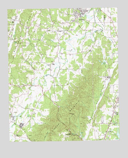
Kensington, GA USGS Topographic Map
Click on map above to begin viewing in our Map Viewer.

This topographic map contains these locations and features:
Feature Name Type Latitude Longitude GNIS ID View Map
Bailey BranchStreamN34.7751°W85.3527°310719View Map
Bailey CemeteryCemeteryN34.8312°W85.3047°310724View Map
Barwick Mill Dam OneDamN34.7717°W85.3616°337088View Map
Bethel ChurchChurchN34.8237°W85.3244°354632View Map
Bethlehem ChurchChurchN34.8540°W85.3291°353959View Map
Blue HoleSpringN34.8676°W85.2888°353964View Map
Brotherton CreekStreamN34.8212°W85.3205°311849View Map
Catlett GapGapN34.7609°W85.3072°355037View Map
Center Point CemeteryCemeteryN34.7745°W85.2536°353982View Map
Center Point ChurchChurchN34.7742°W85.2527°355085View Map
ChickamaugaPopulated PlaceN34.8712°W85.2908°355145View Map
Chickamauga City HallBuildingN34.8715°W85.2919°353994View Map
Chickamauga DivisionCivilN34.8614°W85.3341°1936177View Map
Chickamauga Elementary SchoolSchoolN34.8719°W85.2963°353995View Map
Chickamauga High School (historical)SchoolN34.8690°W85.2936°353996View Map
Chickamauga Police DepartmentBuildingN34.8698°W85.2933°2733535View Map
Chickamauga Post OfficePost OfficeN34.8720°W85.2886°353997View Map
Chickamauga Public LibraryBuildingN34.8734°W85.2919°353998View Map
Christian Home ChurchChurchN34.8573°W85.3391°355158View Map
Church of GodChurchN34.8742°W85.2950°354001View Map
City of ChickamaugaCivilN34.8744°W85.2890°2404044View Map
Coke Oven BranchStreamN34.8723°W85.2750°310340View Map
Cove ChurchChurchN34.8170°W85.3269°355352View Map
Crawfish CreekStreamN34.8523°W85.2672°355366View Map
Crawfish SpringSpringN34.8704°W85.2925°354012View Map
Crawfish Spring LakeLakeN34.8674°W85.2891°313090View Map
Crawfish ValleyValleyN34.8743°W85.2715°313091View Map
Crestlawn Memorial ParkCemeteryN34.7748°W85.2550°354013View Map
Davis CrossroadsPopulated PlaceN34.7554°W85.3680°331520View Map
District Hill CemeteryCemeteryN34.8528°W85.3033°313483View Map
Elizabeth Lee United Methodist ChurchChurchN34.8717°W85.2763°354051View Map
Estelle Station (historical)Populated PlaceN34.7520°W85.3527°354032View Map
Fellowship Baptist ChurchChurchN34.8740°W85.2900°354038View Map
First Presbyterian ChurchChurchN34.8748°W85.2941°354042View Map
Friendship ChurchChurchN34.8387°W85.3441°314433View Map
Garmany CemeteryCemeteryN34.8034°W85.3563°314517View Map
Garrett Chapel CemeteryCemeteryN34.8576°W85.3516°354057View Map
Garrett ChurchChurchN34.8565°W85.3511°355978View Map
Garrett School (historical)SchoolN34.8581°W85.3513°354058View Map
Gilbert LakeReservoirN34.7550°W85.2929°314592View Map
Glass Mill (historical)LocaleN34.8526°W85.2738°354062View Map
Gordon Lee High SchoolSchoolN34.8700°W85.2957°356056View Map
Gordon Lee Middle SchoolSchoolN34.8708°W85.2964°2545698View Map
Hall BranchStreamN34.7976°W85.3497°315029View Map
Hall MillPopulated PlaceN34.7834°W85.3558°356142View Map
Harding CemeteryCemeteryN34.7778°W85.3691°315122View Map
High PointPopulated PlaceN34.8634°W85.3669°356283View Map
High Point (historical)SchoolN34.8648°W85.3675°354080View Map
Howard LakeReservoirN34.7556°W85.2512°337091View Map
Jake Goodson CreekStreamN34.8526°W85.2680°316031View Map
Kendrick (historical)Populated PlaceN34.8462°W85.3713°354090View Map
KensingtonPopulated PlaceN34.7742°W85.3727°332139View Map
Kensington School (historical)SchoolN34.7820°W85.3736°354091View Map
Kensington United Methodist ChurchChurchN34.7770°W85.3722°354092View Map
Ketner BranchStreamN34.8373°W85.3141°316398View Map
Krystal LakeReservoirN34.8661°W85.2815°337095View Map
Krystal Lake DamDamN34.8651°W85.2833°337094View Map
Lawrence CemeteryCemeteryN34.8098°W85.2627°316693View Map
Long CoveValleyN34.8317°W85.2995°317346View Map
Lookout CemeteryCemeteryN34.8678°W85.3661°354109View Map
Lookout ChurchChurchN34.8648°W85.3655°317399View Map
Mill CreekStreamN34.7740°W85.3675°318234View Map
Mill CreekStreamN34.8498°W85.3680°318235View Map
New Friendship ChurchChurchN34.8392°W85.3583°354145View Map
NoblePopulated PlaceN34.7806°W85.2544°326423View Map
Oak Grove ChurchChurchN34.8529°W85.3261°319817View Map
Oak Grove School (historical)SchoolN34.8540°W85.3266°354153View Map
Old Bethel ChurchChurchN34.8345°W85.2813°319945View Map
Old Lookout CemeteryCemeteryN34.8523°W85.3750°319994View Map
Old Salem CemeteryCemeteryN34.7653°W85.2544°320022View Map
Owings CemeteryCemeteryN34.8320°W85.3122°320134View Map
Phillips SpringSpringN34.8429°W85.3672°320469View Map
Pittman BranchStreamN34.7895°W85.3450°320758View Map
Pond SpringPopulated PlaceN34.8223°W85.3255°332722View Map
Pond Spring Elementary School (historical)SchoolN34.8220°W85.3269°354174View Map
Pond Springs SchoolSchoolN34.8517°W85.3136°320997View Map
Porter CemeteryCemeteryN34.8170°W85.3280°321064View Map
Salem (historical)Populated PlaceN34.7659°W85.2600°354191View Map
Shaw BranchStreamN34.7551°W85.3725°322807View Map
Shaw CemeteryCemeteryN34.8026°W85.3075°322809View Map
Shields LakeReservoirN34.8248°W85.2654°337099View Map
Shields Lake DamDamN34.8251°W85.2650°337098View Map
Strickland BranchStreamN34.7859°W85.3491°323677View Map
The Cove CemeteryCemeteryN34.8176°W85.3280°354206View Map
The HillsRangeN34.8592°W85.3380°324046View Map
Tri-County Memorial GardensCemeteryN34.7590°W85.2613°324287View Map
Walker County Emergency Services Fire Station 19BuildingN34.8651°W85.3684°2605014View Map
Walker County Emergency Services Fire Station 6BuildingN34.8683°W85.2938°2604730View Map
Walker County Emergency Services Fire Station 9BuildingN34.7747°W85.3719°2604728View Map
Walker State PrisonBuildingN34.8095°W85.2619°354215View Map
Warren School (historical)SchoolN34.7504°W85.2683°354220View Map
Warrens (historical)Populated PlaceN34.7512°W85.2672°354221View Map
Wright Mineral SpringLocaleN34.7559°W85.3036°325574View Map

Note: Coordinates in the location and feature list above are referenced to NAD83 datum.


Copyright (C) 2008-2024 Ryan Niemi / Sunset Dynamics ... All Rights Reserved