TopoQuest Logo
Do you find TopoQuest useful?
Help keep TopoQuest running and adding new maps/features by donating!
Bitcoin:  19c7KJd3qBynnjoSw5npx9KScwjBe4ifkT
Litecoin:  LXs6TkuXGGXo1vDsWCkWVdjQX94eUKd6ui
Home View Maps Find Maps Find Places Resources & Links


Houlka, Mississippi Topographic Map

USGS Map Title: Houlka, MS
USGS Map MRC: 34089A1
DRG (GeoTIFF) Download: o34089a1.tif


Neighboring USGS Topographic Map Quads:


  Randolph, MS  
34089B2
 

  Southwest Pontotoc, MS  
34089B1
 

  Southeast Pontotoc, MS  
34088B8
 

  Robbs, MS  
34089A2
 

  Houlka, MS  
34089A1
 

  Troy, MS  
34088A8
 

  Vardaman, MS  
33089H2
 

  Houston West, MS  
33089H1
 

  Houston East, MS  
33088H8


Map MRC Location:

N35°
W90°
N35°
W89°
H8 H7 H6 H5 H4 H3 H2 H1
G8 G7 G6 G5 G4 G3 G2 G1
F8 F7 F6 F5 F4 F3 F2 F1
E8 E7 E6 E5 E4 E3 E2 E1
D8 D7 D6 D5 D4 D3 D2 D1
C8 C7 C6 C5 C4 C3 C2 C1
B8 B7 B6 B5 B4 B3 B2 B1
A8 A7 A6 A5 A4 A3 A2 A1
N34°
W90°
N34°
W89°

Houlka, MS USGS 1:24K Topographic Map Preview:
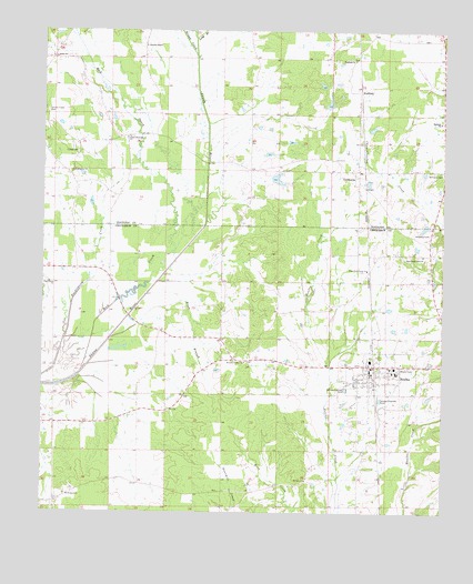
Houlka, MS USGS Topographic Map
Click on map above to begin viewing in our Map Viewer.

This topographic map contains these locations and features:
Feature Name Type Latitude Longitude GNIS ID View Map
Beckham SchoolSchoolN34.1012°W89.0014°666741View Map
Beckham Volunteer Fire DepartmentBuildingN34.1232°W89.0082°2665898View Map
Brush CreekStreamN34.1184°W89.0776°667667View Map
Buck BranchStreamN34.0451°W89.1037°667722View Map
Cooke CemeteryCemeteryN34.0934°W89.1145°668782View Map
Cooke Memorial ChurchChurchN34.0971°W89.0992°668783View Map
Corper Lake DamDamN34.0918°W89.0551°682456View Map
East County Line CemeteryCemeteryN34.0665°W89.0084°1805878View Map
East County Line ChurchChurchN34.0668°W89.0067°669568View Map
Estate Lake DamDamN34.0868°W89.0534°682455View Map
GershormPopulated PlaceN34.0887°W89.0267°670365View Map
Gershorm Baptist ChurchChurchN34.0854°W89.0284°706879View Map
Holladay CemeteryCemeteryN34.0723°W89.0042°671292View Map
HoulkaPopulated PlaceN34.0382°W89.0220°671516View Map
Houlka Baptist ChurchChurchN34.0368°W89.0156°710300View Map
Houlka Church of the NazareneChurchN34.0354°W89.0220°710301View Map
Houlka Elementary SchoolSchoolN34.0371°W89.0148°710302View Map
Houlka High SchoolSchoolN34.0368°W89.0145°710303View Map
Houlka Methodist ChurchChurchN34.0351°W89.0215°710304View Map
Houlka Police DepartmentBuildingN34.0371°W89.0225°2754110View Map
Houlka Post OfficePost OfficeN34.0372°W89.0227°2768674View Map
Houlka Presbyterian ChurchChurchN34.0379°W89.0170°710305View Map
Houlka Second Baptist ChurchChurchN34.0357°W89.0228°710306View Map
Houlka Volunteer Fire DepartmentBuildingN34.0373°W89.0221°2665921View Map
Indian Creek CemeteryCemeteryN34.1040°W89.1239°671691View Map
Judah ChurchChurchN34.1182°W89.1217°672045View Map
Long BranchStreamN34.1229°W89.0778°672811View Map
Mount Prospect ChurchChurchN34.0048°W89.1176°674255View Map
Mount Zion ChurchChurchN34.0087°W89.0426°674393View Map
Mud CreekStreamN34.0362°W89.1128°674433View Map
Oak Grove (historical)Populated PlaceN34.0448°W89.0695°688724View Map
Postoak Church (historical)ChurchN34.0521°W89.0520°688731View Map
Schonna ChapelChurchN34.1209°W89.0934°677455View Map
Schooner Valley Baptist ChurchChurchN34.0390°W89.0617°677457View Map
Schooner Valley School (historical)SchoolN34.0393°W89.0623°710372View Map
Skuna River Structure Y-22-9 DamDamN34.1068°W89.0367°682466View Map
Town of New HoulkaCivilN34.0363°W89.0211°2406976View Map
WallfieldPopulated PlaceN34.1093°W89.0270°692304View Map
Wallfield ChurchChurchN34.1176°W89.0281°679292View Map
Washington ChurchChurchN34.0884°W89.1162°679360View Map
West County Line ChurchChurchN34.0632°W89.0240°679478View Map
West Grove ChurchChurchN34.0596°W89.1228°679496View Map
Williams CemeteryCemeteryN34.0882°W89.0006°679710View Map

Note: Coordinates in the location and feature list above are referenced to NAD83 datum.


Copyright (C) 2008-2025 Ryan Niemi / Sunset Dynamics ... All Rights Reserved