TopoQuest Logo
Do you find TopoQuest useful?
Help keep TopoQuest running and adding new maps/features by donating!
Bitcoin:  19c7KJd3qBynnjoSw5npx9KScwjBe4ifkT
Litecoin:  LXs6TkuXGGXo1vDsWCkWVdjQX94eUKd6ui
Home View Maps Find Maps Find Places Resources & Links


Baie de Wasai, Michigan Topographic Map

USGS Map Title: Baie de Wasai, MI
USGS Map MRC: 46084D2
DRG (GeoTIFF) Download: o46084d2.tif


Neighboring USGS Topographic Map Quads:


  Payment, MI  
46084E2


  Sault Ste. Marie South, MI  
46084D3
 

  Baie de Wasai, MI  
46084D2


  Barbeau, MI  
46084C3
 

  Oak Ridge, MI  
46084C2


Map MRC Location:

N47°
W85°
N47°
W84°
H8 H7 H6 H5 H4 H3 H2 H1
G8 G7 G6 G5 G4 G3 G2 G1
F8 F7 F6 F5 F4 F3 F2 F1
E8 E7 E6 E5 E4 E3 E2 E1
D8 D7 D6 D5 D4 D3 D2 D1
C8 C7 C6 C5 C4 C3 C2 C1
B8 B7 B6 B5 B4 B3 B2 B1
A8 A7 A6 A5 A4 A3 A2 A1
N46°
W85°
N46°
W84°

Baie de Wasai, MI USGS 1:24K Topographic Map Preview:
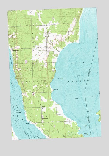
Baie de Wasai, MI USGS Topographic Map
Click on map above to begin viewing in our Map Viewer.

This topographic map contains these locations and features:
Feature Name Type Latitude Longitude GNIS ID View Map
Advance IslandIslandN46.3781°W84.1445°619853View Map
Bai-de-wasai CemeteryCemeteryN46.4614°W84.2333°2356455View Map
Baie de WasaiPopulated PlaceN46.4614°W84.2448°620440View Map
Baie de Wasai Post Office (historical)Post OfficeN46.4614°W84.2447°2356362View Map
Farmers HallBuildingN46.4125°W84.2073°625836View Map
Finnish CemeteryCemeteryN46.3806°W84.1842°2356452View Map
Gem IslandIslandN46.4325°W84.1773°626710View Map
Gem Island CemeteryCemeteryN46.4333°W84.1917°2356440View Map
Hay PointCapeN46.4664°W84.1528°627977View Map
Hiawatha SchoolSchoolN46.4056°W84.2073°628182View Map
Lake GeorgeLakeN46.4500°W84.1334°1623177View Map
Lake NicoletLakeN46.4167°W84.2417°633401View Map
Little Rapids ChannelChannelN46.4100°W84.2431°1617993View Map
Ninemile PointCapeN46.3917°W84.2264°633426View Map
Rock Bottom CreekStreamN46.4536°W84.1811°636076View Map
Rock IslandIslandN46.3864°W84.1459°636081View Map
Sacred Heart ChurchChurchN46.4625°W84.2448°636465View Map
Saints John and Anne ChurchChurchN46.3936°W84.2075°637096View Map
Sault Sainte Marie ReservationCivilN46.4720°W84.2123°2419132View Map
Sugar IslandIslandN46.4334°W84.2167°639020View Map
Sugar Island Ambulance Corporation / Sugar Island Volunteer Fire DepartmentBuildingN46.4848°W84.2296°2626997View Map
Sugar Island Leading LightLocaleN46.4128°W84.2334°1617167View Map
Township of Sugar IslandCivilN46.4434°W84.1897°1627131View Map
WCMZ-FM (Sault Sainte Marie)TowerN46.4861°W84.2303°1625492View Map
Whipple PointCapeN46.4217°W84.1898°1616283View Map
Wilmar CreekStreamN46.4584°W84.1775°1616549View Map
Wilwalk CemeteryCemeteryN46.3939°W84.2069°2356423View Map

Note: Coordinates in the location and feature list above are referenced to NAD83 datum.


Copyright (C) 2008-2025 Ryan Niemi / Sunset Dynamics ... All Rights Reserved