TopoQuest Logo
Do you find TopoQuest useful?
Help keep TopoQuest running and adding new maps/features by donating!
Bitcoin:  19c7KJd3qBynnjoSw5npx9KScwjBe4ifkT
Litecoin:  LXs6TkuXGGXo1vDsWCkWVdjQX94eUKd6ui
Home View Maps Find Maps Find Places Resources & Links


Oak Ridge, Michigan Topographic Map

USGS Map Title: Oak Ridge, MI
USGS Map MRC: 46084C2
DRG (GeoTIFF) Download: o46084c2.tif


Neighboring USGS Topographic Map Quads:


  Sault Ste. Marie South, MI  
46084D3
 

  Baie de Wasai, MI  
46084D2


  Barbeau, MI  
46084C3
 

  Oak Ridge, MI  
46084C2


  Pickford, MI  
46084B3
 

  Munuscong, MI  
46084B2
 

  Munuscong NE, MI  
46084B1


Map MRC Location:

N47°
W85°
N47°
W84°
H8 H7 H6 H5 H4 H3 H2 H1
G8 G7 G6 G5 G4 G3 G2 G1
F8 F7 F6 F5 F4 F3 F2 F1
E8 E7 E6 E5 E4 E3 E2 E1
D8 D7 D6 D5 D4 D3 D2 D1
C8 C7 C6 C5 C4 C3 C2 C1
B8 B7 B6 B5 B4 B3 B2 B1
A8 A7 A6 A5 A4 A3 A2 A1
N46°
W85°
N46°
W84°

Oak Ridge, MI USGS 1:24K Topographic Map Preview:
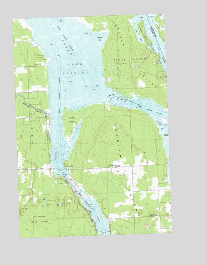
Oak Ridge, MI USGS Topographic Map
Click on map above to begin viewing in our Map Viewer.

This topographic map contains these locations and features:
Feature Name Type Latitude Longitude GNIS ID View Map
Catholic CemeteryCemeteryN46.2581°W84.1756°2356443View Map
Charlotte RiverStreamN46.3186°W84.2206°623118View Map
Chicken IslandsIslandN46.3067°W84.1278°623182View Map
Deer LakeLakeN46.2712°W84.2269°624482View Map
Duck IslandIslandN46.3639°W84.1428°624922View Map
Duck Island CemeteryCemeteryN46.3583°W84.1367°2356454View Map
Duck LakeLakeN46.3625°W84.1472°624942View Map
Dunbar Forest Experiment Station Michigan State UniversitySchoolN46.3197°W84.2284°1617210View Map
Dunbar ParkParkN46.3200°W84.2214°624978View Map
East Neebish ChannelChannelN46.3459°W84.1256°625237View Map
Elisha PointCapeN46.3461°W84.1286°625439View Map
Field PointCapeN46.2917°W84.1253°625933View Map
Franklin's AirportAirportN46.2653°W84.1264°1617225View Map
Haynes Family CemeteryCemeteryN46.2634°W84.1939°2774390View Map
Hen IslandIslandN46.3142°W84.1331°628099View Map
Indian PointCapeN46.3520°W84.1306°1623105View Map
Laitinen Family CemeteryCemeteryN46.2611°W84.1667°2356433View Map
Lower Nicolet RangesLocaleN46.3214°W84.1720°1617216View Map
Middle Neebish ChannelChannelN46.3392°W84.1878°632268View Map
Middle Neebish Channel RangeLocaleN46.3378°W84.2056°1617212View Map
Muskrat LakeLakeN46.2680°W84.2278°633179View Map
Neebish IslandIslandN46.2834°W84.1584°633255View Map
Neebish Island Presbyterian CemeteryCemeteryN46.2556°W84.1333°2356430View Map
Neebish Island Volunteer Fire DepartmentBuildingN46.2602°W84.1367°2627059View Map
Oak RidgePopulated PlaceN46.2886°W84.2100°633857View Map
Oak Ridge Park Post Office (historical)Post OfficeN46.2886°W84.2100°2354350View Map
Oak Ridge Park SchoolLocaleN46.2886°W84.1659°633861View Map
Roach LakeLakeN46.2687°W84.2156°636024View Map
Sand IslandIslandN46.3161°W84.2048°637181View Map
Shingle BayBayN46.3620°W84.1789°637806View Map
Shingle PointCapeN46.3656°W84.1845°637809View Map
Stone School District Number 4SchoolN46.2597°W84.1367°638880View Map
Township of SooCivilN46.3097°W84.1957°1627091View Map
West Neebish ChannelChannelN46.3059°W84.2153°1616153View Map
West Neebish Channel RangeLocaleN46.2800°W84.2161°1617214View Map
West Noebish Channel Upper RangeLocaleN46.3228°W84.1956°1617211View Map

Note: Coordinates in the location and feature list above are referenced to NAD83 datum.


Copyright (C) 2008-2025 Ryan Niemi / Sunset Dynamics ... All Rights Reserved