TopoQuest Logo
Do you find TopoQuest useful?
Help keep TopoQuest running and adding new maps/features by donating!
Bitcoin:  19c7KJd3qBynnjoSw5npx9KScwjBe4ifkT
Litecoin:  LXs6TkuXGGXo1vDsWCkWVdjQX94eUKd6ui
Home View Maps Find Maps Find Places Resources & Links


Howey In The Hills, Florida Topographic Map

USGS Map Title: Howey In The Hills, FL
USGS Map MRC: 28081F7
DRG (GeoTIFF) Download: o28081f7.tif


Neighboring USGS Topographic Map Quads:


  Leesburg West, FL  
28081G8
 

  Leesburg East, FL  
28081G7
 

  Eustis, FL  
28081G6
 

  Center Hill, FL  
28081F8
 

  Howey In The Hills, FL  
28081F7
 

  Astatula, FL  
28081F6
 

  Mascotte, FL  
28081E8
 

  Clermont West, FL  
28081E7
 

  Clermont East, FL  
28081E6


Map MRC Location:

N29°
W82°
N29°
W81°
H8 H7 H6 H5 H4 H3 H2 H1
G8 G7 G6 G5 G4 G3 G2 G1
F8 F7 F6 F5 F4 F3 F2 F1
E8 E7 E6 E5 E4 E3 E2 E1
D8 D7 D6 D5 D4 D3 D2 D1
C8 C7 C6 C5 C4 C3 C2 C1
B8 B7 B6 B5 B4 B3 B2 B1
A8 A7 A6 A5 A4 A3 A2 A1
N28°
W82°
N28°
W81°

Howey In The Hills, FL USGS 1:24K Topographic Map Preview:
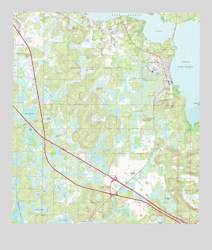
Howey In The Hills, FL USGS Topographic Map
Click on map above to begin viewing in our Map Viewer.

This topographic map contains these locations and features:
Feature Name Type Latitude Longitude GNIS ID View Map
Allen Pierce CemeteryCemeteryN28.7397°W81.8045°2462613View Map
Bird LakeLakeN28.6436°W81.8545°293936View Map
Blue Spring LakeLakeN28.7072°W81.8174°293939View Map
Blue SpringsSpringN28.7486°W81.8276°293940View Map
Booths IslandIslandN28.6547°W81.7756°294328View Map
Church LakeLakeN28.6442°W81.8417°293965View Map
Church of God by FaithChurchN28.7384°W81.8089°2452871View Map
Church of God by Faith CemeteryCemeteryN28.7383°W81.8088°2768087View Map
City of LeesburgCivilN28.7420°W81.8631°2404907View Map
Community Church of Howey in the HillsChurchN28.7174°W81.7736°2449349View Map
Crown LakeLakeN28.6600°W81.8604°2557334View Map
Dilly LakeLakeN28.6806°W81.8630°293986View Map
Dilly MarshSwampN28.6852°W81.8638°293987View Map
Florida Flying Gators Ultralight AirportAirportN28.6278°W81.8026°309700View Map
God's Holy TabernacleChurchN28.7361°W81.8092°2462611View Map
Grand Haven Golf ClubLocaleN28.7366°W81.7928°2449345View Map
Grand Palms Golf and Country ClubLocaleN28.7289°W81.7964°2449346View Map
Grande Oaks Golf ClubLocaleN28.7366°W81.7928°2449347View Map
Griffin Stormwater ParkParkN28.7142°W81.7700°2462653View Map
Howey - in - the - Hills City LibraryBuildingN28.7135°W81.7730°2449344View Map
Howey AcademySchoolN28.7094°W81.7706°294215View Map
Howey In the Hills Police DepartmentBuildingN28.7140°W81.7731°2331522View Map
Howey in the Hills Post OfficePost OfficeN28.7122°W81.7753°2449348View Map
Howey Landing Strip (historical)AirportN28.7028°W81.7748°294583View Map
Howey StationLocaleN28.7180°W81.7845°303676View Map
Howey Substation-Florida PowerBuildingN28.7114°W81.7806°2462649View Map
Howey-In-The-Hills Post OfficePost OfficeN28.7072°W81.7753°2462617View Map
Howey-In-The-Hills Town HallBuildingN28.7139°W81.7744°2462658View Map
Howey-In-The-Hills Water TowerTowerN28.7128°W81.7761°2462618View Map
Howey-in-the-Hills-Okahumpka DivisionCivilN28.7185°W81.8582°1935801View Map
Howie In The HillsPopulated PlaceN28.7169°W81.7734°295002View Map
Indian River PlazaLocaleN28.7217°W81.7759°296032View Map
Interchange 27CrossingN28.6517°W81.8067°294042View Map
Lake Annabelle ReedLakeN28.6868°W81.7709°2071416View Map
Lake ArthurLakeN28.6269°W81.8399°293915View Map
Lake BerthaLakeN28.6952°W81.7698°293927View Map
Lake County Fire Rescue Station 76BuildingN28.7431°W81.8079°2331247View Map
Lake County Fire Rescue Station 82BuildingN28.7106°W81.8607°2331253View Map
Lake IllinoisLakeN28.7145°W81.7775°294039View Map
Lake JewelLakeN28.6679°W81.8643°2567588View Map
Lake LucilleLakeN28.6873°W81.8509°294064View Map
Lake MargarettaLakeN28.7424°W81.8362°294068View Map
Lake MonarchLakeN28.6588°W81.8639°2567589View Map
Leesburg Water TowerTowerN28.7358°W81.8675°2467525View Map
Little EvergladesSwampN28.6514°W81.7929°294056View Map
Little Lake HarrisLakeN28.7197°W81.7540°294058View Map
Marianne Beck Memorial LibraryBuildingN28.7139°W81.7736°2462616View Map
Memorial BridgeBridgeN28.7392°W81.7667°294080View Map
Montgomery LakeLakeN28.6387°W81.7713°294088View Map
Moon LakeLakeN28.6337°W81.8554°294089View Map
Mount Bethel Baptist ChurchChurchN28.7472°W81.8542°294091View Map
Mulehead LakeLakeN28.6772°W81.8465°294094View Map
Orange BlossomPopulated PlaceN28.6881°W81.7865°294110View Map
Pumpkin CenterPopulated PlaceN28.7183°W81.8292°294899View Map
Pumpkin Center LakeLakeN28.7142°W81.8281°294125View Map
Royal LakeLakeN28.6635°W81.8568°2557338View Map
Saint Matthews Church of God by FaithChurchN28.7386°W81.8089°2462612View Map
Sap PondLakeN28.7336°W81.8251°294145View Map
South Lake Christian ChurchChurchN28.6311°W81.8497°2467527View Map
Southpointe Baptist FellowshipChurchN28.7244°W81.8611°2467526View Map
Spanish Village Mobile Home ParkPopulated PlaceN28.7070°W81.8603°2450491View Map
Tabernacle of Faith - Holy Ghost in the HillsChurchN28.6772°W81.7783°2462656View Map
Taylor Memorial CemeteryCemeteryN28.7020°W81.7790°294171View Map
Town of Howey-in-the-HillsCivilN28.7098°W81.7798°2405870View Map
Trout LakeLakeN28.6697°W81.7780°294177View Map
Turkey LakeLakeN28.7011°W81.8506°294180View Map
Twin LakesLakeN28.7240°W81.8279°294182View Map
Woodlands at Church Lake Mobile Home ParkPopulated PlaceN28.6458°W81.8358°2449266View Map
YalahaPopulated PlaceN28.7386°W81.8087°294203View Map
Yalaha Community ChurchChurchN28.7467°W81.8033°2462614View Map
Yalaha Post OfficePost OfficeN28.7419°W81.8093°2462610View Map

Note: Coordinates in the location and feature list above are referenced to NAD83 datum.


Copyright (C) 2008-2025 Ryan Niemi / Sunset Dynamics ... All Rights Reserved