TopoQuest Logo
Do you find TopoQuest useful?
Help keep TopoQuest running and adding new maps/features by donating!
Bitcoin:  19c7KJd3qBynnjoSw5npx9KScwjBe4ifkT
Litecoin:  LXs6TkuXGGXo1vDsWCkWVdjQX94eUKd6ui
Home View Maps Find Maps Find Places Resources & Links


Hubbardston, Michigan Topographic Map

USGS Map Title: Hubbardston, MI
USGS Map MRC: 43084A7
DRG (GeoTIFF) Download: o43084a7.tif


Neighboring USGS Topographic Map Quads:


  Butternut, MI  
43084B8
 

  Carson City, MI  
43084B7
 

  Perrinton, MI  
43084B6
 

  Palo, MI  
43084A8
 

  Hubbardston, MI  
43084A7
 

  Maple Rapids, MI  
43084A6
 

  Portland North, MI  
42084H8
 

  Westphalia, MI  
42084H7
 

  Riley, MI  
42084H6


Map MRC Location:

N44°
W85°
N44°
W84°
H8 H7 H6 H5 H4 H3 H2 H1
G8 G7 G6 G5 G4 G3 G2 G1
F8 F7 F6 F5 F4 F3 F2 F1
E8 E7 E6 E5 E4 E3 E2 E1
D8 D7 D6 D5 D4 D3 D2 D1
C8 C7 C6 C5 C4 C3 C2 C1
B8 B7 B6 B5 B4 B3 B2 B1
A8 A7 A6 A5 A4 A3 A2 A1
N43°
W85°
N43°
W84°

Hubbardston, MI USGS 1:24K Topographic Map Preview:
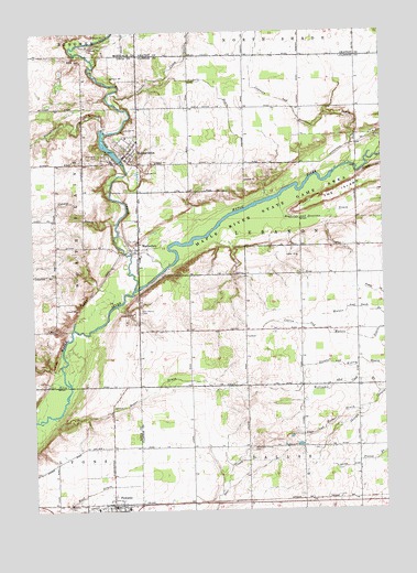
Hubbardston, MI USGS Topographic Map
Click on map above to begin viewing in our Map Viewer.

This topographic map contains these locations and features:
Feature Name Type Latitude Longitude GNIS ID View Map
Blue Pine DairyLocaleN43.0336°W84.7769°2725010View Map
Bower DrainCanalN43.0289°W84.8369°621799View Map
Connor DrainCanalN43.0809°W84.8614°623710View Map
Connors and Sessions DrainCanalN43.1081°W84.7897°623712View Map
East Plains CemeteryCemeteryN43.0517°W84.8364°625245View Map
Fifield CreekStreamN43.1092°W84.8461°625939View Map
Fish CreekStreamN43.0575°W84.8389°626029View Map
Fitzpatrick FarmsLocaleN43.0694°W84.7633°2725016View Map
HubbardstonPopulated PlaceN43.0923°W84.8422°628745View Map
Hubbardston - North Plains Fire DepartmentBuildingN43.0925°W84.8414°2636071View Map
Hubbardston East CemeteryCemeteryN43.0928°W84.8372°2581775View Map
Hubbardston Post OfficePost OfficeN43.0917°W84.8425°2582390View Map
Huckleberry Creek Golf CourseLocaleN43.0253°W84.8431°2582367View Map
Maple River CampgroundLocaleN43.0617°W84.8278°2573879View Map
MathertonPopulated PlaceN43.0684°W84.8369°631733View Map
Matherton Post Office (historical)Post OfficeN43.0681°W84.8375°2581743View Map
Most Holy Trinity CemeteryCemeteryN43.0159°W84.7975°632758View Map
Nichols DrainCanalN43.1111°W84.8103°633388View Map
PewamoPopulated PlaceN43.0011°W84.8469°634746View Map
Pewamo CemeteryCemeteryN43.0014°W84.8633°634747View Map
Pewamo Elementary SchoolSchoolN43.0006°W84.8528°2582366View Map
Pewamo Fire DepartmentBuildingN43.0007°W84.8478°2636074View Map
Pewamo Post OfficePost OfficeN43.0011°W84.8467°2582363View Map
Pewamo Station (historical)LocaleN43.0014°W84.8478°2582362View Map
Reynolds and Sessions DrainCanalN43.0814°W84.7578°635822View Map
Ruel DrainCanalN43.0025°W84.8608°636366View Map
Sage and Hafner DrainCanalN43.0223°W84.7689°636491View Map
Saint John the Baptist Cemetery Historical MarkerParkN43.0941°W84.8400°2567811View Map
Saint John the Baptist Church Historical MarkerParkN43.0941°W84.8400°2567810View Map
Saint Johns CemeteryCemeteryN43.0925°W84.8486°636722View Map
Saint Joseph's ChurchChurchN43.0008°W84.8422°2582364View Map
Saint Joseph's Elementary SchoolSchoolN43.0006°W84.8422°2582365View Map
Sharps DrainCanalN43.0248°W84.7567°637678View Map
Stewart and Kinley DrainCanalN43.0378°W84.7650°638826View Map
Stoughton CreekStreamN43.0992°W84.8506°638929View Map
Township of LebanonCivilN43.0754°W84.7783°1626597View Map
Village of HubbardstonCivilN43.0939°W84.8413°2398553View Map
Village of PewamoCivilN43.0020°W84.8473°2399660View Map
Waters and Nash DrainCanalN43.0523°W84.7561°1615854View Map
West Side CemeteryCemeteryN43.0928°W84.8506°1616177View Map
Williams and Cook DrainCanalN43.0309°W84.7703°1616498View Map

Note: Coordinates in the location and feature list above are referenced to NAD83 datum.


Copyright (C) 2008-2024 Ryan Niemi / Sunset Dynamics ... All Rights Reserved