TopoQuest Logo
Do you find TopoQuest useful?
Help keep TopoQuest running and adding new maps/features by donating!
Bitcoin:  19c7KJd3qBynnjoSw5npx9KScwjBe4ifkT
Litecoin:  LXs6TkuXGGXo1vDsWCkWVdjQX94eUKd6ui
Home View Maps Find Maps Find Places Resources & Links


Riley, Michigan Topographic Map

USGS Map Title: Riley, MI
USGS Map MRC: 42084H6
DRG (GeoTIFF) Download: o42084h6.tif


Neighboring USGS Topographic Map Quads:


  Hubbardston, MI  
43084A7
 

  Maple Rapids, MI  
43084A6
 

  Saint Johns North, MI  
43084A5
 

  Westphalia, MI  
42084H7
 

  Riley, MI  
42084H6
 

  Saint Johns South, MI  
42084H5
 

  Eagle, MI  
42084G7
 

  Wacousta, MI  
42084G6
 

  Lansing North, MI  
42084G5


Map MRC Location:

N43°
W85°
N43°
W84°
H8 H7 H6 H5 H4 H3 H2 H1
G8 G7 G6 G5 G4 G3 G2 G1
F8 F7 F6 F5 F4 F3 F2 F1
E8 E7 E6 E5 E4 E3 E2 E1
D8 D7 D6 D5 D4 D3 D2 D1
C8 C7 C6 C5 C4 C3 C2 C1
B8 B7 B6 B5 B4 B3 B2 B1
A8 A7 A6 A5 A4 A3 A2 A1
N42°
W85°
N42°
W84°

Riley, MI USGS 1:24K Topographic Map Preview:
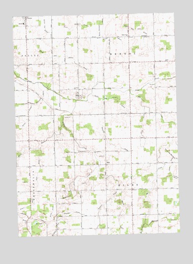
Riley, MI USGS Topographic Map
Click on map above to begin viewing in our Map Viewer.

This topographic map contains these locations and features:
Feature Name Type Latitude Longitude GNIS ID View Map
Anne Char FarmsLocaleN42.9717°W84.7136°2725004View Map
Bad CreekStreamN42.9567°W84.6605°620424View Map
Bengal Center SchoolSchoolN42.9875°W84.6608°621092View Map
Bengal Post Office (historical)Post OfficeN42.9456°W84.7114°2573860View Map
Boughton CemeteryCemeteryN42.9223°W84.7056°621770View Map
Bray CemeteryCemeteryN42.9593°W84.6416°621908View Map
Circle K Farm and RanchLocaleN42.8978°W84.7458°2725238View Map
Cloverbrook FarmLocaleN42.9453°W84.6400°2725193View Map
Double M FarmLocaleN42.9592°W84.6358°2725194View Map
Evert and Stewart DrainCanalN42.9936°W84.6925°625717View Map
Feneis DrainCanalN42.8923°W84.7414°625888View Map
Flegler FarmsLocaleN42.9228°W84.6625°2725221View Map
Forest Hill AirportAirportN42.9119°W84.6740°2650896View Map
Fowler High SchoolSchoolN42.9792°W84.7417°2573672View Map
Georgia CemeteryCemeteryN42.9437°W84.6367°626744View Map
Granger DrainCanalN42.9878°W84.6714°627134View Map
Halstead DrainCanalN42.8828°W84.6336°627664View Map
Harper SchoolSchoolN42.9728°W84.6328°627821View Map
Jacob DrainCanalN42.9109°W84.6314°628917View Map
Jason Corners FarmLocaleN42.9133°W84.6436°2725203View Map
Kelley DrainCanalN42.8761°W84.7428°629519View Map
Lyon and Dean DrainCanalN42.9911°W84.6536°631239View Map
M M FarmsLocaleN42.9042°W84.6819°2725210View Map
Mud LakeLakeN42.8829°W84.7364°632950View Map
Muskrat CreekStreamN42.9520°W84.7025°633170View Map
Nuffer and Sturgis DrainCanalN42.9525°W84.6764°633781View Map
Oak Ridge CemeteryCemeteryN42.9584°W84.7047°633859View Map
Oral Post Office (historical)Post OfficeN42.9294°W84.6306°2573843View Map
RileyPopulated PlaceN42.9150°W84.6805°635930View Map
Riley Elementary SchoolSchoolN42.9000°W84.6397°2573663View Map
Riley Post Office (historical)Post OfficeN42.9150°W84.6806°2573839View Map
Rochol Extension DrainCanalN42.9456°W84.7494°636072View Map
Rock N Oak DairyLocaleN42.9928°W84.7181°2725007View Map
Saint Paul's CemeteryCemeteryN42.9505°W84.7390°637000View Map
Saint Peter Lutheran ChurchChurchN42.9222°W84.7014°2573664View Map
Saint Peter's Lutheran CemeteryCemeteryN42.9231°W84.7014°2573874View Map
Saint Peters SchoolSchoolN42.9225°W84.7003°637021View Map
Schneider Dairy FarmLocaleN42.9886°W84.7025°2725120View Map
Schrader DairyLocaleN42.9092°W84.7044°2725127View Map
Schrader FarmLocaleN42.8994°W84.6822°2725128View Map
Schroeder DrainCanalN42.8875°W84.7111°637436View Map
Silm DrainCanalN42.9353°W84.6519°637897View Map
Smith and Sutton DrainCanalN42.9767°W84.7114°638129View Map
Sweetgrass FarmLocaleN42.9061°W84.6797°2725218View Map
Thelen DrainCanalN42.9425°W84.7392°1614724View Map
Tibbetts DrainCanalN42.8842°W84.6867°1614851View Map
Township of BengalCivilN42.9876°W84.6608°1625912View Map
Township of RileyCivilN42.9002°W84.6611°1626981View Map
Trent DrainCanalN42.9142°W84.7314°1615060View Map
Vacottage HeliportAirportN42.9586°W84.6403°1623919View Map
Wandeil DrainCanalN42.9295°W84.6792°1615760View Map
Watson DrainCanalN42.8870°W84.6658°1615874View Map
Westphalia and Riley DrainCanalN42.8778°W84.7203°1616226View Map

Note: Coordinates in the location and feature list above are referenced to NAD83 datum.


Copyright (C) 2008-2024 Ryan Niemi / Sunset Dynamics ... All Rights Reserved