TopoQuest Logo
Do you find TopoQuest useful?
Help keep TopoQuest running and adding new maps/features by donating!
Bitcoin:  19c7KJd3qBynnjoSw5npx9KScwjBe4ifkT
Litecoin:  LXs6TkuXGGXo1vDsWCkWVdjQX94eUKd6ui
Home View Maps Find Maps Find Places Resources & Links


Humphreys, Louisiana Topographic Map

USGS Map Title: Humphreys, LA
USGS Map MRC: 29090E7
DRG (GeoTIFF) Download: o29090e7.tif


Neighboring USGS Topographic Map Quads:


  Gibson, LA  
29090F8
 

  Gray, LA  
29090F7
 

  Savoie, LA  
29090F6
 

  Bayou Cocodrie, LA  
29090E8
 

  Humphreys, LA  
29090E7
 

  Houma, LA  
29090E6
 

  Lake Penchant, LA  
29090D8
 

  Lake Theriot, LA  
29090D7
 

  Dulac, LA  
29090D6


Map MRC Location:

N30°
W91°
N30°
W90°
H8 H7 H6 H5 H4 H3 H2 H1
G8 G7 G6 G5 G4 G3 G2 G1
F8 F7 F6 F5 F4 F3 F2 F1
E8 E7 E6 E5 E4 E3 E2 E1
D8 D7 D6 D5 D4 D3 D2 D1
C8 C7 C6 C5 C4 C3 C2 C1
B8 B7 B6 B5 B4 B3 B2 B1
A8 A7 A6 A5 A4 A3 A2 A1
N29°
W91°
N29°
W90°

Humphreys, LA USGS 1:24K Topographic Map Preview:
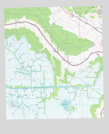
Humphreys, LA USGS Topographic Map
Click on map above to begin viewing in our Map Viewer.

This topographic map contains these locations and features:
Feature Name Type Latitude Longitude GNIS ID View Map
Bayou Black Elementary SchoolSchoolN29.6081°W90.8546°1629574View Map
Bayou Black Volunteer Fire DepartmentBuildingN29.5850°W90.8157°2332596View Map
Bayou CaneStreamN29.6135°W90.7731°532482View Map
Bayou CanePopulated PlaceN29.6241°W90.7512°1867280View Map
Bayou Cane Census Designated PlaceCensusN29.6244°W90.7510°2402668View Map
CrescentPopulated PlaceN29.6141°W90.7909°543115View Map
Crescent Farms Oil and Gas FieldOilfieldN29.6202°W90.8065°554121View Map
Duplantis CanalCanalN29.5219°W90.7548°534658View Map
Hanson CanalCanalN29.6197°W90.8568°535521View Map
Hatch PointFlatN29.5213°W90.8259°535557View Map
HollywoodPopulated PlaceN29.6002°W90.7581°543306View Map
Hollywood Oil and Gas FieldOilfieldN29.5824°W90.7920°535740View Map
Huffaker FieldAirportN29.6102°W90.8030°2676796View Map
HumphreysPopulated PlaceN29.6088°W90.8568°543317View Map
Humphreys Oil and Gas FieldOilfieldN29.5835°W90.8670°554800View Map
Lake HatchBayN29.5156°W90.7984°554677View Map
Lake Hatch Oil and Gas FieldOilfieldN29.5249°W90.8431°536283View Map
MandalayPopulated PlaceN29.5660°W90.7712°543440View Map
Mandalay National Wildlife RefugeParkN29.5263°W90.8027°2765385View Map
Mandalay National Wildlife RefugeReserveN29.5288°W90.7993°1958472View Map
Maria Immacolata ChurchChurchN29.6012°W90.7505°2602246View Map
Orange Grove Oil and Gas FieldOilfieldN29.5566°W90.8459°555569View Map
Ouiski BayouStreamN29.6069°W90.7715°537910View Map
Parish Governing Authority District J (historical)CivilN29.5647°W90.8318°1930335View Map
Saint Anthonys ChurchChurchN29.5755°W90.8106°538808View Map
Saint Lukes ChurchChurchN29.5655°W90.7998°538954View Map
Sunrise Oil and Gas FieldOilfieldN29.5302°W90.7809°556175View Map
The Church of Jesus Christ of Latter Day SaintsChurchN29.6210°W90.7995°2602856View Map
Ward NineCivilN29.5780°W90.8006°545227View Map
Ward TwoCivilN29.6030°W90.7665°545220View Map
WaterproofPopulated PlaceN29.5630°W90.7951°540254View Map

Note: Coordinates in the location and feature list above are referenced to NAD83 datum.


Copyright (C) 2008-2025 Ryan Niemi / Sunset Dynamics ... All Rights Reserved