TopoQuest Logo
Do you find TopoQuest useful?
Help keep TopoQuest running and adding new maps/features by donating!
Bitcoin:  19c7KJd3qBynnjoSw5npx9KScwjBe4ifkT
Litecoin:  LXs6TkuXGGXo1vDsWCkWVdjQX94eUKd6ui
Home View Maps Find Maps Find Places Resources & Links


Hutchinson SE, Kansas Topographic Map

USGS Map Title: Hutchinson SE, KS
USGS Map MRC: 38097A7
DRG (GeoTIFF) Download: o38097a7.tif


Neighboring USGS Topographic Map Quads:


  Hutchinson NW, KS  
38097B8
 

  Buhler, KS  
38097B7
 

  Halstead NW, KS  
38097B6
 

  Hutchinson, KS  
38097A8
 

  Hutchinson SE, KS  
38097A7
 

  Burrton, KS  
38097A6
 

  Elmer, KS  
37097H8
 

  Haven, KS  
37097H7
 

  Patterson, KS  
37097H6


Map MRC Location:

N39°
W98°
N39°
W97°
H8 H7 H6 H5 H4 H3 H2 H1
G8 G7 G6 G5 G4 G3 G2 G1
F8 F7 F6 F5 F4 F3 F2 F1
E8 E7 E6 E5 E4 E3 E2 E1
D8 D7 D6 D5 D4 D3 D2 D1
C8 C7 C6 C5 C4 C3 C2 C1
B8 B7 B6 B5 B4 B3 B2 B1
A8 A7 A6 A5 A4 A3 A2 A1
N38°
W98°
N38°
W97°

Hutchinson SE, KS USGS 1:24K Topographic Map Preview:
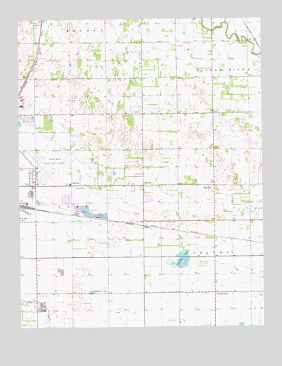
Hutchinson SE, KS USGS Topographic Map
Click on map above to begin viewing in our Map Viewer.

This topographic map contains these locations and features:
Feature Name Type Latitude Longitude GNIS ID View Map
Bethany Church of the NazareneChurchN38.0581°W97.8114°477978View Map
Cottonwood Hills Golf ClubLocaleN38.0663°W97.7697°2694487View Map
Heart MinistriesChurchN38.0490°W97.7580°2690107View Map
Hutchinson Fire Department Station 7BuildingN38.0869°W97.8696°2111440View Map
Hutchinson Regional AirportAirportN38.0631°W97.8656°477976View Map
Kansas Underground Salt MuseumBuildingN38.0437°W97.8676°2694275View Map
Kent (historical)LocaleN38.0403°W97.8114°481917View Map
Kent Post Office (historical)Post OfficeN38.0403°W97.8114°1954381View Map
KPTS-TV (Hutchinson)TowerN38.0558°W97.7767°481608View Map
KSCW - TV (Burrton)BuildingN38.0605°W97.7638°2625250View Map
KSKU-FM (Hutchinson)TowerN38.0558°W97.7767°481530View Map
KTVH-TV (Hutchinson)TowerN38.0611°W97.7639°481615View Map
KWCH - TV (Burrton)BuildingN38.0605°W97.7638°2625246View Map
Magwire LakeLakeN38.0147°W97.8384°477979View Map
New Hope Baptist ChurchChurchN38.0569°W97.8478°2688743View Map
Obee Elementary SchoolSchoolN38.0581°W97.8491°2497483View Map
ObeevillePopulated PlaceN38.0575°W97.8489°477977View Map
Prairie Dunes Country ClubLocaleN38.0912°W97.8479°2694523View Map
Prairie Hills Middle SchoolSchoolN38.0887°W97.8658°2497354View Map
Punkin CenterPopulated PlaceN38.0139°W97.7753°484832View Map
Showalter Mobile Home ParkPopulated PlaceN38.0873°W97.8142°2694160View Map
Township of ClayCivilN38.0574°W97.8392°473660View Map
Township of ValleyCivilN38.0038°W97.7531°473669View Map
Victory Village Christian AcademySchoolN38.0489°W97.7579°2497626View Map

Note: Coordinates in the location and feature list above are referenced to NAD83 datum.


Copyright (C) 2008-2024 Ryan Niemi / Sunset Dynamics ... All Rights Reserved