TopoQuest Logo
Do you find TopoQuest useful?
Help keep TopoQuest running and adding new maps/features by donating!
Bitcoin:  19c7KJd3qBynnjoSw5npx9KScwjBe4ifkT
Litecoin:  LXs6TkuXGGXo1vDsWCkWVdjQX94eUKd6ui
Home View Maps Find Maps Find Places Resources & Links


Intake, Montana Topographic Map

USGS Map Title: Intake, MT
USGS Map MRC: 47104C5
DRG (GeoTIFF) Download: o47104c5.tif


Neighboring USGS Topographic Map Quads:


  Intake NW, MT  
47104D6
 

  Allard Ranch, MT  
47104D5
 

  Knife River Mine, MT  
47104D4
 

  Kolberg Ranch, MT  
47104C6
 

  Intake, MT  
47104C5
 

  Savage SW, MT  
47104C4
 

  Stipek, MT  
47104B6
 

  Belle Prairie, MT  
47104B5
 

  Cluster Buttes NW, MT  
47104B4


Map MRC Location:

N48°
W105°
N48°
W104°
H8 H7 H6 H5 H4 H3 H2 H1
G8 G7 G6 G5 G4 G3 G2 G1
F8 F7 F6 F5 F4 F3 F2 F1
E8 E7 E6 E5 E4 E3 E2 E1
D8 D7 D6 D5 D4 D3 D2 D1
C8 C7 C6 C5 C4 C3 C2 C1
B8 B7 B6 B5 B4 B3 B2 B1
A8 A7 A6 A5 A4 A3 A2 A1
N47°
W105°
N47°
W104°

Intake, MT USGS 1:24K Topographic Map Preview:
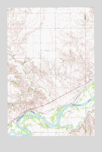
Intake, MT USGS Topographic Map
Click on map above to begin viewing in our Map Viewer.

This topographic map contains these locations and features:
Feature Name Type Latitude Longitude GNIS ID View Map
17N56E04BDC_01 WellWellN47.2611°W104.5927°821776View Map
17N56E04DC__01 WellWellN47.2553°W104.5858°821716View Map
17N56E04DC__02 WellWellN47.2553°W104.5858°821717View Map
17N56E04DC__03 WellWellN47.2553°W104.5858°821718View Map
17N56E11BBBB01 WellWellN47.2533°W104.5563°821705View Map
18N56E15BDBD01 WellWellN47.3208°W104.5702°822191View Map
18N56E24DCDD01 WellWellN47.2972°W104.5200°822038View Map
18N56E24DCDD02 WellWellN47.2972°W104.5200°822039View Map
18N56E25ADBA01 WellWellN47.2928°W104.5172°821995View Map
18N56E25ADBA02 WellWellN47.2928°W104.5172°821996View Map
18N56E25CB__01 WellWellN47.2917°W104.5269°821991View Map
18N56E25DB__01 WellWellN47.2881°W104.5222°821972View Map
18N56E26DD__01 WellWellN47.2845°W104.5380°821940View Map
18N56E26DD__02 WellWellN47.2845°W104.5380°821941View Map
18N56E29ADBA01 WellWellN47.2928°W104.6019°821997View Map
18N56E34AB__01 WellWellN47.2808°W104.5647°821911View Map
18N56E34ABDB01 WellWellN47.2795°W104.5636°821900View Map
18N56E36BB__01 WellWellN47.2808°W104.5327°821910View Map
18N57E18CBDB01 WellWellN47.3161°W104.5097°822155View Map
18N57E19CA__01 WellWellN47.3014°W104.5061°822066View Map
19N56E26CBCA01 WellWellN47.3742°W104.5544°822523View Map
Box Elder CreekStreamN47.2733°W104.5122°769154View Map
Corom CreekStreamN47.2725°W104.6241°1715476View Map
Elm CouleeValleyN47.2581°W104.5338°1715605View Map
First Congregational Church of IntakeChurchN47.2872°W104.5286°1715458View Map
Grand View CemeteryCemeteryN47.2972°W104.5383°1715461View Map
IntakeLocaleN47.2942°W104.5225°1715368View Map
IntakePopulated PlaceN47.2939°W104.5219°772708View Map
Intake Dam Fishing Access SiteLocaleN47.2803°W104.5222°1744339View Map
Intake Post Office (historical)Post OfficeN47.2942°W104.5225°1715367View Map
Intake School (historical)SchoolN47.2870°W104.5297°1715538View Map
Joes IslandIslandN47.2689°W104.5316°1715613View Map
Ladwig School (historical)SchoolN47.3478°W104.5777°1715542View Map
Linden CreekStreamN47.2936°W104.5180°773368View Map
Lower Yellowstone Diversion DamDamN47.2806°W104.5297°1715600View Map
Morgan CreekStreamN47.2617°W104.6133°774378View Map
Thirteenmile CreekStreamN47.2758°W104.5519°792073View Map

Note: Coordinates in the location and feature list above are referenced to NAD83 datum.


Copyright (C) 2008-2024 Ryan Niemi / Sunset Dynamics ... All Rights Reserved