TopoQuest Logo
Do you find TopoQuest useful?
Help keep TopoQuest running and adding new maps/features by donating!
Bitcoin:  19c7KJd3qBynnjoSw5npx9KScwjBe4ifkT
Litecoin:  LXs6TkuXGGXo1vDsWCkWVdjQX94eUKd6ui
Home View Maps Find Maps Find Places Resources & Links


Stipek, Montana Topographic Map

USGS Map Title: Stipek, MT
USGS Map MRC: 47104B6
DRG (GeoTIFF) Download: o47104b6.tif


Neighboring USGS Topographic Map Quads:


  Morgan Creek School, MT  
47104C7
 

  Kolberg Ranch, MT  
47104C6
 

  Intake, MT  
47104C5
 

  Poverty Flat East, MT  
47104B7
 

  Stipek, MT  
47104B6
 

  Belle Prairie, MT  
47104B5
 

  Forest Park, MT  
47104A7
 

  Glendive, MT  
47104A6
 

  Allard, MT  
47104A5


Map MRC Location:

N48°
W105°
N48°
W104°
H8 H7 H6 H5 H4 H3 H2 H1
G8 G7 G6 G5 G4 G3 G2 G1
F8 F7 F6 F5 F4 F3 F2 F1
E8 E7 E6 E5 E4 E3 E2 E1
D8 D7 D6 D5 D4 D3 D2 D1
C8 C7 C6 C5 C4 C3 C2 C1
B8 B7 B6 B5 B4 B3 B2 B1
A8 A7 A6 A5 A4 A3 A2 A1
N47°
W105°
N47°
W104°

Stipek, MT USGS 1:24K Topographic Map Preview:
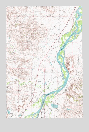
Stipek, MT USGS Topographic Map
Click on map above to begin viewing in our Map Viewer.

This topographic map contains these locations and features:
Feature Name Type Latitude Longitude GNIS ID View Map
15N55E23ACC_01 WellWellN47.1297°W104.7222°820914View Map
16N55E01DC__01 WellWellN47.1670°W104.6969°821194View Map
16N55E01DD__01 WellWellN47.1670°W104.6916°821193View Map
16N55E02DC__01 WellWellN47.1670°W104.7180°821195View Map
16N55E10BCBD01 WellWellN47.1608°W104.7450°821142View Map
16N55E12ABAA01 WellWellN47.1653°W104.7108°821178View Map
16N55E12BB__01 WellWellN47.1633°W104.7075°821156View Map
16N55E12BD__01 WellWellN47.1597°W104.7022°821127View Map
16N55E12CCBB01 WellWellN47.1547°W104.7083°821077View Map
16N55E13BD__01 WellWellN47.1453°W104.7022°821004View Map
16N55E14AD__01 WellWellN47.1453°W104.7127°821005View Map
16N55E14DADD01 WellWellN47.1408°W104.7108°820977View Map
16N55E22DDD_01 WellWellN47.1353°W104.7141°820944View Map
16N55E23AC__01 WellWellN47.1306°W104.7180°820922View Map
16N55E23CDC_01 WellWellN47.1317°W104.7088°820929View Map
16N56E06CA__01 WellWellN47.1711°W104.6805°821221View Map
16N56E06DB__01 WellWellN47.1711°W104.6752°821220View Map
16N56E07BBBC01 WellWellN47.1647°W104.6875°821173View Map
16N56E08AABD01 WellWellN47.1647°W104.6497°821172View Map
16N56E20BB__01 WellWellN47.1347°W104.6647°820941View Map
16N56E20CBAC01 WellWellN47.1281°W104.6638°820903View Map
17N55E12DADC01 WellWellN47.2431°W104.6433°821649View Map
17N55E13AA__01 WellWellN47.2378°W104.6452°821615View Map
17N55E23AB__01 WellWellN47.2231°W104.6716°821534View Map
17N55E23BC__01 WellWellN47.2195°W104.6822°821509View Map
17N55E23CDDC01 WellWellN47.2106°W104.6750°821464View Map
17N55E23DA__01 WellWellN47.2158°W104.6663°821488View Map
17N55E23DACC01 WellWellN47.2142°W104.6686°821481View Map
17N55E23DCBA01 WellWellN47.2133°W104.6716°821477View Map
17N55E23DD__01 WellWellN47.2122°W104.6663°821470View Map
17N55E26BBAC01 WellWellN47.2083°W104.6791°821444View Map
17N55E34AD__01 WellWellN47.1903°W104.6875°821321View Map
17N55E34DBDD01 WellWellN47.1847°W104.6902°821296View Map
17N55E34DD__01 WellWellN47.1831°W104.6875°821287View Map
17N55E34DD__02 WellWellN47.1831°W104.6875°821288View Map
17N55E35AB__01 WellWellN47.1939°W104.6716°821358View Map
17N56E31CC__01 WellWellN47.1833°W104.6388°821290View Map
Bryants ButtesSummitN47.1395°W104.6352°1715607View Map
Camp Canby (historical)LocaleN47.1439°W104.6869°1715386View Map
Camp Porter (historical)MilitaryN47.1508°W104.6925°1715385View Map
Cotton CreekStreamN47.1686°W104.6494°781709View Map
Cottonwood Country ClubLocaleN47.1300°W104.7447°799301View Map
Cottonwood Country Club DamDamN47.1317°W104.7455°795946View Map
Crisafulli CreekStreamN47.1278°W104.7166°1715475View Map
Crisafulli LakeReservoirN47.1322°W104.7470°770299View Map
Custers LookoutSummitN47.1695°W104.7227°770393View Map
Dawson County Correctional FacilityBuildingN47.1310°W104.6852°2548983View Map
Dawson County FairgroundsLocaleN47.1339°W104.6891°1715481View Map
Dawson County Sheriff's OfficeBuildingN47.1311°W104.6852°1715396View Map
Deer CreekStreamN47.1720°W104.6594°770584View Map
Deer Creek SchoolSchoolN47.1661°W104.6994°770586View Map
Eastern Montana Veterans HomeHospitalN47.1281°W104.6905°1715595View Map
Glendive Airport (historical)AirportN47.1278°W104.6847°1715480View Map
Glendive CampgroundLocaleN47.1256°W104.6936°1715596View Map
Glendive CreekStreamN47.1425°W104.6883°771802View Map
Glendive Police DepartmentBuildingN47.1313°W104.6852°1715397View Map
Glendive Sewage Disposal Ponds DamDamN47.1383°W104.6722°798066View Map
Guelff DamDamN47.1350°W104.6488°795939View Map
Hollecker DamDamN47.1300°W104.7272°795476View Map
Hollecker LakeReservoirN47.1282°W104.7283°795477View Map
Hollecker ParkParkN47.1292°W104.7263°1715420View Map
Hollecker Pond Fishing Access SiteLocaleN47.1264°W104.7294°1744345View Map
Lower Sevenmile CreekStreamN47.2397°W104.6358°773740View Map
Meissner American Legion Baseball FieldParkN47.1320°W104.6852°1715419View Map
Nolton Post Office (historical)Post OfficeN47.1317°W104.6866°1715356View Map
Pettersen Number 1 DamDamN47.1633°W104.6955°797831View Map
Rong School (historical)SchoolN47.2392°W104.6511°1715566View Map
Schaffer IslandIslandN47.2320°W104.6297°1715609View Map
StipekPopulated PlaceN47.2122°W104.6650°777221View Map
StipekLocaleN47.2125°W104.6644°1715525View Map
Stipek Post Office (historical)Post OfficeN47.2125°W104.6644°1715339View Map
Stipek School (historical)SchoolN47.2147°W104.6652°1715576View Map
Threemile School (historical)StreamN47.2003°W104.6755°777616View Map

Note: Coordinates in the location and feature list above are referenced to NAD83 datum.


Copyright (C) 2008-2025 Ryan Niemi / Sunset Dynamics ... All Rights Reserved