TopoQuest Logo
Do you find TopoQuest useful?
Help keep TopoQuest running and adding new maps/features by donating!
Bitcoin:  19c7KJd3qBynnjoSw5npx9KScwjBe4ifkT
Litecoin:  LXs6TkuXGGXo1vDsWCkWVdjQX94eUKd6ui
Home View Maps Find Maps Find Places Resources & Links


Iraan, Texas Topographic Map

USGS Map Title: Iraan, TX
USGS Map MRC: 30101H8
DRG (GeoTIFF) Download: o30101h8.tif


Neighboring USGS Topographic Map Quads:


  Table Top Mountain, TX  
31102A1
 

  Cedar Canyon, TX  
31101A8
 

  Rankin SE, TX  
31101A7
 

  Indian Mesa NE, TX  
30102H1
 

  Iraan, TX  
30101H8
 

  Twelvemile Camp, TX  
30101H7
 

  Indian Mesa SE, TX  
30102G1
 

  Divide Country, TX  
30101G8
 

  Deer Canyon, TX  
30101G7


Map MRC Location:

N31°
W102°
N31°
W101°
H8 H7 H6 H5 H4 H3 H2 H1
G8 G7 G6 G5 G4 G3 G2 G1
F8 F7 F6 F5 F4 F3 F2 F1
E8 E7 E6 E5 E4 E3 E2 E1
D8 D7 D6 D5 D4 D3 D2 D1
C8 C7 C6 C5 C4 C3 C2 C1
B8 B7 B6 B5 B4 B3 B2 B1
A8 A7 A6 A5 A4 A3 A2 A1
N30°
W102°
N30°
W101°

Iraan, TX USGS 1:24K Topographic Map Preview:
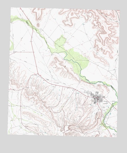
Iraan, TX USGS Topographic Map
Click on map above to begin viewing in our Map Viewer.

This topographic map contains these locations and features:
Feature Name Type Latitude Longitude GNIS ID View Map
Brave StadiumParkN30.9099°W101.8996°2028002View Map
Camp WebbLocaleN30.9102°W101.8787°1353686View Map
City of IraanCivilN30.9129°W101.9001°2410113View Map
East Prong Simpson CanyonValleyN30.9872°W101.8753°1373563View Map
IraanPopulated PlaceN30.9140°W101.8979°1360022View Map
Iraan City HallBuildingN30.9139°W101.9037°2753328View Map
Iraan City ParkParkN30.9202°W101.9085°2029160View Map
Iraan Elementary SchoolSchoolN30.9093°W101.9011°2008072View Map
Iraan General HospitalHospitalN30.9149°W101.9073°2015743View Map
Iraan High SchoolSchoolN30.9094°W101.9000°2008073View Map
Iraan Junior High SchoolSchoolN30.9093°W101.9011°2008074View Map
Iraan Municipal AirportAirportN30.9080°W101.8974°1386943View Map
Iraan Post OfficePost OfficeN30.9112°W101.8978°2731860View Map
Iraan Volunteer Fire Department and Emergency Medical ServicesBuildingN30.9138°W101.9038°2552064View Map
Memory Garden CemeteryCemeteryN30.9096°W101.8865°1362606View Map
Pecos County Constable's Office Precinct 3BuildingN30.9138°W101.9034°2750459View Map
Restland CemeteryCemeteryN30.9307°W101.9576°1366376View Map
Simpson CanyonValleyN30.9300°W101.8904°1368306View Map
T Y C Sheffield CampusSchoolN30.9093°W101.9011°2008075View Map
West Prong Simpson CanyonValleyN30.9876°W101.8761°1371203View Map
Yates Oil FieldOilfieldN30.8879°W101.9482°1372021View Map

Note: Coordinates in the location and feature list above are referenced to NAD83 datum.


Copyright (C) 2008-2025 Ryan Niemi / Sunset Dynamics ... All Rights Reserved