TopoQuest Logo
Do you find TopoQuest useful?
Help keep TopoQuest running and adding new maps/features by donating!
Bitcoin:  19c7KJd3qBynnjoSw5npx9KScwjBe4ifkT
Litecoin:  LXs6TkuXGGXo1vDsWCkWVdjQX94eUKd6ui
Home View Maps Find Maps Find Places Resources & Links


Iverson, Minnesota Topographic Map

USGS Map Title: Iverson, MN
USGS Map MRC: 46092F5
DRG (GeoTIFF) Download: o46092f5.tif


Neighboring USGS Topographic Map Quads:


  Martin Lake, MN  
46092G6
 

  Brookston, MN  
46092G5
 

  Saginaw, MN  
46092G4
 

  Sawyer, MN  
46092F6
 

  Iverson, MN  
46092F5
 

  Cloquet, MN  
46092F4
 

  Barnum, MN  
46092E6
 

  Atkinson, MN  
46092E5
 

  Wrenshall, MN  
46092E4


Map MRC Location:

N47°
W93°
N47°
W92°
H8 H7 H6 H5 H4 H3 H2 H1
G8 G7 G6 G5 G4 G3 G2 G1
F8 F7 F6 F5 F4 F3 F2 F1
E8 E7 E6 E5 E4 E3 E2 E1
D8 D7 D6 D5 D4 D3 D2 D1
C8 C7 C6 C5 C4 C3 C2 C1
B8 B7 B6 B5 B4 B3 B2 B1
A8 A7 A6 A5 A4 A3 A2 A1
N46°
W93°
N46°
W92°

Iverson, MN USGS 1:24K Topographic Map Preview:
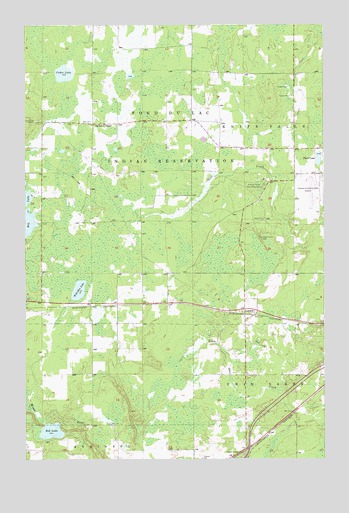
Iverson, MN USGS Topographic Map
Click on map above to begin viewing in our Map Viewer.

This topographic map contains these locations and features:
Feature Name Type Latitude Longitude GNIS ID View Map
Big Lake ChapelPopulated PlaceN46.7216°W92.5969°640101View Map
Big Lake Golf CourseLocaleN46.7208°W92.6167°2073834View Map
Bob LakeLakeN46.6332°W92.6144°640317View Map
Cedar LakeLakeN46.7362°W92.6090°641017View Map
Cloquet Carlton County AirportAirportN46.7030°W92.5041°660112View Map
Cloquet Forest Experiment StationLocaleN46.7049°W92.5227°659807View Map
Fond du Lac Ojibway SchoolSchoolN46.7133°W92.5125°2073831View Map
Fond du Lac Tribal and Community CenterBuildingN46.7139°W92.5167°2073832View Map
IversonLocaleN46.6664°W92.5292°2074108View Map
IversonPopulated PlaceN46.6663°W92.5294°645547View Map
Iverson Post OfficePost OfficeN46.6664°W92.5292°2074107View Map
Otter CreekPopulated PlaceN46.6252°W92.5388°649043View Map
Perch Lake Volunteer Fire DepartmentBuildingN46.7221°W92.5848°2666437View Map
Pine Hill Golf ClubLocaleN46.6353°W92.5167°2074249View Map
Third LakeLakeN46.7115°W92.5022°653134View Map
Township of Perch LakeCivilN46.7229°W92.6184°665282View Map
Wild Rice LakeLakeN46.6739°W92.6028°654135View Map

Note: Coordinates in the location and feature list above are referenced to NAD83 datum.


Copyright (C) 2008-2025 Ryan Niemi / Sunset Dynamics ... All Rights Reserved