TopoQuest Logo
Do you find TopoQuest useful?
Help keep TopoQuest running and adding new maps/features by donating!
Bitcoin:  19c7KJd3qBynnjoSw5npx9KScwjBe4ifkT
Litecoin:  LXs6TkuXGGXo1vDsWCkWVdjQX94eUKd6ui
Home View Maps Find Maps Find Places Resources & Links


Jacob Spring, New Mexico Topographic Map

USGS Map Title: Jacob Spring, NM
USGS Map MRC: 33105F5
DRG (GeoTIFF) Download: o33105f5.tif


Neighboring USGS Topographic Map Quads:


  White Oaks North, NM  
33105G6
 

  Jicarilla Peak, NM  
33105G5
 

  Box Lake, NM  
33105G4
 

  White Oaks South, NM  
33105F6
 

  Jacob Spring, NM  
33105F5
 

  Encinoso, NM  
33105F4
 

  Nogal, NM  
33105E6
 

  Capitan, NM  
33105E5
 

  Capitan Pass, NM  
33105E4


Map MRC Location:

N34°
W106°
N34°
W105°
H8 H7 H6 H5 H4 H3 H2 H1
G8 G7 G6 G5 G4 G3 G2 G1
F8 F7 F6 F5 F4 F3 F2 F1
E8 E7 E6 E5 E4 E3 E2 E1
D8 D7 D6 D5 D4 D3 D2 D1
C8 C7 C6 C5 C4 C3 C2 C1
B8 B7 B6 B5 B4 B3 B2 B1
A8 A7 A6 A5 A4 A3 A2 A1
N33°
W106°
N33°
W105°

Jacob Spring, NM USGS 1:24K Topographic Map Preview:
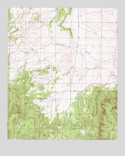
Jacob Spring, NM USGS Topographic Map
Click on map above to begin viewing in our Map Viewer.

This topographic map contains these locations and features:
Feature Name Type Latitude Longitude GNIS ID View Map
Aragon CreekStreamN33.6987°W105.5178°903254View Map
Bear TankReservoirN33.6386°W105.6086°903683View Map
Big BenMineN33.6601°W105.5150°916936View Map
Blanchard CanyonValleyN33.7126°W105.5561°903913View Map
Blind TankReservoirN33.6343°W105.5072°903923View Map
Broken ToeMineN33.6601°W105.5816°916941View Map
Dark CanyonValleyN33.6756°W105.6230°905596View Map
Dogtown TankReservoirN33.6301°W105.5348°905806View Map
East Carrizo ConeSummitN33.6504°W105.6147°905956View Map
Encinoso CemeteryCemeteryN33.6862°W105.5041°906173View Map
Give-A-Damn CanyonValleyN33.6873°W105.5078°906557View Map
Give-A-Damn WellWellN33.6592°W105.5230°906558View Map
Iron Mine TankReservoirN33.6280°W105.5572°907254View Map
Jacob SpringSpringN33.6466°W105.5301°907297View Map
Jacob TankReservoirN33.6560°W105.5347°907298View Map
Lacey RanchLocaleN33.6612°W105.5861°907735View Map
LeslieLocaleN33.6901°W105.6133°929540View Map
Leslie RanchLocaleN33.6806°W105.6217°1985275View Map
McCrory Prospect Sec 31MineN33.6573°W105.5108°915324View Map
McCrory Prospect Sec 36MineN33.6545°W105.5255°915325View Map
Middle TankReservoirN33.6633°W105.6060°908716View Map
Northeast TankReservoirN33.6292°W105.5853°909210View Map
Northeast TankReservoirN33.6448°W105.5482°909211View Map
Read MesaSummitN33.6345°W105.5930°910033View Map
Section Thirty TankReservoirN33.6653°W105.6177°910912View Map
South Fork Aragon CreekStreamN33.6926°W105.5319°1986850View Map
Southeast TankReservoirN33.6313°W105.5751°911286View Map
Ten Dollar TankReservoirN33.6375°W105.5646°911602View Map
Texas ParkAreaN33.7081°W105.6144°911621View Map
Weddige RanchLocaleN33.6656°W105.5461°912201View Map
WhettigeMineN33.6604°W105.5500°914772View Map

Note: Coordinates in the location and feature list above are referenced to NAD83 datum.


Copyright (C) 2008-2025 Ryan Niemi / Sunset Dynamics ... All Rights Reserved