TopoQuest Logo
Do you find TopoQuest useful?
Help keep TopoQuest running and adding new maps/features by donating!
Bitcoin:  19c7KJd3qBynnjoSw5npx9KScwjBe4ifkT
Litecoin:  LXs6TkuXGGXo1vDsWCkWVdjQX94eUKd6ui
Home View Maps Find Maps Find Places Resources & Links


Capitan, New Mexico Topographic Map

USGS Map Title: Capitan, NM
USGS Map MRC: 33105E5
DRG (GeoTIFF) Download: o33105e5.tif


Neighboring USGS Topographic Map Quads:


  White Oaks South, NM  
33105F6
 

  Jacob Spring, NM  
33105F5
 

  Encinoso, NM  
33105F4
 

  Nogal, NM  
33105E6
 

  Capitan, NM  
33105E5
 

  Capitan Pass, NM  
33105E4
 

  Angus, NM  
33105D6
 

  Fort Stanton, NM  
33105D5
 

  Lincoln, NM  
33105D4


Map MRC Location:

N34°
W106°
N34°
W105°
H8 H7 H6 H5 H4 H3 H2 H1
G8 G7 G6 G5 G4 G3 G2 G1
F8 F7 F6 F5 F4 F3 F2 F1
E8 E7 E6 E5 E4 E3 E2 E1
D8 D7 D6 D5 D4 D3 D2 D1
C8 C7 C6 C5 C4 C3 C2 C1
B8 B7 B6 B5 B4 B3 B2 B1
A8 A7 A6 A5 A4 A3 A2 A1
N33°
W106°
N33°
W105°

Capitan, NM USGS 1:24K Topographic Map Preview:
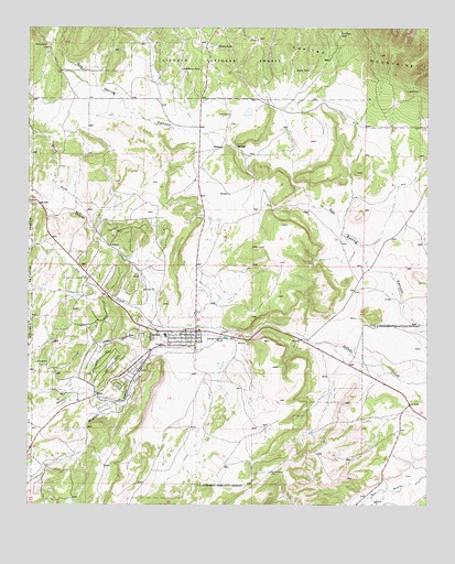
Capitan, NM USGS Topographic Map
Click on map above to begin viewing in our Map Viewer.

This topographic map contains these locations and features:
Feature Name Type Latitude Longitude GNIS ID View Map
10010 Water WellWellN33.5448°W105.5703°931738View Map
CapitanPopulated PlaceN33.5454°W105.5722°923574View Map
Capitan Elementary SchoolSchoolN33.5445°W105.5825°934032View Map
Capitan Forest Service FacilityLocaleN33.5423°W105.5822°912652View Map
Capitan Four Square ChurchChurchN33.5454°W105.5722°901926View Map
Capitan High SchoolSchoolN33.5445°W105.5825°934033View Map
Capitan Historical MarkerParkN33.5454°W105.5722°932253View Map
Capitan MineMineN33.6223°W105.5572°916944View Map
Capitan Number OneMineN33.5598°W105.5941°916945View Map
Capitan Number TwoMineN33.5540°W105.5933°916946View Map
Capitan Police DepartmentBuildingN33.5450°W105.5732°2722504View Map
Capitan Post OfficePost OfficeN33.5459°W105.5756°938132View Map
Capitan Volunteer Fire Department Station 1 HeadquartersBuildingN33.5453°W105.5705°2657928View Map
Capitan Volunteer Fire Department Station 2BuildingN33.5330°W105.6138°2657947View Map
Capitan Weather StationLocaleN33.5454°W105.5722°931829View Map
Capitian Depot Historic SiteBuildingN33.5454°W105.5722°935185View Map
Christ Community Fellowship ChurchChurchN33.5454°W105.5722°901927View Map
Church of ChristChurchN33.5454°W105.5722°902428View Map
CoaloraPopulated PlaceN33.5679°W105.5972°905225View Map
Coalora Post Office (historical)Post OfficeN33.5679°W105.5972°937976View Map
Flatley RanchLocaleN33.6204°W105.6197°906302View Map
Fort StantonParkN33.5026°W105.5136°1985277View Map
Golder RanchLocaleN33.6020°W105.5625°911723View Map
GrayMineN33.5429°W105.6155°915298View Map
Hondo TankReservoirN33.6200°W105.5665°907062View Map
Lincoln County Emergency Medical Services Capitan StationBuildingN33.5453°W105.5707°2657594View Map
LindermanMineN33.5392°W105.6200°914800View Map
Los Patos RuinsLocaleN33.5454°W105.5722°936057View Map
Magado CreekStreamN33.5459°W105.5628°908352View Map
Marfield WellWellN33.5423°W105.6247°912651View Map
North Fork Salado CreekStreamN33.5729°W105.6050°909153View Map
Oso CreekStreamN33.5465°W105.5830°909389View Map
Robinson RanchLocaleN33.5698°W105.6205°912650View Map
Sacred Heart Catholic ChurchChurchN33.5454°W105.5722°902045View Map
Smokey Bear State Park Point of InterestLocaleN33.5498°W105.5750°924219View Map
Smokey MineMineN33.6223°W105.5572°916987View Map
South Fork Salado CreekStreamN33.5790°W105.6211°911252View Map
South TankReservoirN33.6141°W105.5376°911277View Map
Southwest TankReservoirN33.6139°W105.5777°911289View Map
Tie Chute TankReservoirN33.6235°W105.5281°911696View Map
Trinity Southern Baptist ChurchChurchN33.5454°W105.5722°901802View Map
United Methodist Church ParishChurchN33.5454°W105.5722°901823View Map
Village of CapitanCivilN33.5392°W105.5982°2413537View Map

Note: Coordinates in the location and feature list above are referenced to NAD83 datum.


Copyright (C) 2008-2025 Ryan Niemi / Sunset Dynamics ... All Rights Reserved