TopoQuest Logo
Do you find TopoQuest useful?
Help keep TopoQuest running and adding new maps/features by donating!
Bitcoin:  19c7KJd3qBynnjoSw5npx9KScwjBe4ifkT
Litecoin:  LXs6TkuXGGXo1vDsWCkWVdjQX94eUKd6ui
Home View Maps Find Maps Find Places Resources & Links


Baldwin Gap, North Carolina Topographic Map

USGS Map Title: Baldwin Gap, NC
USGS Map MRC: 36081D6
DRG (GeoTIFF) Download: o36081d6.tif


Neighboring USGS Topographic Map Quads:


  Laurel Bloomery, TN  
36081E7
 

  Grayson, NC  
36081E6
 

  Park, NC  
36081E5
 

  Mountain City, TN  
36081D7
 

  Baldwin Gap, NC  
36081D6
 

  Warrensville, NC  
36081D5
 

  Sherwood, NC  
36081C7
 

  Zionville, TN  
36081C6
 

  Todd, NC  
36081C5


Map MRC Location:

N37°
W82°
N37°
W81°
H8 H7 H6 H5 H4 H3 H2 H1
G8 G7 G6 G5 G4 G3 G2 G1
F8 F7 F6 F5 F4 F3 F2 F1
E8 E7 E6 E5 E4 E3 E2 E1
D8 D7 D6 D5 D4 D3 D2 D1
C8 C7 C6 C5 C4 C3 C2 C1
B8 B7 B6 B5 B4 B3 B2 B1
A8 A7 A6 A5 A4 A3 A2 A1
N36°
W82°
N36°
W81°

Baldwin Gap, NC USGS 1:24K Topographic Map Preview:
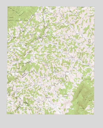
Baldwin Gap, NC USGS Topographic Map
Click on map above to begin viewing in our Map Viewer.

This topographic map contains these locations and features:
Feature Name Type Latitude Longitude GNIS ID View Map
Allen CemeteryCemeteryN36.4387°W81.6618°980101View Map
Amber GapGapN36.4532°W81.7151°1275653View Map
AshlandPopulated PlaceN36.4410°W81.6596°1018866View Map
Baldwin GapGapN36.4235°W81.7198°980485View Map
Baptist Home ChurchChurchN36.4568°W81.6843°980535View Map
Bearlog HollowValleyN36.4249°W81.7495°1276652View Map
Big BranchStreamN36.4671°W81.6423°981353View Map
Big KnobSummitN36.3912°W81.6276°1019148View Map
Big Laurel ChurchChurchN36.4690°W81.6415°981418View Map
Big Laurel ChurchChurchN36.4829°W81.6665°981419View Map
Brown CemeteryCemeteryN36.4640°W81.7454°1278564View Map
Brown CemeteryCemeteryN36.4334°W81.6590°982007View Map
Brown CemeteryCemeteryN36.4576°W81.7021°982008View Map
Brush ForkStreamN36.4082°W81.6846°982057View Map
Buck KnobSummitN36.3751°W81.7457°1278827View Map
Cabbage CreekStreamN36.4390°W81.6562°982378View Map
Catface MountainSummitN36.4740°W81.6948°1019562View Map
Commissioner District 2CivilN36.4747°W81.7437°2463939View Map
Cornett CemeteryCemeteryN36.4037°W81.6879°983577View Map
Curd School (historical)SchoolN36.4729°W81.7232°1307445View Map
Cut Laurel CreekStreamN36.4973°W81.6884°1010626View Map
Dowell (historical)Populated PlaceN36.4765°W81.7171°1307452View Map
Dowell CemeteryCemeteryN36.4307°W81.7446°1282761View Map
Dunn CemeteryCemeteryN36.4673°W81.7354°1283203View Map
Dunn HollowValleyN36.4658°W81.7333°1283211View Map
East Fork Roaring ForkStreamN36.4893°W81.6507°1010994View Map
Eastridge CemeteryCemeteryN36.4662°W81.6762°984566View Map
Fall BranchStreamN36.4260°W81.7498°1328171View Map
Farmer CemeteryCemeteryN36.4498°W81.6723°985006View Map
Forge SchoolSchoolN36.4604°W81.7473°1284615View Map
Forrester CemeteryCemeteryN36.4529°W81.7243°1284654View Map
Fox HollowValleyN36.4307°W81.7421°1307459View Map
Graybeal (historical)Populated PlaceN36.4690°W81.6482°1004526View Map
Graybeal BranchStreamN36.4448°W81.6621°985990View Map
Graybeal CemeteryCemeteryN36.4287°W81.6537°985991View Map
Graybeal CemeteryCemeteryN36.4704°W81.6482°985992View Map
Green ValleyPopulated PlaceN36.4087°W81.7034°1020550View Map
Green Valley CemeteryCemeteryN36.4123°W81.7015°986089View Map
Greer CemeteryCemeteryN36.4079°W81.7454°1286219View Map
Greer HollowValleyN36.3980°W81.7491°1286223View Map
Greer MountainSummitN36.4090°W81.7493°1328336View Map
Ham CemeteryCemeteryN36.4929°W81.6954°986330View Map
Hammon CemeteryCemeteryN36.4757°W81.7290°1286681View Map
Hammon ChapelChurchN36.4718°W81.7290°1286682View Map
Hampton CemeteryCemeteryN36.4248°W81.7404°1286700View Map
Hampton CemeteryCemeteryN36.4396°W81.7157°1286701View Map
Hampton RidgeRidgeN36.4290°W81.7298°1286707View Map
HemlockLocaleN36.4985°W81.6887°1023502View Map
Hoskin ForkStreamN36.3943°W81.6915°987158View Map
Humphrey CemeteryCemeteryN36.4459°W81.6640°987241View Map
Jenkins CemeteryCemeteryN36.3979°W81.6784°987551View Map
Johnson CemeteryCemeteryN36.4412°W81.6484°987664View Map
Jones CemeteryCemeteryN36.4393°W81.7148°987728View Map
Jones HollowValleyN36.4226°W81.7398°1289808View Map
Knight CemeteryCemeteryN36.4082°W81.7132°988041View Map
Laurel Hill ChurchChurchN36.4818°W81.6565°988200View Map
Laurel Springs ChurchChurchN36.4898°W81.7029°1290763View Map
Laurel Springs School (historical)SchoolN36.4915°W81.7015°1307470View Map
Leander MountainSummitN36.4448°W81.7212°1290872View Map
Lewis CemeteryCemeteryN36.4482°W81.6709°988386View Map
Lewis CemeteryCemeteryN36.4576°W81.6998°988387View Map
Lihue KnobSummitN36.4623°W81.6715°1021147View Map
Little Laurel ChurchChurchN36.4623°W81.6557°988694View Map
Little Laurel CreekStreamN36.4560°W81.6282°988696View Map
Long Hope FallsFallsN36.3821°W81.6390°988973View Map
Martin ChapelChurchN36.4057°W81.7248°989397View Map
MaxwellLocaleN36.4073°W81.6807°1023503View Map
Maxwell CemeteryCemeteryN36.4112°W81.6690°989491View Map
McEwen CemeteryCemeteryN36.4526°W81.7440°1293275View Map
Mock CemeteryCemeteryN36.4526°W81.6332°990120View Map
Monkey BranchStreamN36.4229°W81.6829°990141View Map
Mountain View ChurchChurchN36.4171°W81.6959°990728View Map
Nelson CemeteryCemeteryN36.4576°W81.6496°990908View Map
Oliver CemeteryCemeteryN36.4576°W81.6254°991646View Map
OsbornPopulated PlaceN36.4548°W81.7257°1307481View Map
Osborne CemeteryCemeteryN36.4565°W81.6826°991703View Map
Osborne CemeteryCemeteryN36.4701°W81.6940°991704View Map
ParkerPopulated PlaceN36.4579°W81.6893°1021806View Map
Parmer CemeteryCemeteryN36.4809°W81.6643°991887View Map
Payne BranchStreamN36.4729°W81.7237°1297003View Map
Payne CemeteryCemeteryN36.4718°W81.7201°1297008View Map
Payne CemeteryCemeteryN36.4929°W81.6982°1297009View Map
Payne GapGapN36.4918°W81.6954°1000708View Map
Payne HollowValleyN36.4637°W81.7442°1329104View Map
Peak CoveValleyN36.4125°W81.6673°991983View Map
Peak ValleyValleyN36.4068°W81.6821°991986View Map
Peak Valley ChurchChurchN36.3957°W81.6698°991987View Map
Peak View ChurchChurchN36.3985°W81.6634°991988View Map
Pennington CemeteryCemeteryN36.4576°W81.6440°992034View Map
Pine MountainSummitN36.4337°W81.7212°1297567View Map
Pine Mountain BranchStreamN36.4160°W81.6984°992273View Map
Pine Mountain ChurchChurchN36.4412°W81.7129°992276View Map
Pleasant Hill ChurchChurchN36.4679°W81.6954°1297885View Map
Pleasant Hill ChurchChurchN36.4676°W81.6951°992543View Map
Pond MountainSummitN36.4923°W81.6812°1022026View Map
Potter CemeteryCemeteryN36.3832°W81.7043°992749View Map
Potter CemeteryCemeteryN36.3937°W81.7007°992750View Map
Price CemeteryCemeteryN36.4201°W81.6801°992807View Map
Price HollowValleyN36.4225°W81.7497°1298515View Map
Prosperity ChurchChurchN36.4037°W81.7346°992859View Map
Roaring ForkStreamN36.4796°W81.6601°1014945View Map
Roaring Fork ChurchChurchN36.4798°W81.6593°993431View Map
Roark CemeteryCemeteryN36.4015°W81.6548°993437View Map
Roark CemeteryCemeteryN36.4443°W81.6979°993438View Map
Rock CreekStreamN36.4207°W81.6654°1000713View Map
Rock Creek Baptist ChurchChurchN36.4323°W81.6918°993496View Map
Rock Creek Methodist ChurchChurchN36.4235°W81.6823°993501View Map
Roundabout ChurchChurchN36.4507°W81.6765°993759View Map
Roundabout CreekStreamN36.4412°W81.6598°993760View Map
Simcox BranchStreamN36.4710°W81.7301°1270287View Map
Smith CemeteryCemeteryN36.4362°W81.7368°1270644View Map
Snyder BranchStreamN36.4235°W81.7496°1307490View Map
Snyder CemeteryCemeteryN36.3912°W81.7468°1270793View Map
Snyder CemeteryCemeteryN36.4004°W81.7379°995080View Map
Snyder Chapel (historical)ChurchN36.4218°W81.7490°1307491View Map
Snyder GapGapN36.4012°W81.7373°995082View Map
Soup Bean BranchStreamN36.4804°W81.6668°995122View Map
Stout BranchStreamN36.4251°W81.7462°1271536View Map
SutherlandPopulated PlaceN36.3943°W81.6918°1006385View Map
Sutherland CemeteryCemeteryN36.3821°W81.6834°995722View Map
Sutherland CemeteryCemeteryN36.4240°W81.6657°995723View Map
Swift BranchStreamN36.4918°W81.6746°1015995View Map
The PeakSummitN36.4032°W81.6434°1022926View Map
Thomas CemeteryCemeteryN36.3757°W81.7068°996030View Map
Three Forks ChurchChurchN36.4410°W81.6607°996078View Map
Township of LaurelCivilN36.4794°W81.6586°1026388View Map
Township of North ForkCivilN36.4142°W81.6849°1026389View Map
Wallace BranchStreamN36.3851°W81.7043°996714View Map
Wallace CemeteryCemeteryN36.3893°W81.7440°1273677View Map
Wallace CemeteryCemeteryN36.3857°W81.7290°996718View Map
Ward CemeteryCemeteryN36.4048°W81.6984°996775View Map
Willen GapGapN36.4654°W81.6973°997348View Map
Willen GapPopulated PlaceN36.4673°W81.7054°1307506View Map
Willen MountainSummitN36.4562°W81.7165°1023257View Map
Willen MountainSummitN36.4623°W81.7079°1274615View Map
Wilson BranchStreamN36.3898°W81.7043°997433View Map
Wilson CemeteryCemeteryN36.3923°W81.7082°997439View Map
Wilson MountainSummitN36.3982°W81.7296°1023274View Map
Winebarger CemeteryCemeteryN36.3976°W81.6629°997484View Map
Woodard CemeteryCemeteryN36.4490°W81.6693°997573View Map
Woodward BranchStreamN36.4721°W81.7279°1275102View Map

Note: Coordinates in the location and feature list above are referenced to NAD83 datum.


Copyright (C) 2008-2024 Ryan Niemi / Sunset Dynamics ... All Rights Reserved