TopoQuest Logo
Do you find TopoQuest useful?
Help keep TopoQuest running and adding new maps/features by donating!
Bitcoin:  19c7KJd3qBynnjoSw5npx9KScwjBe4ifkT
Litecoin:  LXs6TkuXGGXo1vDsWCkWVdjQX94eUKd6ui
Home View Maps Find Maps Find Places Resources & Links


Jarbidge South, Nevada Topographic Map

USGS Map Title: Jarbidge South, NV
USGS Map MRC: 41115G4
DRG (GeoTIFF) Download: o41115g4.tif


Neighboring USGS Topographic Map Quads:


  Bearpaw Mountain, NV  
41115H5
 

  Jarbidge North, NV  
41115H4
 

  Robinson Creek, NV  
41115H3
 

  Coon Creek, NV  
41115G5
 

  Jarbidge South, NV  
41115G4
 

  Gods Pocket Peak, NV  
41115G3
 

  Annie Creek, NV  
41115F5
 

  Marys River Basin NW, NV  
41115F4
 

  Marys River Basin NE, NV  
41115F3


Map MRC Location:

N42°
W116°
N42°
W115°
H8 H7 H6 H5 H4 H3 H2 H1
G8 G7 G6 G5 G4 G3 G2 G1
F8 F7 F6 F5 F4 F3 F2 F1
E8 E7 E6 E5 E4 E3 E2 E1
D8 D7 D6 D5 D4 D3 D2 D1
C8 C7 C6 C5 C4 C3 C2 C1
B8 B7 B6 B5 B4 B3 B2 B1
A8 A7 A6 A5 A4 A3 A2 A1
N41°
W116°
N41°
W115°

Jarbidge South, NV USGS 1:24K Topographic Map Preview:
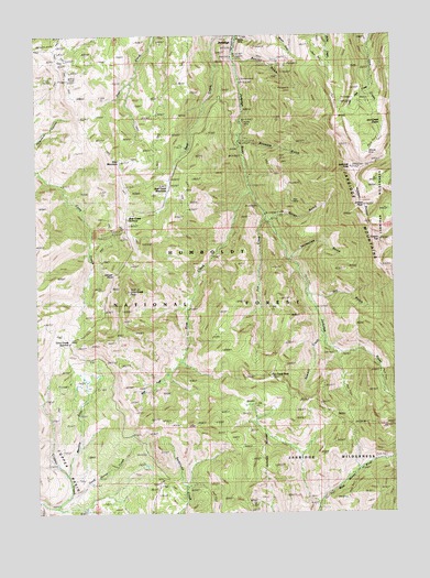
Jarbidge South, NV USGS Topographic Map
Click on map above to begin viewing in our Map Viewer.

This topographic map contains these locations and features:
Feature Name Type Latitude Longitude GNIS ID View Map
Alpha MineMineN41.8660°W115.4292°854318View Map
Altitude MineMineN41.8435°W115.3865°858692View Map
Arizona MineMineN41.8527°W115.4228°853122View Map
Arkansas MineMineN41.8291°W115.3809°853154View Map
Bald PeakSummitN41.8455°W115.3917°853142View Map
Batholith MinesMineN41.7832°W115.4940°848016View Map
Bear CreekStreamN41.8741°W115.4340°858842View Map
Bear Creek ButteSummitN41.8205°W115.4634°858457View Map
Bear Creek MeadowsFlatN41.8319°W115.4626°858844View Map
Bear Creek SummitSummitN41.8266°W115.4698°858845View Map
Ben Hur MineMineN41.8460°W115.3981°853125View Map
Black Cat MineMineN41.8266°W115.4190°853127View Map
Bluster MineMineN41.8391°W115.4151°858967View Map
Bluster National Forest CampgroundLocaleN41.8416°W115.4281°862332View Map
Bonanza CreekStreamN41.8485°W115.4292°862669View Map
Bonanza GulchValleyN41.8477°W115.4298°858972View Map
Bourne Discovery MineMineN41.8691°W115.4209°853147View Map
Bourne GulchValleyN41.8685°W115.4320°858985View Map
Buster MineMineN41.8619°W115.4253°853157View Map
Camp Draw TrailheadLocaleN41.7557°W115.4412°862329View Map
Coeur Dalene Jarbidge CabinsLocaleN41.8563°W115.3812°853143View Map
Coon Creek MineMineN41.8219°W115.4737°848017View Map
Coon Creek PeakSummitN41.8080°W115.4690°859325View Map
Coon Creek SummitGapN41.7949°W115.4887°859324View Map
Copper BasinBasinN41.7707°W115.4901°859331View Map
Cora LakeLakeN41.8366°W115.3806°858458View Map
Danger PointCliffN41.8119°W115.4740°859447View Map
Dead Horse CreekStreamN41.7541°W115.4898°859466View Map
Deer MountainSummitN41.8421°W115.4712°859500View Map
Dry GulchValleyN41.8066°W115.4062°859584View Map
Elcora MineMineN41.8741°W115.4292°862350View Map
Flaxie MineMineN41.8694°W115.4120°853160View Map
Fox CreekStreamN41.8269°W115.4212°859754View Map
Fox Creek PeakSummitN41.7852°W115.4195°859755View Map
Gold Creek TrailTrailN41.8594°W115.4723°859835View Map
Gold Spring MineMineN41.8582°W115.4212°853118View Map
Golden Stairs Number Two MineMineN41.8166°W115.3823°853151View Map
Good Luck MineMineN41.8227°W115.4173°853129View Map
Gorge GulchValleyN41.8260°W115.4198°859860View Map
Heckla MineMineN41.8338°W115.4228°853126View Map
Jack Creek CraterCraterN41.8510°W115.3815°860161View Map
JarbidgePopulated PlaceN41.8735°W115.4320°860185View Map
Jarbidge MineMineN41.8688°W115.4123°855530View Map
Jarbidge Mining DistrictCivilN41.8535°W115.4081°854319View Map
Jarbidge MountainsRangeN41.8480°W115.4006°860186View Map
Jarbidge National Forest CampgroundLocaleN41.8632°W115.4292°862334View Map
Jarbidge PeakSummitN41.8405°W115.3917°860187View Map
Jarbidge Post OfficePost OfficeN41.8735°W115.4320°864960View Map
Jarbidge Wonders MineMineN41.8216°W115.4120°853130View Map
Josephine MineMineN41.8332°W115.4120°853132View Map
Jumbo PeakSummitN41.8302°W115.3870°860234View Map
Labelle MineMineN41.8463°W115.4081°853124View Map
Legitimate MineMineN41.8694°W115.4123°855528View Map
Little Jack CreekStreamN41.8607°W115.3851°860282View Map
Little Jack Creek CraterCraterN41.8507°W115.3934°853140View Map
Long Hike MineMineN41.8738°W115.4478°855527View Map
MatterhornSummitN41.8107°W115.3753°860500View Map
Meadow ForkStreamN41.7596°W115.4909°860544View Map
Mission Cross MineMineN41.7824°W115.4909°862668View Map
Myrtle MineMineN41.8255°W115.4134°853131View Map
North HillSummitN41.8660°W115.3903°853144View Map
North Star Mill (historical)LocaleN41.8652°W115.4301°853159View Map
North Star MineMineN41.8680°W115.4273°853155View Map
O K MineMineN41.8635°W115.4145°855526View Map
Pavalak National Forest CampgroundLocaleN41.8469°W115.4292°862333View Map
Pavlak (historical)Populated PlaceN41.8482°W115.4298°862755View Map
Pavlak Mill (historical)LocaleN41.8524°W115.4287°853156View Map
Pavlak Post Office (historical)Post OfficeN41.8482°W115.4298°864262View Map
Pavlok MineMineN41.8521°W115.4278°862349View Map
Perkins CabinLocaleN41.7910°W115.3948°860917View Map
Pick and Shovel MineMineN41.8369°W115.4123°853148View Map
Pine Creek National Forest CampgroundLocaleN41.8357°W115.4262°862331View Map
Puritan MineMineN41.8485°W115.3801°853139View Map
Quartzite MineMineN41.8574°W115.4245°853119View Map
Rabbit Foot MineMineN41.8355°W115.3823°853134View Map
Rainbow American MinesMineN41.8613°W115.4284°853158View Map
Redbird MineMineN41.8541°W115.4251°853121View Map
Reliance Number One MineMineN41.8682°W115.4181°853146View Map
Rex MineMineN41.8313°W115.4115°861106View Map
Rose Bud MineMineN41.8327°W115.3781°853133View Map
Saint Joe MineMineN41.8194°W115.4131°853128View Map
Sawmill CreekStreamN41.7938°W115.4006°861274View Map
Snowslide GulchValleyN41.8163°W115.4120°861444View Map
Snowslide TrailheadLocaleN41.8163°W115.4120°862330View Map
Square TopSummitN41.8202°W115.3815°861555View Map
Starlight MineMineN41.8682°W115.4120°855529View Map
Stray Dog MineMineN41.8557°W115.4181°853120View Map
Success MineMineN41.8424°W115.4156°861615View Map
Sugar MineMineN41.8191°W115.3848°853149View Map
Sugar Number One MineMineN41.8166°W115.3837°853150View Map
Taft MineMineN41.8519°W115.4231°853123View Map
The Twins CabinLocaleN41.8688°W115.3981°853145View Map
Third Peak Number One MineMineN41.8238°W115.3870°853136View Map
Third Peak Number Two MineMineN41.8227°W115.3859°853152View Map
True Fissure CabinLocaleN41.8266°W115.3765°853153View Map
Victorias MineMineN41.8513°W115.3828°853138View Map
Vukovich CabinLocaleN41.8532°W115.3915°853141View Map
West Fork Pine CreekStreamN41.8335°W115.4259°861945View Map
White Rock MineMineN41.8416°W115.3809°853135View Map
Windy MineMineN41.8449°W115.3806°853137View Map

Note: Coordinates in the location and feature list above are referenced to NAD83 datum.


Copyright (C) 2008-2025 Ryan Niemi / Sunset Dynamics ... All Rights Reserved