TopoQuest Logo
Do you find TopoQuest useful?
Help keep TopoQuest running and adding new maps/features by donating!
Bitcoin:  19c7KJd3qBynnjoSw5npx9KScwjBe4ifkT
Litecoin:  LXs6TkuXGGXo1vDsWCkWVdjQX94eUKd6ui
Home View Maps Find Maps Find Places Resources & Links


Jared, Washington Topographic Map

USGS Map Title: Jared, WA
USGS Map MRC: 48117D3
DRG (GeoTIFF) Download: o48117d3.tif


Neighboring USGS Topographic Map Quads:


  Timber Mountain, WA  
48117E4
 

  Ruby, WA  
48117E3
 

  North Baldy, WA  
48117E2
 

  Tacoma Peak, WA  
48117D4
 

  Jared, WA  
48117D3
 

  Browns Lake, WA  
48117D2
 

  Winchester Peak, WA  
48117C4
 

  Cusick, WA  
48117C3
 

  Skookum Creek, WA  
48117C2


Map MRC Location:

N49°
W118°
N49°
W117°
H8 H7 H6 H5 H4 H3 H2 H1
G8 G7 G6 G5 G4 G3 G2 G1
F8 F7 F6 F5 F4 F3 F2 F1
E8 E7 E6 E5 E4 E3 E2 E1
D8 D7 D6 D5 D4 D3 D2 D1
C8 C7 C6 C5 C4 C3 C2 C1
B8 B7 B6 B5 B4 B3 B2 B1
A8 A7 A6 A5 A4 A3 A2 A1
N48°
W118°
N48°
W117°

Jared, WA USGS 1:24K Topographic Map Preview:
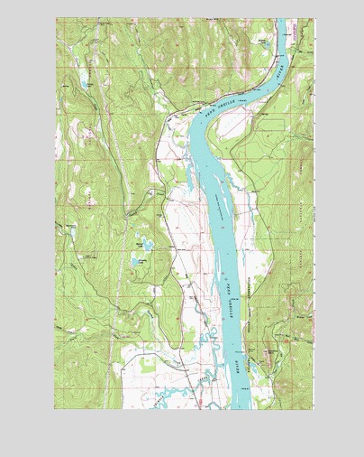
Jared, WA USGS Topographic Map
Click on map above to begin viewing in our Map Viewer.

This topographic map contains these locations and features:
Feature Name Type Latitude Longitude GNIS ID View Map
Babbitz LakeLakeN48.4913°W117.2733°1516010View Map
Babbitz LandingLocaleN48.4852°W117.2680°1530041View Map
Brownie LakeLakeN48.4222°W117.3367°1516989View Map
Browns CreekStreamN48.4046°W117.2597°1516991View Map
CecilLocaleN48.4602°W117.3258°1534070View Map
CecilLocaleN48.4602°W117.3258°1530387View Map
Cee Cee Ah CreekStreamN48.3913°W117.2838°1517583View Map
Cusick CreekStreamN48.4455°W117.3138°1518434View Map
Farm Service Agency Interest of WashingtonParkN48.3856°W117.3211°2765297View Map
Gardiner CreekStreamN48.4560°W117.3099°1519893View Map
Gibraltar RockSummitN48.3935°W117.2727°1519943View Map
Half Moon CreekStreamN48.3960°W117.2666°1520454View Map
Heater PondReservoirN48.4411°W117.2817°1532883View Map
Heater Pond DamDamN48.4432°W117.2827°1532882View Map
JaredPopulated PlaceN48.4691°W117.3155°1521330View Map
Lake LucerneLakeN48.4280°W117.3144°1522560View Map
LockePopulated PlaceN48.4266°W117.3177°1522340View Map
Locke DamDamN48.4266°W117.3261°1531962View Map
Loop CreekStreamN48.4727°W117.2616°1522450View Map
Metcalf LakeLakeN48.4274°W117.3308°1523025View Map
Mill CreekStreamN48.4899°W117.2647°1523157View Map
North Fork South Fork Tacoma CreekStreamN48.3991°W117.3622°1523849View Map
Parker LakeSwampN48.4796°W117.3611°1524216View Map
Pend Oreille Fire District 5BuildingN48.4875°W117.2704°2643699View Map
River Bend AirportAirportN48.4696°W117.2900°1533926View Map
Riverside CampLocaleN48.4724°W117.3041°1525073View Map
Ruby MountainSummitN48.4999°W117.2988°1525280View Map
Silver King MineMineN48.4980°W117.3544°1525777View Map
South Fork Tacoma CreekStreamN48.3938°W117.3236°1526263View Map
Sportsman PondLakeN48.4313°W117.3662°1526388View Map
Sullivan PointCapeN48.4135°W117.2977°1530386View Map
Tacoma CreekStreamN48.3894°W117.2972°1526891View Map
Tacoma Sportsman Pond DamDamN48.4299°W117.3677°1532366View Map
Trimble CreekStreamN48.3899°W117.2927°1527373View Map

Note: Coordinates in the location and feature list above are referenced to NAD83 datum.


Copyright (C) 2008-2024 Ryan Niemi / Sunset Dynamics ... All Rights Reserved