TopoQuest Logo
Do you find TopoQuest useful?
Help keep TopoQuest running and adding new maps/features by donating!
Bitcoin:  19c7KJd3qBynnjoSw5npx9KScwjBe4ifkT
Litecoin:  LXs6TkuXGGXo1vDsWCkWVdjQX94eUKd6ui
Home View Maps Find Maps Find Places Resources & Links


Cusick, Washington Topographic Map

USGS Map Title: Cusick, WA
USGS Map MRC: 48117C3
DRG (GeoTIFF) Download: o48117c3.tif


Neighboring USGS Topographic Map Quads:


  Tacoma Peak, WA  
48117D4
 

  Jared, WA  
48117D3
 

  Browns Lake, WA  
48117D2
 

  Winchester Peak, WA  
48117C4
 

  Cusick, WA  
48117C3
 

  Skookum Creek, WA  
48117C2
 

  Boyer Mountain, WA  
48117B4
 

  Sacheen Lake, WA  
48117B3
 

  Diamond Lake, WA  
48117B2


Map MRC Location:

N49°
W118°
N49°
W117°
H8 H7 H6 H5 H4 H3 H2 H1
G8 G7 G6 G5 G4 G3 G2 G1
F8 F7 F6 F5 F4 F3 F2 F1
E8 E7 E6 E5 E4 E3 E2 E1
D8 D7 D6 D5 D4 D3 D2 D1
C8 C7 C6 C5 C4 C3 C2 C1
B8 B7 B6 B5 B4 B3 B2 B1
A8 A7 A6 A5 A4 A3 A2 A1
N48°
W118°
N48°
W117°

Cusick, WA USGS 1:24K Topographic Map Preview:
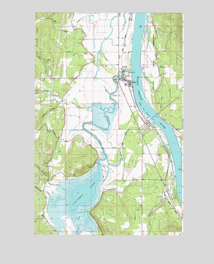
Cusick, WA USGS Topographic Map
Click on map above to begin viewing in our Map Viewer.

This topographic map contains these locations and features:
Feature Name Type Latitude Longitude GNIS ID View Map
Bess Herian Elementary SchoolSchoolN48.3371°W117.2989°1530555View Map
Calispel Valley LibraryBuildingN48.3366°W117.2947°2610155View Map
CalispellPopulated PlaceN48.3438°W117.3005°1517224View Map
Calispell CreekStreamN48.3432°W117.2930°1517226View Map
Calispell LakeReservoirN48.2735°W117.3334°1517227View Map
Calispell Lake DamDamN48.2899°W117.3211°1532365View Map
CusickPopulated PlaceN48.3374°W117.2972°1518433View Map
Cusick Fire DepartmentBuildingN48.3369°W117.2944°2643706View Map
Cusick Junior Senior High SchoolSchoolN48.3370°W117.2988°1530554View Map
Cusick Post OfficePost OfficeN48.3355°W117.2947°2606939View Map
Davis CreekStreamN48.3016°W117.2619°1518504View Map
East Fork Small CreekStreamN48.3274°W117.3544°1519127View Map
Indian Community HallLocaleN48.3449°W117.2694°1521163View Map
Kalispel ReservationCivilN48.3544°W117.2737°1528426View Map
Kalispel Tribal Public Safety DepartmentBuildingN48.3455°W117.2721°2643686View Map
KirchanLocaleN48.3591°W117.2997°1530384View Map
KirchanLocaleN48.3591°W117.2997°1534068View Map
Newport DivisionCivilN48.3163°W117.2812°1939573View Map
Newport Ranger DistrictForestN48.3166°W117.3094°1529628View Map
Onserud Airfield (historical)AirportN48.3132°W117.2908°1530329View Map
Our Lady of SorrowsChurchN48.3424°W117.2708°1531363View Map
Pend Oreille Fire District 4 Station 44BuildingN48.3384°W117.3399°2643684View Map
Skookum CreekStreamN48.2991°W117.2522°1525874View Map
Small CreekStreamN48.3205°W117.3077°1533057View Map
South Fork Small CreekStreamN48.3266°W117.3511°1526253View Map
Town of CusickCivilN48.3328°W117.2961°2412397View Map
UskPopulated PlaceN48.3138°W117.2797°1527654View Map
Usk Post OfficePost OfficeN48.3141°W117.2805°2607036View Map
Winchester CreekStreamN48.2755°W117.3486°1528208View Map

Note: Coordinates in the location and feature list above are referenced to NAD83 datum.


Copyright (C) 2008-2024 Ryan Niemi / Sunset Dynamics ... All Rights Reserved