TopoQuest Logo
Do you find TopoQuest useful?
Help keep TopoQuest running and adding new maps/features by donating!
Bitcoin:  19c7KJd3qBynnjoSw5npx9KScwjBe4ifkT
Litecoin:  LXs6TkuXGGXo1vDsWCkWVdjQX94eUKd6ui
Home View Maps Find Maps Find Places Resources & Links


Jaycox Mountain, Arizona Topographic Map

USGS Map Title: Jaycox Mountain, AZ
USGS Map MRC: 34111G3
DRG (GeoTIFF) Download: o34111g3.tif


Neighboring USGS Topographic Map Quads:


  Mormon Lake, AZ  
34111H4
 

  Kinnikinick Lake, AZ  
34111H3
 

  Chavez Mountain NW, AZ  
34111H2
 

  Hutch Mountain, AZ  
34111G4
 

  Jaycox Mountain, AZ  
34111G3
 

  Chavez Mountain West, AZ  
34111G2
 

  Happy Jack, AZ  
34111F4
 

  Turkey Mountain, AZ  
34111F3
 

  Hay Lake, AZ  
34111F2


Map MRC Location:

N35°
W112°
N35°
W111°
H8 H7 H6 H5 H4 H3 H2 H1
G8 G7 G6 G5 G4 G3 G2 G1
F8 F7 F6 F5 F4 F3 F2 F1
E8 E7 E6 E5 E4 E3 E2 E1
D8 D7 D6 D5 D4 D3 D2 D1
C8 C7 C6 C5 C4 C3 C2 C1
B8 B7 B6 B5 B4 B3 B2 B1
A8 A7 A6 A5 A4 A3 A2 A1
N34°
W112°
N34°
W111°

Jaycox Mountain, AZ USGS 1:24K Topographic Map Preview:
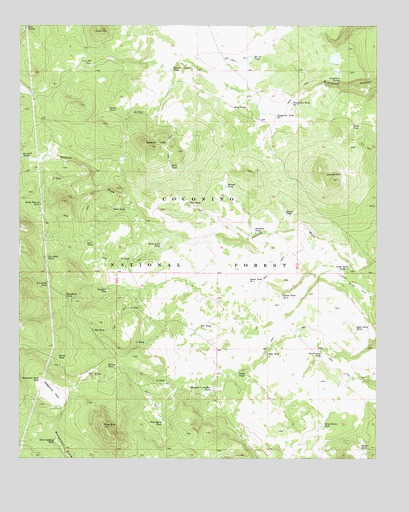
Jaycox Mountain, AZ USGS Topographic Map
Click on map above to begin viewing in our Map Viewer.

This topographic map contains these locations and features:
Feature Name Type Latitude Longitude GNIS ID View Map
Antelope TankReservoirN34.8153°W111.2933°25686View Map
Bargaman ParkFlatN34.7692°W111.3635°25977View Map
Bargaman Park TankReservoirN34.7730°W111.3686°25978View Map
Bell TankReservoirN34.7885°W111.3129°26198View Map
Boondock TankReservoirN34.7963°W111.3581°26602View Map
Buss TankReservoirN34.8511°W111.2993°27069View Map
Butte TankReservoirN34.8342°W111.3229°27092View Map
Cabin TankReservoirN34.7742°W111.2992°27154View Map
Clay TankReservoirN34.8240°W111.3166°27693View Map
Cow HillSummitN34.8739°W111.3476°28088View Map
Cow Hill TankReservoirN34.8637°W111.3508°28089View Map
Doubtful TankReservoirN34.7988°W111.3450°28573View Map
Dove SpringSpringN34.8742°W111.3738°28579View Map
Dutch TankReservoirN34.8508°W111.3449°28701View Map
Elk TankReservoirN34.7870°W111.3497°28864View Map
Fiftyfive TankReservoirN34.7936°W111.3372°28985View Map
Fiftynine TankReservoirN34.8071°W111.3400°28986View Map
Fiftyseven TankReservoirN34.7835°W111.3318°28987View Map
Game and Fish TankReservoirN34.8650°W111.2649°2515338View Map
Gary David TankReservoirN34.7593°W111.2700°29270View Map
Grapevine SpringSpringN34.8584°W111.2641°29528View Map
Grapevine Tank Number OneReservoirN34.8489°W111.2860°29533View Map
Grapevine Tank Number TwoReservoirN34.8520°W111.2809°29534View Map
Hard Luck TankReservoirN34.8113°W111.3260°29743View Map
Hutch TankReservoirN34.7786°W111.3619°30306View Map
Indian Ruin TankReservoirN34.8722°W111.2739°2515337View Map
Jaycox MountainSummitN34.8306°W111.2660°30515View Map
Jaycox TankReservoirN34.8211°W111.2827°30516View Map
JK TankReservoirN34.8496°W111.3359°30456View Map
Johnny TankReservoirN34.8285°W111.3034°30574View Map
Kens TankReservoirN34.8224°W111.3431°30747View Map
Lost TankReservoirN34.8128°W111.3519°31315View Map
Luth Hart TankReservoirN34.8043°W111.2638°31407View Map
Open Draw TankReservoirN34.7869°W111.2574°32539View Map
Pine MountainSummitN34.7592°W111.3457°32955View Map
Pine SpringSpringN34.7744°W111.3521°32975View Map
Pine Spring TankReservoirN34.7748°W111.3513°37990View Map
Pine TankReservoirN34.7802°W111.2892°32981View Map
Powerline TankReservoirN34.8007°W111.3657°33177View Map
Quarter Circle Bar TankReservoirN34.7692°W111.3095°33265View Map
Quarter Corner TankReservoirN34.8624°W111.3229°33271View Map
Rocky Bottom TankReservoirN34.8232°W111.3681°33761View Map
Ruths TankReservoirN34.7525°W111.2548°33892View Map
Sarah Jane TankReservoirN34.7798°W111.2698°34081View Map
Sawmill HillsRidgeN34.8406°W111.3313°34108View Map
Sawmill TanksReservoirN34.8370°W111.3747°34117View Map
Section Twelve TankReservoirN34.8663°W111.2940°34203View Map
Seven Gelding TankReservoirN34.7548°W111.3630°34274View Map
Sin Agua TankReservoirN34.8083°W111.3662°34458View Map
Sixtyone TankReservoirN34.7720°W111.3245°34481View Map
Sixtytwo TankReservoirN34.8307°W111.3646°34483View Map
Snake Number Two DamDamN34.7984°W111.2857°38081View Map
Snake Tank Number OneReservoirN34.8006°W111.2967°34584View Map
Snake Tank Number TwoReservoirN34.7976°W111.2849°34585View Map
Soldier Annex CanalCanalN34.7995°W111.2501°34608View Map
Spring TankReservoirN34.7761°W111.3447°34736View Map
Tower TankReservoirN34.8460°W111.2595°35421View Map
Wild Horse TankReservoirN34.7606°W111.3252°36171View Map

Note: Coordinates in the location and feature list above are referenced to NAD83 datum.


Copyright (C) 2008-2025 Ryan Niemi / Sunset Dynamics ... All Rights Reserved