TopoQuest Logo
Do you find TopoQuest useful?
Help keep TopoQuest running and adding new maps/features by donating!
Bitcoin:  19c7KJd3qBynnjoSw5npx9KScwjBe4ifkT
Litecoin:  LXs6TkuXGGXo1vDsWCkWVdjQX94eUKd6ui
Home View Maps Find Maps Find Places Resources & Links


Jellico West, Tennessee Topographic Map

USGS Map Title: Jellico West, TN
USGS Map MRC: 36084E2
DRG (GeoTIFF) Download: o36084e2.tif


Neighboring USGS Topographic Map Quads:


  Hollyhill, KY  
36084F3
 

  Williamsburg, KY  
36084F2
 

  Saxton, KY  
36084F1
 

  Ketchen, TN  
36084E3
 

  Jellico West, TN  
36084E2
 

  Jellico East, TN  
36084E1
 

  Pioneer, TN  
36084D3
 

  Ivydell, TN  
36084D2
 

  La Follette, TN  
36084D1


Map MRC Location:

N37°
W85°
N37°
W84°
H8 H7 H6 H5 H4 H3 H2 H1
G8 G7 G6 G5 G4 G3 G2 G1
F8 F7 F6 F5 F4 F3 F2 F1
E8 E7 E6 E5 E4 E3 E2 E1
D8 D7 D6 D5 D4 D3 D2 D1
C8 C7 C6 C5 C4 C3 C2 C1
B8 B7 B6 B5 B4 B3 B2 B1
A8 A7 A6 A5 A4 A3 A2 A1
N36°
W85°
N36°
W84°

Jellico West, TN USGS 1:24K Topographic Map Preview:
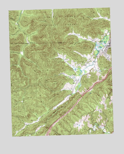
Jellico West, TN USGS Topographic Map
Click on map above to begin viewing in our Map Viewer.

This topographic map contains these locations and features:
Feature Name Type Latitude Longitude GNIS ID View Map
Adams BranchStreamN36.6147°W84.1325°510215View Map
Archer BranchStreamN36.5687°W84.1466°1275843View Map
Baird CreekStreamN36.5709°W84.2394°1276129View Map
Bairds ChapelChurchN36.5092°W84.1447°1318821View Map
Barley BranchStreamN36.5112°W84.2313°1276321View Map
Beard CemeteryCemeteryN36.5156°W84.2238°1276638View Map
Black Oak ChurchChurchN36.5992°W84.1335°516652View Map
Black Oak SchoolSchoolN36.5973°W84.1358°510754View Map
Brickplant HollowValleyN36.5603°W84.1564°1289111View Map
Brickplant Hollow ChurchChurchN36.5595°W84.1560°1318826View Map
Burnt Pone CreekStreamN36.5559°W84.1635°1279104View Map
Calico MountainSummitN36.5542°W84.2049°1311292View Map
Capuchin CreekStreamN36.6051°W84.2347°1305682View Map
City of JellicoCivilN36.5315°W84.1562°2404800View Map
Coal Mine (historical)Populated PlaceN36.5609°W84.1874°1311293View Map
Crooked CreekStreamN36.5634°W84.1599°1281668View Map
Dave Lay HollowValleyN36.5346°W84.2358°1282083View Map
Davis CemeteryCemeteryN36.5340°W84.1355°1282170View Map
Dock HollowValleyN36.5072°W84.1387°1282544View Map
Doolin CemeteryCemeteryN36.5934°W84.1455°511864View Map
Douglas CemeteryCemeteryN36.5620°W84.1363°1282727View Map
Douglas CemeteryCemeteryN36.5679°W84.1669°1953679View Map
Douglas HollowValleyN36.5797°W84.2332°1282738View Map
Elk Fork CreekStreamN36.5387°W84.1799°1303449View Map
Elk Valley Division (historical)CensusN36.5481°W84.1816°1648620View Map
Ellison GapGapN36.5970°W84.1985°516654View Map
Fall BranchStreamN36.5720°W84.1466°1284063View Map
First Baptist ChurchChurchN36.5862°W84.1302°1953698View Map
Good Hope United Baptist ChurchChurchN36.5726°W84.1544°1285625View Map
Hackler CemeteryCemeteryN36.5767°W84.1471°1286477View Map
Hatfield CreekStreamN36.5798°W84.2355°1287129View Map
Hells Point RidgeRidgeN36.5140°W84.2110°1287345View Map
Hoot Owl CemeteryCemeteryN36.5709°W84.1571°1953681View Map
Hoot Owl HollowValleyN36.5675°W84.1435°1311303View Map
Indian CreekStreamN36.5967°W84.1285°512896View Map
Indian MountainSummitN36.5859°W84.1569°1288996View Map
Indian Mountain State ForestForestN36.5865°W84.1410°1318864View Map
Indian Mountain State ParkParkN36.5895°W84.1402°1647489View Map
Jackson CreekStreamN36.6242°W84.1944°510189View Map
Jeff HollowValleyN36.5003°W84.1336°1289322View Map
JellicoPopulated PlaceN36.5879°W84.1269°1289336View Map
Jellico CemeteryCemeteryN36.5812°W84.1360°1289337View Map
Jellico Church of GodChurchN36.5823°W84.1333°1953704View Map
Jellico Community HospitalHospitalN36.5737°W84.1285°1318872View Map
Jellico Elementary SchoolSchoolN36.5754°W84.1291°1318873View Map
Jellico Fire DepartmentBuildingN36.5873°W84.1300°2654436View Map
Jellico Life Saving and Rescue SquadBuildingN36.5879°W84.1293°2654968View Map
Jellico MountainSummitN36.5576°W84.2138°1289339View Map
Jellico Police DepartmentBuildingN36.5874°W84.1298°2765928View Map
Jellico Post OfficePost OfficeN36.5898°W84.1263°1651104View Map
Jellico United Methodist ChurchChurchN36.5879°W84.1258°1953705View Map
Jellico Water Treatment PlantLocaleN36.5826°W84.1385°1953706View Map
Joe HollowValleyN36.5338°W84.2423°1289468View Map
Johnson HollowValleyN36.5314°W84.1358°1289634View Map
Kelsey Switch (historical)LocaleN36.6144°W84.1283°2710188View Map
Kensee ChurchChurchN36.6142°W84.1260°513124View Map
Kensee Coal Mine (historical)MineN36.6147°W84.1457°2710190View Map
Kensee HollowValleyN36.6149°W84.1368°513125View Map
Kensee Railroad Station (historical)LocaleN36.6140°W84.1450°2710078View Map
Lay CemeteryCemeteryN36.5117°W84.2330°1290829View Map
Little Elk CreekStreamN36.5384°W84.1797°1291491View Map
Little Elk SchoolSchoolN36.5126°W84.2238°1291492View Map
Little Elk United Baptist ChurchChurchN36.5106°W84.2316°1318879View Map
Long MountainSummitN36.5526°W84.1588°1291987View Map
Melvin CemeteryCemeteryN36.5106°W84.1694°1293579View Map
Melvin HollowValleyN36.5220°W84.1506°1293580View Map
Negro MountainSummitN36.5523°W84.1944°1295349View Map
NewcombPopulated PlaceN36.5537°W84.1660°1295685View Map
Newcomb Baptist ChurchChurchN36.5548°W84.1694°1318891View Map
Newcomb CemeteryCemeteryN36.5584°W84.1716°1295686View Map
Newcomb Elementary SchoolSchoolN36.5520°W84.1724°1318892View Map
Newcomb Post OfficePost OfficeN36.5526°W84.1685°1651110View Map
North HollowValleyN36.5034°W84.1557°1295925View Map
North Regional EMSBuildingN36.5738°W84.1285°2697434View Map
Old Standard HollowValleyN36.5559°W84.1728°1269842View Map
OswegoPopulated PlaceN36.5701°W84.1563°1311312View Map
Oswego Industrial ParkLocaleN36.5692°W84.1552°1953710View Map
Oswego Missionary Baptist ChurchChurchN36.5684°W84.1574°1296509View Map
Oswego SchoolSchoolN36.5723°W84.1552°1296510View Map
Perkins HollowValleyN36.5991°W84.2271°514493View Map
Perkins-Archer CemeteryCemeteryN36.5640°W84.1463°1953687View Map
Perry BranchStreamN36.6245°W84.1963°514495View Map
Pit GapGapN36.5506°W84.2169°1297733View Map
Proctor HollowValleyN36.5944°W84.1612°514777View Map
Pruitt HollowValleyN36.5045°W84.2434°1298629View Map
Red Ash Coal Camp (historical)Populated PlaceN36.5992°W84.1695°2710205View Map
Rodeheaver ChurchChurchN36.5512°W84.1688°1299956View Map
Sawmill HollowValleyN36.5468°W84.2332°1300841View Map
Smith HollowValleyN36.5181°W84.2158°1270690View Map
Stanville ChurchChurchN36.5092°W84.1491°1271254View Map
Stinking CreekPopulated PlaceN36.5067°W84.1410°1647491View Map
Stinking Creek Elementary SchoolSchoolN36.5073°W84.1419°1648167View Map
Tannery Hollow Missionary Baptist ChurchChurchN36.5776°W84.1280°1953713View Map
Trammel BranchStreamN36.5795°W84.2330°1272837View Map
Trammel RidgeRidgeN36.5665°W84.2263°1272840View Map
Whistle CreekStreamN36.5476°W84.1672°1274311View Map
Whistle Creek MineMineN36.5515°W84.1874°1651124View Map
Whistle Creek RidgeRidgeN36.5376°W84.1969°1274312View Map
WJJT-AM (Jellico)TowerN36.5704°W84.1452°1640006View Map
Wolf KnobSummitN36.6131°W84.2083°516444View Map
WooldridgePopulated PlaceN36.5767°W84.1838°1304677View Map
Woolridge School (historical)SchoolN36.5754°W84.1830°1318945View Map
Zion Hill SchoolSchoolN36.6095°W84.2369°516534View Map

Note: Coordinates in the location and feature list above are referenced to NAD83 datum.


Copyright (C) 2008-2025 Ryan Niemi / Sunset Dynamics ... All Rights Reserved