TopoQuest Logo
Do you find TopoQuest useful?
Help keep TopoQuest running and adding new maps/features by donating!
Bitcoin:  19c7KJd3qBynnjoSw5npx9KScwjBe4ifkT
Litecoin:  LXs6TkuXGGXo1vDsWCkWVdjQX94eUKd6ui
Home View Maps Find Maps Find Places Resources & Links


Jesup NW, Georgia Topographic Map

USGS Map Title: Jesup NW, GA
USGS Map MRC: 31081F8
DRG (GeoTIFF) Download: o31081f8.tif


Neighboring USGS Topographic Map Quads:


  Altamaha SE, GA  
31082G1
 

  Glennville SW, GA  
31081G8
 

  Glennville SE, GA  
31081G7
 

  Odum, GA  
31082F1
 

  Jesup NW, GA  
31081F8
 

  Doctortown, GA  
31081F7
 

  Ritch, GA  
31082E1
 

  Jesup West, GA  
31081E8
 

  Jesup East, GA  
31081E7


Map MRC Location:

N32°
W82°
N32°
W81°
H8 H7 H6 H5 H4 H3 H2 H1
G8 G7 G6 G5 G4 G3 G2 G1
F8 F7 F6 F5 F4 F3 F2 F1
E8 E7 E6 E5 E4 E3 E2 E1
D8 D7 D6 D5 D4 D3 D2 D1
C8 C7 C6 C5 C4 C3 C2 C1
B8 B7 B6 B5 B4 B3 B2 B1
A8 A7 A6 A5 A4 A3 A2 A1
N31°
W82°
N31°
W81°

Jesup NW, GA USGS 1:24K Topographic Map Preview:
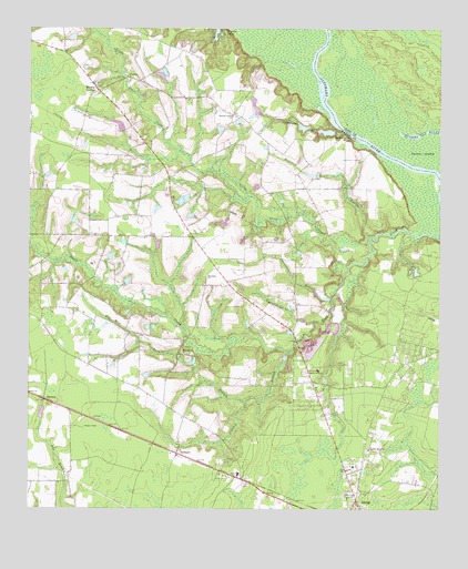
Jesup NW, GA USGS Topographic Map
Click on map above to begin viewing in our Map Viewer.

This topographic map contains these locations and features:
Feature Name Type Latitude Longitude GNIS ID View Map
Altamaha ChurchChurchN31.7377°W81.9704°354292View Map
Bethesda ChurchChurchN31.6858°W81.9465°311217View Map
Bethlehem Wesleyan ChurchChurchN31.7138°W81.9537°350556View Map
Blanton Grove ChurchChurchN31.7277°W81.9387°311522View Map
BurnettPopulated PlaceN31.6535°W81.9948°326202View Map
Carter IslandIslandN31.7169°W81.8804°312382View Map
Cherokee Lakes WestReservoirN31.7493°W81.9433°338530View Map
Consolidated School (historical)SchoolN31.6897°W81.9448°350563View Map
Crossroads Church of GodChurchN31.6569°W81.9123°1686419View Map
Cypresshead BranchStreamN31.6741°W81.9132°313262View Map
DrawdyPopulated PlaceN31.6266°W81.9193°350574View Map
Holstein BranchStreamN31.6960°W81.8968°315586View Map
Little Goose CreekStreamN31.6880°W81.9032°317074View Map
Madray Spring School (historical)SchoolN31.7344°W81.9790°350584View Map
Madray SpringsPopulated PlaceN31.7341°W81.9787°317596View Map
Oglethorpe BluffCliffN31.7230°W81.9043°319921View Map
Oglethorpe BranchStreamN31.7241°W81.9051°319922View Map
Oglethorpe School (historical)SchoolN31.7255°W81.9337°350596View Map
Pinecrest Memorial CemeteryCemeteryN31.6608°W81.9157°320659View Map
Red Hill BranchStreamN31.6630°W81.9515°321375View Map
Red Hill ChurchChurchN31.6658°W81.9526°321382View Map
Red Hill School (historical)SchoolN31.6658°W81.9540°350601View Map
RedlandPopulated PlaceN31.6399°W81.9543°332817View Map
Spring Grove ChurchChurchN31.6408°W81.8965°323401View Map
Spring Grove School (historical)SchoolN31.6449°W81.8962°350606View Map
Stansell BranchStreamN31.6663°W81.9204°323517View Map
Sweetwater BranchStreamN31.6802°W81.9079°323823View Map
Trinity Baptist ChurchChurchN31.6562°W81.8919°2502148View Map
Vickers BranchStreamN31.6530°W81.9337°324689View Map
Wayne County Fire Department Anderson Drive StationBuildingN31.6664°W81.8785°2604786View Map
Wayne County Fire Department Madray Springs StationBuildingN31.7347°W81.9766°2604749View Map

Note: Coordinates in the location and feature list above are referenced to NAD83 datum.


Copyright (C) 2008-2025 Ryan Niemi / Sunset Dynamics ... All Rights Reserved