TopoQuest Logo
Do you find TopoQuest useful?
Help keep TopoQuest running and adding new maps/features by donating!
Bitcoin:  19c7KJd3qBynnjoSw5npx9KScwjBe4ifkT
Litecoin:  LXs6TkuXGGXo1vDsWCkWVdjQX94eUKd6ui
Home View Maps Find Maps Find Places Resources & Links


Jimtown, Montana Topographic Map

USGS Map Title: Jimtown, MT
USGS Map MRC: 45106F6
DRG (GeoTIFF) Download: o45106f6.tif


Neighboring USGS Topographic Map Quads:


  Rough Draw, MT  
45106G7
 

  Colstrip SW, MT  
45106G6
 

  Colstrip SE, MT  
45106G5
 

  Black Spring, MT  
45106F7
 

  Jimtown, MT  
45106F6
 

  Badger Peak, MT  
45106F5
 

  Painted Hill, MT  
45106E7
 

  Lame Deer, MT  
45106E6
 

  Fisher Butte, MT  
45106E5


Map MRC Location:

N46°
W107°
N46°
W106°
H8 H7 H6 H5 H4 H3 H2 H1
G8 G7 G6 G5 G4 G3 G2 G1
F8 F7 F6 F5 F4 F3 F2 F1
E8 E7 E6 E5 E4 E3 E2 E1
D8 D7 D6 D5 D4 D3 D2 D1
C8 C7 C6 C5 C4 C3 C2 C1
B8 B7 B6 B5 B4 B3 B2 B1
A8 A7 A6 A5 A4 A3 A2 A1
N45°
W107°
N45°
W106°

Jimtown, MT USGS 1:24K Topographic Map Preview:
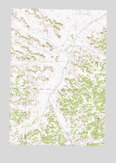
Jimtown, MT USGS Topographic Map
Click on map above to begin viewing in our Map Viewer.

This topographic map contains these locations and features:
Feature Name Type Latitude Longitude GNIS ID View Map
01S40E25ABDB01 WellWellN45.7286°W106.7345°811477View Map
01S41E14CCCB01 WellWellN45.7481°W106.6456°811635View Map
01S41E14D___01 WellWellN45.7481°W106.6289°811634View Map
01S41E15DDCA01 WellWellN45.7469°W106.6489°811627View Map
01S41E23BABC01 WellWellN45.7444°W106.6395°811599View Map
01S41E23BACB01 WellWellN45.7436°W106.6395°811595View Map
01S41E23BDBB01 WellWellN45.7422°W106.6395°811586View Map
01S41E23CAAB01 WellWellN45.7381°W106.6372°811555View Map
01S41E31BABC01 WellWellN45.7147°W106.7214°811355View Map
01S41E32CABA01 WellWellN45.7092°W106.7006°811316View Map
01S41E33DBBC01 WellWellN45.7069°W106.6759°811305View Map
02S41E02BABA01 SpringSpringN45.7014°W106.6392°811253View Map
02S41E08CAD_01 WellWellN45.6775°W106.7006°811054View Map
02S41E08CAD_02 WellWellN45.6767°W106.6981°811042View Map
02S41E08CDAB01 WellWellN45.6755°W106.7000°811036View Map
02S41E08CDAB02 WellWellN45.6755°W106.7000°811037View Map
02S41E08CDAB03 WellWellN45.6761°W106.6989°811039View Map
02S41E09BCA_01 WellWellN45.6836°W106.6839°811097View Map
02S41E17BAA_01 WellWellN45.6722°W106.7011°811008View Map
02S41E17CCD_01 WellWellN45.6600°W106.7050°810897View Map
02S41E17DDD_01 WellWellN45.6597°W106.6895°810894View Map
02S41E19DAA_01 WellWellN45.6511°W106.7109°810808View Map
02S41E19DABA01 WellWellN45.6511°W106.7128°810809View Map
02S41E20BBC_01 WellWellN45.6564°W106.7095°810863View Map
02S41E20CBB_01 WellWellN45.6511°W106.7075°810807View Map
02S41E28BAA_01 WellWellN45.6433°W106.6811°810761View Map
02S41E34BADC01 WellWellN45.6267°W106.6600°810657View Map
02S44E03CADA01 WellWellN45.6914°W106.6595°811175View Map
Bailey RanchLocaleN45.6961°W106.6803°768449View Map
Barb Wood SpringSpringN45.6744°W106.6282°768498View Map
Blackstone CorralLocaleN45.6658°W106.6911°769000View Map
Camp Crook (historical)MilitaryN45.6333°W106.6667°1716710View Map
Camp Merritt (historical)MilitaryN45.6333°W106.6667°1716711View Map
Caswell CouleeValleyN45.6911°W106.6786°769667View Map
Chief Dull Knife CollegeSchoolN45.6256°W106.6646°1716535View Map
Cottonwood CreekStreamN45.6955°W106.6884°770153View Map
Davidson CouleeValleyN45.7064°W106.6731°770467View Map
Davidson School (historical)SchoolN45.7005°W106.6889°1716549View Map
Isaac Kye SpringSpringN45.7016°W106.6389°772739View Map
JimtownPopulated PlaceN45.6789°W106.6881°772828View Map
Lame Deer CemeteryCemeteryN45.6260°W106.6624°1716638View Map
Lame Deer CreekStreamN45.6730°W106.7048°773197View Map
Little Cottonwood CreekStreamN45.7078°W106.6811°773432View Map
Lynch CouleeValleyN45.6542°W106.7167°773769View Map
McKay RanchLocaleN45.7167°W106.6709°774027View Map
North Fork Cottonwood CreekStreamN45.6997°W106.7464°774726View Map
Richard CouleeValleyN45.7439°W106.6478°775745View Map
Rye Grass CreekStreamN45.7233°W106.6689°776043View Map
Saints Rest (historical)Populated PlaceN45.6958°W106.6992°1716742View Map
Slough Grass CreekStreamN45.7189°W106.6798°768084View Map
South Fork Cottonwood CreekStreamN45.6994°W106.7464°776807View Map
Yellow Fox GulchValleyN45.6442°W106.6736°778731View Map

Note: Coordinates in the location and feature list above are referenced to NAD83 datum.


Copyright (C) 2008-2025 Ryan Niemi / Sunset Dynamics ... All Rights Reserved