TopoQuest Logo
Do you find TopoQuest useful?
Help keep TopoQuest running and adding new maps/features by donating!
Bitcoin:  19c7KJd3qBynnjoSw5npx9KScwjBe4ifkT
Litecoin:  LXs6TkuXGGXo1vDsWCkWVdjQX94eUKd6ui
Home View Maps Find Maps Find Places Resources & Links


Jordan, New York Topographic Map

USGS Map Title: Jordan, NY
USGS Map MRC: 43076A4
DRG (GeoTIFF) Download: o43076a4.tif


Neighboring USGS Topographic Map Quads:


  Cato, NY  
43076B5
 

  Lysander, NY  
43076B4
 

  Baldwinsville, NY  
43076B3
 

  Weedsport, NY  
43076A5
 

  Jordan, NY  
43076A4
 

  Camillus, NY  
43076A3
 

  Auburn, NY  
42076H5
 

  Skaneateles, NY  
42076H4
 

  Marcellus, NY  
42076H3


Map MRC Location:

N44°
W77°
N44°
W76°
H8 H7 H6 H5 H4 H3 H2 H1
G8 G7 G6 G5 G4 G3 G2 G1
F8 F7 F6 F5 F4 F3 F2 F1
E8 E7 E6 E5 E4 E3 E2 E1
D8 D7 D6 D5 D4 D3 D2 D1
C8 C7 C6 C5 C4 C3 C2 C1
B8 B7 B6 B5 B4 B3 B2 B1
A8 A7 A6 A5 A4 A3 A2 A1
N43°
W77°
N43°
W76°

Jordan, NY USGS 1:24K Topographic Map Preview:
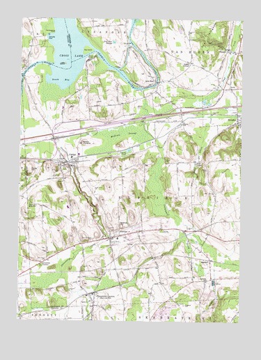
Jordan, NY USGS Topographic Map
Click on map above to begin viewing in our Map Viewer.

This topographic map contains these locations and features:
Feature Name Type Latitude Longitude GNIS ID View Map
Anthonson AirportAirportN43.0792°W76.4089°978096View Map
Ashbys PinnacleSummitN43.0740°W76.4647°942625View Map
BangallPopulated PlaceN43.1123°W76.3830°942959View Map
Big IslandIslandN43.1123°W76.4627°943912View Map
Carpenters BrookStreamN43.0759°W76.4227°945893View Map
Cat HollowValleyN43.0138°W76.3890°946014View Map
Cement PondLakeN43.0709°W76.4388°946171View Map
Champion Mobile Home ParkPopulated PlaceN43.0411°W76.4144°2486390View Map
Cornells CoveBayN43.1173°W76.4835°947469View Map
Crab HollowValleyN43.0626°W76.4021°947621View Map
Cross LakeLakeN43.1241°W76.4794°947804View Map
Crossman CornersLocaleN43.0242°W76.4860°947817View Map
Daboll CornersLocaleN43.1070°W76.4044°947984View Map
ElbridgePopulated PlaceN43.0345°W76.4480°949455View Map
Elbridge Elementary SchoolSchoolN43.0343°W76.4440°2668839View Map
Elbridge Post OfficePost OfficeN43.0337°W76.4484°2617906View Map
Elbridge Rural CemeteryCemeteryN43.0378°W76.4194°949456View Map
Elbridge Rural CemeteryCemeteryN43.0625°W76.4744°2542162View Map
Elbridge Volunteer Fire DepartmentBuildingN43.0377°W76.4312°2701235View Map
Erie CanalCanalN43.1098°W76.4310°973412View Map
Frog Hole SwampSwampN43.1153°W76.4480°950748View Map
HalfwayPopulated PlaceN43.0253°W76.3919°952029View Map
Halfway SchoolSchoolN43.0176°W76.3935°952041View Map
Hart Lot Post OfficePost OfficeN43.0112°W76.4574°1721358View Map
Hillside Mobile Home ParkPopulated PlaceN43.0237°W76.4962°2598485View Map
IoniaPopulated PlaceN43.0967°W76.3813°953749View Map
Ionia CemeteryCemeteryN43.0969°W76.3894°2542164View Map
Jacks ReefPopulated PlaceN43.0992°W76.4241°953875View Map
Jones PointPopulated PlaceN43.1084°W76.4627°954189View Map
JordanPopulated PlaceN43.0653°W76.4730°954196View Map
Jordan - Elbridge High SchoolSchoolN43.0470°W76.4724°2669225View Map
Jordan - Elbridge Middle SchoolSchoolN43.0683°W76.4708°2669168View Map
Jordan Bramley LibraryBuildingN43.0658°W76.4710°2617319View Map
Jordan Fire DepartmentBuildingN43.0661°W76.4774°2701030View Map
Laird CornersLocaleN43.0665°W76.3988°954892View Map
Leubner Apple FarmLocaleN43.0644°W76.4061°2542016View Map
Little IslandIslandN43.1065°W76.4749°955565View Map
Maple Grove CemeteryCemeteryN43.0548°W76.4588°956415View Map
McGraw SwampSwampN43.0776°W76.4413°956773View Map
MemphisPopulated PlaceN43.0828°W76.3772°956958View Map
Memphis Fire DepartmentBuildingN43.0841°W76.3759°2700797View Map
Memphis Post OfficePost OfficeN43.0968°W76.3847°2618021View Map
Millstone Golf CourseLocaleN43.0234°W76.4785°2615440View Map
Mount Pleasant CemeteryCemeteryN43.0342°W76.4583°957886View Map
Pembertons PointCapeN43.1195°W76.4822°960126View Map
PeruPopulated PlaceN43.0823°W76.4080°960222View Map
Plainville FarmsLocaleN43.0764°W76.4789°2515540View Map
Plainville Fire District Company 2BuildingN43.1002°W76.4248°2700852View Map
Preston HillSummitN43.0067°W76.4055°961124View Map
Pump HillSummitN43.0609°W76.4949°961962View Map
Quack HillSummitN43.0615°W76.3785°970506View Map
Quimbys MarinaLocaleN43.1009°W76.4980°973950View Map
Ramsdell Elementary SchoolSchoolN43.0676°W76.4707°2668896View Map
Redman CemeteryCemeteryN43.0626°W76.3938°962331View Map
Rolling Hills Mobile Home CourtPopulated PlaceN43.0392°W76.4228°2486400View Map
Saint Patricks CemeteryCemeteryN43.0623°W76.4777°964064View Map
School Number 11 (historical)SchoolN43.0964°W76.3794°2108573View Map
School Number 12 (historical)SchoolN43.0823°W76.3758°975040View Map
School Number 19 (historical)SchoolN43.1200°W76.4411°2108574View Map
School Number 5 (historical)SchoolN43.0831°W76.4181°2108570View Map
School Number 5 (historical)SchoolN43.1064°W76.4047°2108571View Map
School Number 7 (historical)SchoolN43.0661°W76.3994°2108572View Map
Science HillSummitN43.0395°W76.4422°964645View Map
Shady Brook Mobile Home ParkPopulated PlaceN43.0202°W76.4973°2598489View Map
Skaneateles JunctionPopulated PlaceN43.0112°W76.4574°965342View Map
Skaneateles QuarryMineN43.0031°W76.4142°2567146View Map
South BayBayN43.1020°W76.4766°965666View Map
The KingdomSummitN43.1140°W76.3960°967272View Map
The Kingdom (historical)Populated PlaceN43.1161°W76.4047°2108569View Map
Town of ElbridgeCivilN43.0535°W76.4388°978929View Map
Village of ElbridgeCivilN43.0367°W76.4433°2391660View Map
Village of JordanCivilN43.0671°W76.4729°2390916View Map
Wake Robin FarmLocaleN43.0575°W76.4900°2542074View Map
Walls AirportAirportN43.0434°W76.4606°978001View Map
Weedsport ReservoirReservoirN43.0481°W76.4938°969007View Map
Whiskey HollowValleyN43.1131°W76.3844°971053View Map
White Bottom CreekStreamN43.0926°W76.3944°971074View Map
Whiting Road CemeteryCemeteryN43.0575°W76.4614°2542163View Map
Winter Mobile Home ParkPopulated PlaceN43.0367°W76.4289°2486395View Map

Note: Coordinates in the location and feature list above are referenced to NAD83 datum.


Copyright (C) 2008-2024 Ryan Niemi / Sunset Dynamics ... All Rights Reserved