TopoQuest Logo
Do you find TopoQuest useful?
Help keep TopoQuest running and adding new maps/features by donating!
Bitcoin:  19c7KJd3qBynnjoSw5npx9KScwjBe4ifkT
Litecoin:  LXs6TkuXGGXo1vDsWCkWVdjQX94eUKd6ui
Home View Maps Find Maps Find Places Resources & Links


Jump River Fire Tower NE, Wisconsin Topographic Map

USGS Map Title: Jump River Fire Tower NE, WI
USGS Map MRC: 45090D5
DRG (GeoTIFF) Download: o45090d5.tif


Neighboring USGS Topographic Map Quads:


  Hawkins, WI  
45090E6
 

  Kennan, WI  
45090E5
 

  Pennington, WI  
45090E4
 

  Jump River Fire Tower NW, WI  
45090D6
 

  Jump River Fire Tower NE, WI  
45090D5
 

  Ogema NW, WI  
45090D4
 

  Jump River Fire Tower SW, WI  
45090C6
 

  Jump River Fire Tower, WI  
45090C5
 

  Mondeaux Dam, WI  
45090C4


Map MRC Location:

N46°
W91°
N46°
W90°
H8 H7 H6 H5 H4 H3 H2 H1
G8 G7 G6 G5 G4 G3 G2 G1
F8 F7 F6 F5 F4 F3 F2 F1
E8 E7 E6 E5 E4 E3 E2 E1
D8 D7 D6 D5 D4 D3 D2 D1
C8 C7 C6 C5 C4 C3 C2 C1
B8 B7 B6 B5 B4 B3 B2 B1
A8 A7 A6 A5 A4 A3 A2 A1
N45°
W91°
N45°
W90°

Jump River Fire Tower NE, WI USGS 1:24K Topographic Map Preview:
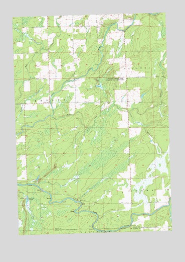
Jump River Fire Tower NE, WI USGS Topographic Map
Click on map above to begin viewing in our Map Viewer.

This topographic map contains these locations and features:
Feature Name Type Latitude Longitude GNIS ID View Map
1 ReservoirReservoirN45.4750°W90.5751°1793274View Map
Fairview School (historical)SchoolN45.4425°W90.5335°1840343View Map
Hobbles CreekStreamN45.4427°W90.5954°1579461View Map
Lonely Pines AirportAirportN45.4762°W90.6238°1582033View Map
Lower Steve Creek 2WP1332 DamDamN45.3983°W90.6201°1792797View Map
Marsh CreekStreamN45.4039°W90.6118°1579815View Map
Meadow Creek School (historical)SchoolN45.4575°W90.5968°1840344View Map
Red Tile School (historical)SchoolN45.4841°W90.5340°1840345View Map
Ronald Winter H1876 DamDamN45.4750°W90.5751°1793273View Map
Steve Creek FlowageReservoirN45.3950°W90.6174°1580531View Map
Town Corners Wildlife Flowage E12.67 DamDamN45.4583°W90.5585°1792909View Map
Town of KennanCivilN45.4631°W90.6181°1583471View Map
Township Corners FlowageReservoirN45.4589°W90.5560°1792910View Map
Township Corners State Wildlife Management AreaParkN45.4608°W90.5532°1580639View Map
Yellow BanksCliffN45.3919°W90.5732°1580837View Map

Note: Coordinates in the location and feature list above are referenced to NAD83 datum.


Copyright (C) 2008-2025 Ryan Niemi / Sunset Dynamics ... All Rights Reserved